
Twelvemile Creek Wilderness Study Area
The Trout Creek Mountains Group of Wilderness Study Areas includes five areas:
- Willow Creek (OR-3-152) which has 30,565 acres (28,810 acres of BLM land and 1,755 acres of split-estate);
- Disaster Peak (OR-3-153/NV-020-859) which has 18,840 acres (17,290 acres of BLM land and 1,550 acres of split-estate) (an additional 13,200 acres of BLM land located in Nevada are included in the Nevada Wilderness Study);
- Fifteenmile Creek (OR-3-156) which has 51,290 acres (48,540 acres of BLM land and 2,750 acres of split-estate);
- Oregon Canyon (OR-3-157) which has 42,900 acres (40,400 acres of BLM land and 2,500 acres of split-estate); and
- Twelvemile Creek (OR-3-162) which has 28,600 acres (26,960 acres of BLM land and 1,640 acres of split-estate).
In addition there are 1,520 acres of private inholdings in the WSA Group (920 acres in Willow Creek, 40 acres in Disaster Peak, 200 acres in Fifteenmile Creek and 360 acres in Twelvemile Creek).
These contiguous WSAs are located in Malheur and Harney Counties, Oregon, and Humboldt County in northern Nevada, between 8 to 28 miles northwest of McDermitt, Nevada and U.S. Highway 95. The portion of the Disaster Peak WSA located in Nevada was included in the Nevada Wilderness Study Report. The Oregon portion is analyzed in this report.
The five together contain 162,000 acres of BLM land and 10,195 acres of split-estate land. The split-estate lands consist of 24 parcels that are evenly dispersed in a checkerboard pattern across the group of WSAs. Also within the WSAs or between the boundaries of adjacent WSA are 2,680 acres of private land in 28 parcels of various sizes. All but five are 40-acre parcels. The five irregular parcels are 1,240 acres, 1,120 acres, 280 acres, 160 acres and 80 acres. The majority of the private property is concentrated in the west side of the group of WSAs (including the two largest parcels) and the remainder are mainly in the upper northeast portion of the group.
Each WSA has distinctive natural characteristics, the most unique being the following:
The Willow Creek WSA has diverse terrain varying from gentle relief in the north and south to deep, wide canyons of sheer basalt rims and talus slopes in the central region.
The Disaster Peak WSA sits along the northwest rim of the McDermitt Caldera, forming part of the divide that separates the Coyote Lake Basin from the Humboldt Basin. The landmark known as Disaster Peak is a large, symmetrical butte that is visible throughout the region. The western-most portion of the WSA incorporates part of an area known as The Granites, named after the abundance of very old granitic outcrops that appear at the base of the predominantly volcanic ridgeline.
Topography of the Fifteenmile WSA consists of long, deep, steep-walled canyons separated by broad smoothly rounded ridges. The canyon slopes are broken by outcrops and slopes, while the ridge tops are flat or gently rolling.
The Oregon Canyon WSA consists of a few long ridgelines, a deep canyon and its two steep-walled forks, and many relatively short and precipitous canyons which drain the eastern and southern slopes. The ridge tops are broken by rock outcrops, rims, and scree slopes.
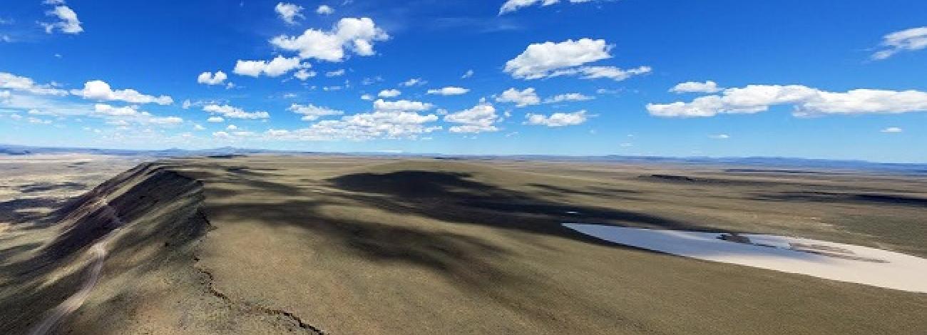
The Twelvemile WSA consists of two fault block plateaus, steeply scarped on the east and sloping gently toward the northwest. Four major canyons originate near the southeastern edge of the study area and cut deeply as they radiate to the north and northwest in a array. They are steep-sided, edged with rimrock, and intersected by many tributary drainages. The ridge tops are broad and flat to gently rolling.
The WSAs were studied under Section 603, with additional acquired split estate lands studied under Section 202 of the Federal Land Policy and Management Act (FLPMA), and the group was included in the Final Oregon Wilderness Environmental Impact Statement (EIS) filed in February 1990.


