
Table Rock Wilderness
The United States Congress designated the Table Rock Wilderness in 1984 and it now has over 5,786 acres. All of this wilderness is located in Oregon and is managed by the Bureau of Land Management.
A remnant of a lava flow that once covered this region along the western foothills of the Cascades, the "fortress" of Table Rock stands at 4,881 feet above the northeastern portion of this small Wilderness. On this steep and rugged terrain you'll find a quiet forest of Douglas fir and western hemlock, with noble fir at higher elevations and crowds of rhododendron on many of the upper slopes, an island of old growth in an ocean of forest development. At least two endangered plants bloom here: Oregon sullivantia and Gorman's aster. Deer and elk wander about in winter, and the northern spotted owl has been spotted among the old trees.
- Directions
To reach Table Rock Wilderness, located 19 miles southeast of Molalla, Oregon take the Woodburn exit from Interstate 5. Travel east on Highway 211 to Molalla. From the east end of Molalla follow signs to Feyrer Park. From Feyrer Park turn right on South Dickie Prairie Road. Travel on South Dickie Prairie Road to the bridge at Glen Avon. Cross the bridge, turn left and travel south 12 miles on South Molalla Road to the junction of Middle Fork and Copper Creek roads. A right turn leads to the Old Bridge Trailhead, immediately across the bridge. A left turn leads to the Table Rock Trailhead.
- Know Before You Go
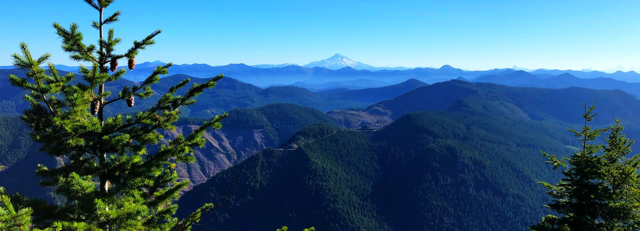
From four trailheads, about 17 miles of trails give access to the Wilderness. A moderately difficult hike from Table Rock Road will take you up the Table Rock Trail to the sweeping vista from the summit of Table Rock, where the land falls suddenly away in basalt cliffs on the north face. From this high point, Mount Rainier looms far to the north, Bull of the Woods Wilderness beckons from the east, and the Willamette Valley spreads out to the south.
You will not find any reliable sources of potable water on the trails, so pack along your own. Horses may find dangerous footing on some of the talus slopes.
Visitors can help in protecting this fragile ecosystem by adequately planning and by arriving prepared! Knowledge of the area, weather, terrain, and common sense can help to ensure you have a safe, fun, and memorable trip to the wild. Trail junctions are generally unsigned, so you should carry a map and a compass. And always be sure to bring your ten essentials!
- Management Background
The Table Rock Wilderness is part of the 110 million acre National Wilderness Preservation System. This System of lands provides clean air, water, and habitat critical for rare and endangered plants and animals. In wilderness, you can enjoy challenging recreational activities like hiking, backpacking, climbing, kayaking, canoeing, rafting, horse packing, bird watching, stargazing, and extraordinary opportunities for solitude. You play an important role in helping to "secure for the American people of present and future generations the benefits of an enduring resource of wilderness" as called for by the Congress of the United States through the Wilderness Act of 1964. Please follow the requirements outlined below and use Leave No Trace techniques when visiting the Table Rock Wilderness to ensure protection of this unique area.
Unless otherwise specified, no motorized equipment or mechanical transport, with the exception of wheelchairs, is allowed. This is generally true for all federal lands managed as designated wilderness.
- Planning
Since 2008, the Northwest Oregon District (formerly the Salem District) has been working with a variety of stakeholders to develop an appropriate management strategy for the Molalla River-Table Rock recreation area. Located southeast of the city of Molalla, Oregon in the Cascade Mountains, the recreation area is a popular destination for swimming, camping, fishing, hiking, horseback riding, boating and biking. It includes approximately 27,000 acres of public land and hosts between 60,000 and 70,000 visitors annually.
The Bureau of Land Management has made a final decision and issued a final Recreation Area Management Plan for the Molalla River-Table Rock recreation area. The Plan articulates a strategy for the management of recreation resources within the planning area for the next 15 years.
The final Management Plan includes detailed direction for the management of overnight use, day use, trails, visitor information and administration. It also lays out specific development projects and management actions that may be taken during the 15 year lifespan of the plan.
- Table Rock Hiking
The Table Rock Trailhead offers the shortest and most accessible route to Table Rock via the Table Rock Trail and Summit Trail. The hike is a moderately difficult 3.3 miles, and climbs approximately 1000 feet. The Summit trail crosses a moderately challenging boulder field near the base of the north face. At an elevation of 4,881 feet, Table Rock is the highest point in the Wilderness, and offers an exceptional view of the Cascade Range. On a clear haze-free day, visitors to the summit may be able to see — north to south — Mt. Rainier, Mt. St. Helens, and Mt. Adams in Washington; Mt. Hood, Mt. Jefferson, Three-fingered Jack, Mt. Washington, North, Middle, and South Sisters in Oregon; and Mt. Shasta in California.
The Rooster Rock Trailhead is located at the end of Rooster Rock Road. Rooster Rock Trail, a short, but very steep trail, connects with the High Ridge Trail and provides great access to Rooster Rock and Pechuck Lookout. Rooster Rock boasts incredible views of Table Rock and Mount Jefferson on a clear day. Pechuck Lookout is a historic two-story cupola fire lookout and is listed on the National Historic Lookout Register. Volunteers help the BLM maintain the structure so visitors can enjoy the site. No reservations are required. Please leave the Lookout as you found it.
The Old Bridge Trailhead provides access to the High Ridge Trail, a trail which presents the most serious challenge to hikers in the Table Rock Wilderness. The trail climbs over 3,200 feet from the trailhead to Rooster Rock. The first 2 miles are steep, moderately burned and involve multiple switchbacks. East of the Bull Creek Trail junction, the High Ridge Trail traverses a burned area, with multiple downed logs. Trail navigation is difficult in this area, and travel here is not recommended. In areas that have not been burned, the trail is sheltered by a forest canopy of Douglas fir and western hemlock. During June and July visitors are treated to a dazzling display of flowering rhododendron.
Bull Creek Trailhead is obscure and the trail travels through an intensely burned area. The trail is open and generally free of obstructions, but travel to the east, on the High Ridge Trail, is not recommended due to multiple downed trees that have not yet been cleared. Similarly, the Image Creek Trail is obscure and severely overgrown.