
Carrizo Plain National Monument
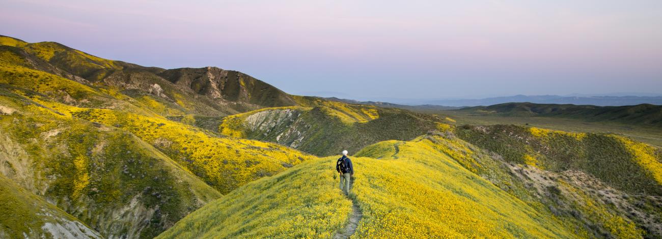
Three hundred years ago, California’s Central Valley was vast grassland where pronghorn and elk grazed and wildflowers swept the spring landscape. Today, amid urban and agriculture development, a remnant remains in the Carrizo Plain National Monument.
Carrizo Plain National Monument is one of the best kept secrets in California. Only a few hours from Los Angeles, the Carrizo Plain offers visitors a rare chance to be alone with nature. Some visitors say you can "hear the silence." The plain is home to diverse communities of wildlife and plant species including several listed as threatened or endangered and is an area culturally important to Native Americans.
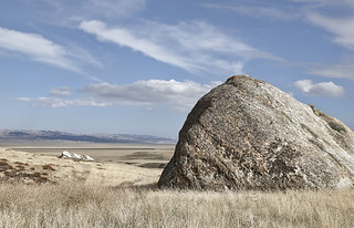
This remote monument, traversed by the San Andreas Fault which has carved valleys, created and moved mountains, and yet up close, is seen in subtle alignment of ridges, ravines and normally dry ponds. Prominent features on the monument include the white alkali flats of Soda Lake, Painted Rock, vast open grasslands, and a broad plain rimmed by mountains. When conditions are right, numerous wildflowers can carpet the valley floor; although short lived it can be breathtaking.
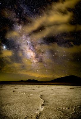
Soda Lake, normally a dry lake bed, is one of the dominant geographic features of the Carrizo Plain. It is the largest remaining natural alkali wetland in southern California and the only closed basin within the coastal mountains. As its name suggests, Soda Lake concentrates salts as water evaporates, leaving white deposits of sulfates and carbonates that look like baking soda.
Planning Your Visit
Prepare yourself for your adventure. The Carrizo Plain National Monument does not provide any services such as water, food, or fuel. Plan your trip accordingly and ensure you get these items in one of the neighboring communities before you come (see Gateway Communities). These communities lie 15 miles from the south entrance and 60 miles from the north entrance. Also, ensure you bring the appropriate apparel for the time of year you are visiting.
Special Rules for the Carrizo Plain National Monument
Please observe the following rules during your visit to the Carrizo Plain National Monument.
Painted Rock Exclusion Zone: The following items/activities are not allowed in the Painted Rock Exclusion Zone: Horses and dogs, non-motorized bicycles (except the Painted Rock parking area), cache-type activities (geocaching, earth caching, etc.), discharge of firearms, and campfires.
Pictographs and Petroglyphs: The making of digital, photographic, print, or video images of any of the pictographs or petroglyphs, or any graffiti that overlies or is adjacent to, for commercial use is not allowed.
Weapons: Recreational target shooting is prohibited within the entire monument. Public lands within 1/4 mile of any campground, Painted Rock, facility (including the Washburn, Saucito, and MU ranch headquarters), developed overlooks, interpretive sites or pullouts, are closed to the discharge of firearms. Use of replica weapons (such as paintball, airsoft, or war game apparatus is not allowed on the monument. In addition, there is a No Shooting Zone established/marked around Painted Rock and the Goodwin Education Center.
Access: All public lands within 1/4 mile of Sulphur Springs are closed to public access, in order to protect sensitive resources. All public lands within 1/4 mile of Painted Rock are closed to public access from March 1 through July 15 each year, except for tours authorized by the Bureau of Land Management, for the same reason.
Visitors Center
Goodwin Education Center
Phone: 661-391-6191
Open: December 1 - May 31.
Hours: 9:00 a.m. - 4:00 p.m., Thursday - Sunday
Maps and brochures are available at the front door when the center is closed. Wheelchair accessible restrooms at the Education Center remain open 24 hours a day, seven days a week, throughout the year.
Contact the Education Center or make it your first stop to receive updated information about your visit to the Carrizo Plain National Monument.
Get permits for Guided and Self-Guided Tours
Download the Carrizo Plain National Monument Recreation Map and Guide
- Accessibility
Click on the following links to read more about accessibility features at the Carrizo Plain National Monument.
Goodwin Education Center- View photos of Accessibility features: https://www.flickr.com/photos/blm_wo_recreation/albums/72177720333281604/
- View photos of Accessibility features: https://www.flickr.com/photos/blm_wo_recreation/albums/72177720333252100/
- View photos of Accessibility features: https://www.flickr.com/photos/blm_wo_recreation/albums/72177720333853005/
- View photos of Accessibility features: https://www.flickr.com/photos/blm_wo_recreation/albums/72177720333273143/
- View photos of Accessibility features: https://www.flickr.com/photos/blm_wo_recreation/albums/72177720333852297/
- View photos of Accessibility features: https://www.flickr.com/photos/blm_wo_recreation/albums/72177720333853585/
- Weather
Expect warm, dry summers and cool, wet winters. Most rain falls between November and April with occasional snow. Average summer temperatures range from the low 50s°F at night to the upper 90s°F during the day. Daytime temperatures often exceed 100°F, with a record high of 115°F. Average winter temperatures range from highs in the mid 60s to lows in the mid 30s, with a record low of 0°F. The Carrizo Plain receives between 7–10 inches of annual rainfall on the valley floor.
- Pets
Pets must be controlled at all times. In addition, pets must be leashed or caged at all developed sites including the visitor center, interpretive overlooks, trail heads, and camping areas. No pets are allowed in the Painted Rock exclusion zone.
- Nearest Highway Access
The Carrizo Plain has two major sources of access. From the north, the access is via Soda Lake Road off of State Route 58. The other major access is from the south via Soda Lake Road off of State Route 33/166.
- Gateway Communities
Gateway Communities located near the Monument help inform and educate the public about the opportunities on the Carrizo Plain National Monument. They also provide services (food, fuel, water) not available on the Monument. Taft is located east of Carrizo Plain and offers Monument information at the Chamber of Commerce and Visitor Center at 400 Kern Street. You can visit their website: http://www.taftchamber.com. Taft offers a variety of businesses, including grocery stores, fuel, and lodging. Santa Margarita is located northwest of the Monument and offers visitors information on Main Street (El Camino Real), look for visitor information signs. Santa Margarita offers fuel, food, and shops.
Quick Facts
Proclamation
Created: January 17, 2001
Size: 211,045 acres of public land
Quick Links
Plan Your Visit
- Wildflower Updates
- Visit Carrizo Plain
- Goodwin Education Center
- Guided and Self-Guided Tours
Partners
Managers Reports
Flickr Album
Chronolog Link
Contact Us
Carrizo Plain National Monument
Visitor Center
17495 Soda Lake Road
California Valley, CA 93453
Phone: 661-391-6191
Information Line: 661-391-6193
Email: [email protected]
Bureau of Land Management
Bakersfield Field Office
35126 McMurtrey Ave
Bakersfield, CA 93308
Phone: 661-391-6000
Email: [email protected]