
Campbell Tract WWII History
Most visitors to the Campbell Tract come to enjoy a walk or bike ride on the 12 miles of unpaved trails. However, many visitors don't know the Campbell Tract played a military role in World War II. Remnants of bomber parking pads and taxiways, building foundations, foxholes, and defensive earthworks can still be seen today.
Wartime preparation and construction
In 1942, more than 7,000 acres of federal public lands to the south and east of Anchorage were withdrawn for military use by the War Department.
The U.S. Army constructed a primitive jeep trail from the small railroad town of Anchorage through the untouched birch forest to the current site of Campbell Tract. This trail was improved to become a wider gravel road which crossed the South Fork of Campbell Creek by means of a ford. After the war, the military road became known as Campbell Airstrip Road.
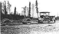
Army Engineers then constructed Campbell Airfield, a 5,000-foot gravel runway south of the creek. The airstrip was built to help disperse aircraft and crews away from Ft. Richardson in the event of a Japanese attack. Similar satellite airstrips were built at Birchwood, Willow, and Goose Bay. Aircraft scattered at different fields would lessen the chance of all planes being destroyed in one attack.
Campbell Airfield and Garrison
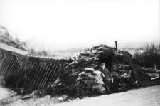
Campbell Airfield consisted of wide gravel taxiways and tactically dispersed aircraft parking spots. The airfield was supported by an Army Air Corps garrison. Initially soldiers built a guard shack and barracks huts out of saplings and insulated them with double layers of sod (photo at right). With its tents and improvised shelters, Campbell Garrison looked more like a Boy Scout camp than a military installation. A Quonset hut camp was later constructed near Campbell Creek.
Temporary structures and Quonset huts
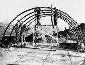
After the war, Quonset huts at Campbell Creek were removed, but many features of this period remain. The airstrip, taxiways, aircraft parking areas, foxholes, and concrete foundations can still be seen at Campbell Tract today. And several old military surplus Quonset huts are still in use today in other parts of Anchorage.
- Foxholes for Fighting Planes panel
-
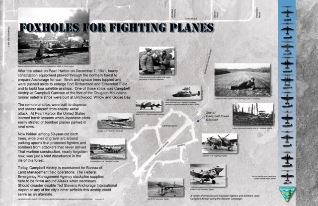
(The following text appears on the above panel)After the attack on Pearl Harbor on December 7, 1941, heavy construction equipment plowed through the northern forest to prepare Anchorage for war. Birch and spruce trees toppled and were pushed aside to enlarge Fort Richardson and Elmendorf Field and to build four satellite airstrips. One of those strips was Campbell Airstrip at Campbell Garrison at the foot of the Chugach Mountains. Similar satellite strips were built at Birchwood, Willow and Goose Bay.
The remote airstrips were built to disperse and shelter aircraft from enemy aerial attack. At Pearl Harbor the United States learned harsh lessons when Japanese pilots easily strafed or bombed planes parked in neat rows.
Now hidden among 50-year-old birch trees, wide piles of gravel arc around parking aprons that protected fighters and bombers from attackers that never arrived. That wartime construction, nearly forgotten now, was just a brief disturbance in the life of this forest.
Today, Campbell Airstrip is maintained for Bureau of Land Management field operations. The Federal Emergency Management Agency stockpiles supplies here to be flown around Alaska when necessary. Should disaster disable Ted Stevens Anchorage International Airport or any of the city’s other airfields, this airstrip could serve as an alternate.
Photo captions and credits:
- Pilots survived brutal weather and hostile geography to fight the Japanese. (3rd Wing History Office, Elmendorf AFB) (Now known as 673d ABW, Joint Base Elmendorf-Richardson.)
- Campbell Creek Garrison cook reclining on part of a taxiway (F. Robert Grant)
- Heavy equipment clearing land for Campbell Airstrip (Army Corps of Engineers)
- North American B-25 "Mitchell" bombers attacked Japanese positions on Attu & Kiska. (Army Air Corps)
- Boeing B-17 "Flying Fortress" bomber (Army Air Corps)
- Douglas C-47 "Skytrain" transport (Army Air Corps)
- Consolidated B-24 "Liberator" bomber (Army Air Corps)
- Lockheed P-38 "Lighting" fighter (Army Air Corps)
- Curtiss P-40 "Warhawk" fighter (Army Air Corps)
- Bell P-39 "Airacobra" fighter (Army Air Corps)
- Aircraft identification silhouettes used to identify Allied planes
- A variety of American and Canadian fighters and bombers used Campbell Airstrip during the Aleutian Campaign.
- Background aerial photo: Campbell Airstrip, August 1950, showing adjacent parking aprons, taxiways, and surrounding forest (Aeromap U.S.)
- Sailors at NAS Ford Island watch the Japanese air attack on Pearl Harbor. (National Archives)
- Japanese Troops Invade Alaska panel
-
(The following text appears on the above interpretive panel)
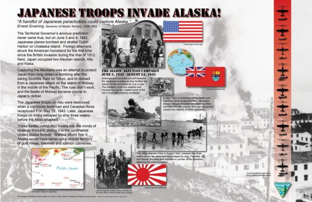
“A handful of Japanese parachutists could capture Alaska.” —Ernest Gruening, Governor of Alaska Territory, 1939-1953
The Territorial Governor’s anxious prediction never came true, but on June 3 and 4, 1942, Japanese planes bombed and strafed Dutch Harbor on Unalaska Island. Foreign attackers struck the American homeland for the first time since the British invasion during the War of 1812. Next, Japan occupied two Aleutian Islands, Attu and Kiska.
Capturing the Aleutians was an attempt to protect Japan from long-distance bombing after the daring Doolittle Raid on Tokyo, and to distract from a Japanese attack on the Island of Midway in the middle of the Pacific. The ruse didn’t work, and the Battle of Midway became crucial to Japan’s defeat.
The Japanese troops on Attu were destroyed when a combined American and Canadian force recaptured it on May 29, 1943. Later, Japanese troops on Kiska escaped by ship three weeks before the Allies attacked.
These battles catapulted Alaska into the minds of strategic thinkers, linking it to the continental United States forever. Without World War II, Alaska would have remained a remote territory of gold mines, sawmills and salmon canneries.
Photo captions and credits:
The Allies’ Aleutian Campaign June 3, 1942 - August 24, 1943 - American and Canadian aircraft harassed the Japanese invaders as they fortified the islands of Attu and Kiska for over a year. The Aleutians’ notorious weather and mountainous terrain created some of the war’s most difficult flying conditions. (Alaska State Library, U.S. Army Signal Corps) In May 1943, a combined United States and Canadian force recaptured Attu. Japanese banzai charges shredded the attacking Allies, but bitter Aleutian weather and poor equipment caused the majority of Allied casualties. (Anchorage Museum of History and Art) The Allies attacked Kiska in August 1943, unaware that three weeks earlier the Japanese had escaped by sea. Tragically, fog and friendly fire killed and wounded a number of the liberators attacking the deserted island. (Anchorage Museum of History and Art) Only 28 Japanese soldiers lived to surrender on Attu, after officers ordered deadly banzai charges. (Anchorage Museum of History and Art) Aircraft identification silhouettes used to identify Japanese planes The Japanese bombing of Dutch Harbor on June 3-4, 1942, killed 25 civilians and started numerous fires. (Anchorage Museum of History and Art)
- Campbell Garrison: War in the Woods panel
-
(The following text appears on the above interpretive panel.)
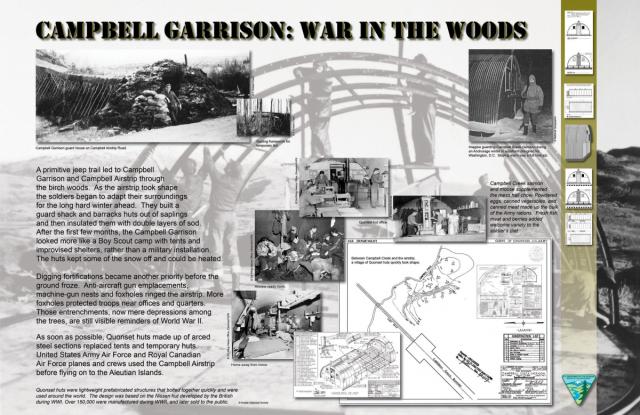
A primitive jeep trail led to Campbell Garrison and Campbell Airstrip through the birch woods. As the airstrip took shape, the soldiers began to adapt their surroundings for the long hard winter ahead. They built a guard shack and barracks huts out of saplings and then insulated them with double layers of sod. After the first few months, the Campbell Garrison looked more like a Boy Scout camp with tents and improvised shelters, rather than a military installation. The huts kept some of the snow off and could be heated.
Digging fortifications became another priority before the ground froze. Anti-aircraft gun emplacements, machine-gun nests, and foxholes ringed the airstrip. More foxholes protected troops near offices and quarters. Those entrenchments, now mere depressions among the trees, are still visible reminders of World War II.
As soon as possible, Quonset huts made up of arced steel sections replaced tents and temporary huts. Army Air Corps and Royal Canadian Air Force planes and crews used the Campbell Airstrip before flying on to the Aleutian Islands.
Photo captions and credits:
- Campbell Garrison guard house on Campbell Airstrip Road (F. Robert Grant)
- Sapling framework for temporary hut (F. Robert Grant)
- Imagine guarding Campbell Creek Garrison during an Anchorage winter in a uniform designed for Washington, D.C. Staying warm was a full-time job. (National Geographic)
- Campbell Creek salmon and moose supplemented the mess hall chow. Powdered eggs, canned vegetables, and canned meat made up the bulk of Army rations. Fresh fish, meat and berries added welcome variety to the soldier's diet. (National Archives)
- Quonset hut office (3rd Wing History Office, Elmendorf AFB) (Now known as 673d ABW, Joint Base Elmendorf-Richardson.)
- Air crew ready room (3rd Wing History Office, Elmendorf AFB) (Now known as 673d ABW, Joint Base Elmendorf-Richardson.)
- Home away from home (3rd Wing History Office, Elmendorf AFB) (Now known as 673d ABW, Joint Base Elmendorf-Richardson.)
- Quonset hut mess hall kitchen (National Archives)
- Between Campbell Creek and the airstrip, a village of Quonset huts quickly took shape.
- Quonset huts were lightweight, prefabricated structures that bolted together quickly and were used around the world. The design was based on the Nissen hut developed by the British during W. W. I. Over 150,000 were manufactured during W.W. II, and later were sold to the public for $1,000. (Kodiak Historical Society)
- A Frontier Town Grows Up panel
-
(The following text appears on the above interpretive panel.)
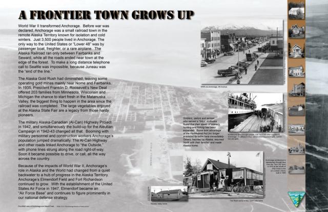
World War II transformed Anchorage. Before war was declared, Anchorage was a small railroad town in the remote Alaska Territory known for isolation and cold winters. Just 3,500 people lived in Anchorage. The only way to the United States or "Lower 48" was by passenger boat, freighter, or a rare airplane. The Alaska Railroad ran only between Fairbanks and Seward, while all the roads ended near town at the edge of the forest. To make a long-distance telephone call to Seattle was impossible, because Juneau was the "end of the line."
The Alaska Gold Rush had diminished, leaving some operating gold mines mainly near Nome and Fairbanks. In 1935, President Franklin D. Roosevelt’s New Deal offered 203 families from Minnesota, Wisconsin and Michigan the chance to start fresh in the Matanuska Valley, the biggest thing to happen in the area since the railroad was completed. The large vegetables enjoyed at the Alaska State Fair are a legacy from those hardy pioneers.
The military Alaska-Canadian (Al-Can) Highway Project in 1942, and simultaneously the build-up for the Aleutian Campaign in 1942-43, changed all that. Booming with military personnel and construction workers, Anchorage's population jumped dramatically. The Al-Can Highway and other roads linked Anchorage to “the Outside,” with phone lines strung along the road right-of-way. Soon it became possible to drive, or call, all the way across the country.
Because of the impacts of World War II, Anchorage's role in Alaska and the world had changed from a quiet backwater to a hub of progress in the Alaska Territory. Anchorage’s Elmendorf Field and Fort Richardson continued to grow. With the establishment of the United States Air Force in 1947, Elmendorf became an “Air Force Base” and continues to figure prominently in our national defense strategy. (And as part of what is now known as Joint Base Elmendorf-Richardson.)
Photo captions and credits:
- WWII- era Anchorage, 4th Avenue (Anchorage Museum of History and Art)
- Northbound ships brought people, mail, food and other supplies to Anchorage. Southbound ships carried returning passengers, salmon, furs, and gold. (Anchorage Museum of History and Art)
- Soldiers, sailors and airmen who served a "hitch" in Alaska found that their ideas of scenery, hunting, and fishing had been expanded. Some took advantage of the Homestead Act (no longer available) to settle here immediately. Others, haunted by Alaska, returned North with their families and made Alaska home.
- Anchorage architecture is represented through time from the "Tent City" born in 1915 at the mouth of Ship Creek to the ZJ Loussac Library, built in 1986.
- The Risch family in their Sand Lake home (Anchorage Museum of History and Art)
- Nunaka Valley home (Anchorage Museum of History and Art
- Pre W.W. II view of Anchorage and Merrill Field (Anchorage Museum of History and Art)
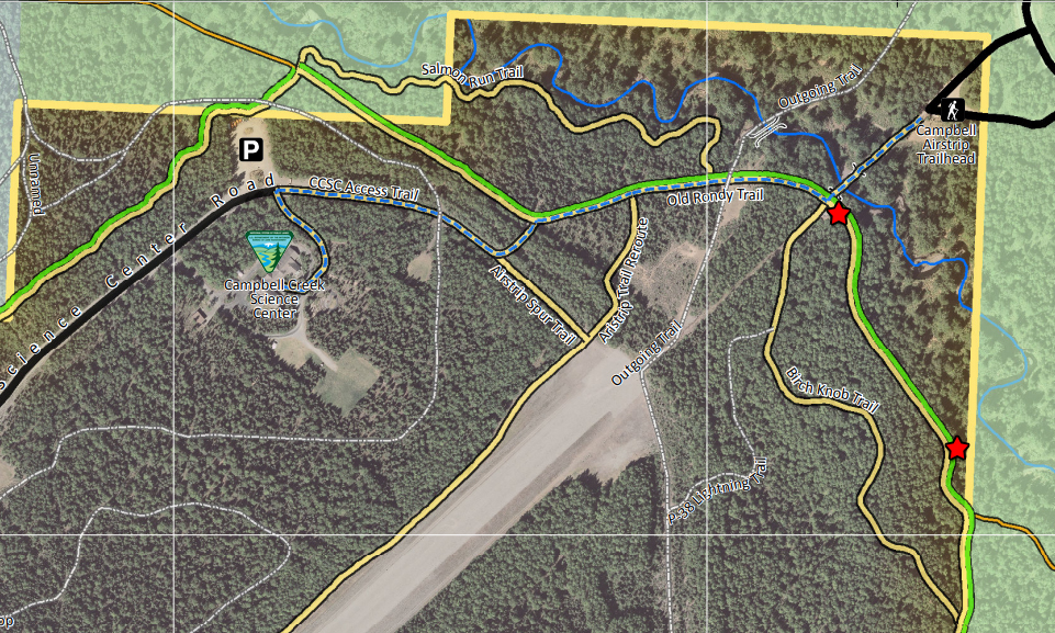
Visit Campbell Tract
For those of you interested in the history of the Campbell Tract, the BLM has installed four interpretive panels at various trailheads on the tract.
You can also view them here:
Point of Contact
Jenny Blanchard
Archaeologist
(907) 267-1341
[email protected]
Junior Ranger missions for the Agents of Discovery app
Explore Campbell Tract all year long with Junio Ranger missions ranging from Snow and Ice exploration to Dinosaurs!