
Prescribed fire planned for public lands on the Arizona Strip
Organization:
Media Contact:
ST. GEORGE, Utah—To decrease the risk of future wildfires and protect cultural and natural resources, the Bureau of Land Management’s (BLM) Arizona Strip District anticipates initiating prescribed fire treatments this fall from August through November, as weather and fuel moisture conditions allow.
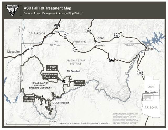
The Saddle prescribed fire treatment will take place 65 miles south of St. George, Utah near Mt. Trumbull along County Road 5, BLM Road 1783, and BLM Road 1781. This prescribed fire treatment will focus on reducing the surface fuels and help maintain the desired vegetation conditions and enhance the overall health and resiliency of the stand.
The Twin Points will take place 85 miles south of St. George, Utah along the BLM 1019 Road, south of Oak Grove Cabin and west of Mt. Dellenbaugh. This prescribed fire treatment will focus on reducing slash that was previously cut and scattered as part of a vegetation reduction treatment focusing on encroaching pinyon-juniper trees.
The Ranger prescribed fire treatment will take place 70 miles south of St. George, Utah (near the Nixon Administrative Site, County Road 5, and BLM Roads 1044, 1781 and 1775). This prescribed fire treatment will focus on reducing the surface fuels and help maintain the desired vegetation conditions and enhance the overall health and resiliency of the stand.
The High Meadow fire treatment will take place 75 miles south of St. George, Utah (between Mt. Logan and Mt. Trumbull and BLM Roads 1044, 1775, 1768). This prescribed fire treatment will focus on reducing the surface fuels and help maintain the desired vegetation conditions and enhance the overall health and resiliency of the stand.
To ensure public safety, BLM firefighters will conduct treatments only when weather conditions are conducive to safely burn. They will remain on scene to monitor public and resource safety.
Visitors to this region of the Arizona Strip may see some light smoke during the burn operation. Smoke emissions will be managed in accordance with the Arizona Department of Environmental Quality regulations. No local road closures are expected but public access may be restricted during ignition to ensure public safety. Signs will be posted to notify the public. Please use caution when traveling near the project area. If a member of the public is intending to camp, hunt, or recreate on the Arizona Strip, they are advised to call the BLM public lands information center at 435-688-3200, for information on potential prescribed fires in the area.
The BLM manages about 245 million acres of public land located primarily in 12 western states, including Alaska, on behalf of the American people. The BLM also administers 700 million acres of sub-surface mineral estate throughout the nation. Our mission is to sustain the health, diversity, and productivity of America’s public lands for the use and enjoyment of present and future generations.