
BLM launches National Conservation Lands 25th anniversary story maps
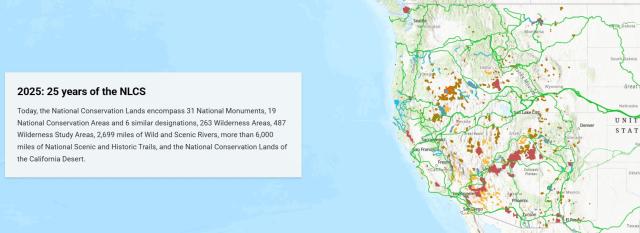
This year, the Bureau of Land Management celebrates the 25th anniversary of the National Conservation Lands. Established in 2000, this system of spectacular landscapes now includes 906 units which encompass more than 38 million acres. Designated by Congress and the President, these areas are conserved, protected, and restored for their natural beauty, historical value, cultural significance, and wealth of recreational opportunities.
To encourage people to discover, connect to, and explore these extraordinary places, the BLM launched three interactive story maps during National Great Outdoors Month. This annual month-long celebration in June encourages and inspires people to get outside and enjoy the great outdoors, making this a perfect time to experience the National Conservation Lands.
The About the BLM’s National Conservation Lands story map breaks down the mission, values, and components of the system, including National Monuments, National Conservation Areas, Wilderness, Wilderness Study Areas, Wild and Scenic Rivers, and National Scenic and Historic Trails. Deeply connected to their surrounding local communities, National Conservation Lands support recreational access, protect wildlife habitat, preserve cultural heritage, and provide economic benefits through tourism and myriad other uses. Collaborative decision-making with communities is essential to managing these lands and aligning with the BLM’s multiple-use, sustained yield mission.
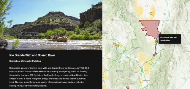
The Explore Your National Conservation Lands story map showcases the system’s diversity by highlighting 15 iconic locations and the unique values for which they were designated and protected. Also included is a link to the BLM National Recreation Mobile Map Package offering free, downloadable maps accessible to anyone and available offline.
The History of the BLM’s National Conservation Lands story map presents an interactive timeline tracing the system’s evolution from the 20th century to the present day. Demonstrating growth over time, it highlights key legislation passed by Congress, influential historical figures, and major milestones. Maps, photos, and other content offer a fascinating look at the origins and ongoing development of these protected public lands.
Haley Freeborn of the Western Colorado Conservation Corps developed these story maps during her internship with the BLM’s Division of National Conservation Lands. Together, the maps illustrate the system’s complex evolution, reflecting the BLM’s long-standing commitment to conservation within its mission of sustaining the health, diversity, and productivity of public lands for the use and enjoyment of present and future generations.
Related Stories
- Birding Aravaipa Canyon: A morning of songs, color, and creekside adventure
- Celebrating 2026 National Trails Day volunteers
- BLM law enforcement medical rescue team brings advanced care to public lands
- Boating Paradise: GAOA Funding Enhances Popular Recreation Site Along Montana’s Yellowstone River
- Meet Kyle Voyles, BLM National Cave and Karst Program Lead