
An Arctic eDNA eXTRAVAGANZA
Story and photos by Katie Drew, Fish Biologist – BLM
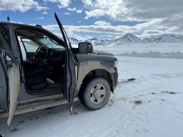
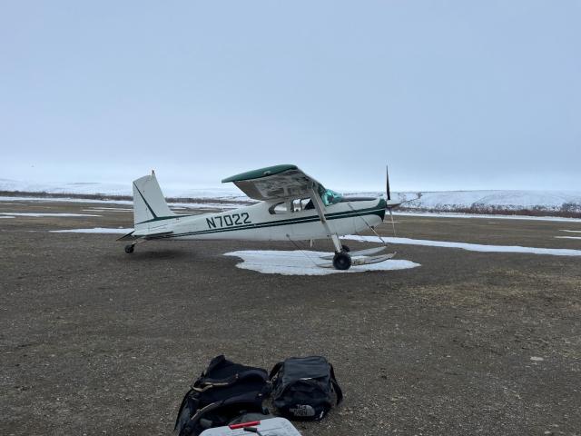
Departing from a cold, snow covered remote airstrip along the Dalton Highway by small, fixed wing aircraft, we were headed to the Bureau of Land Management (BLM) Arctic District’s Umiat Field Camp on the southeast edge of the National Petroleum Reserve in Alaska.
The BLM Arctic District Office manages the 23-million-acre National Petroleum Reserve in Alaska (known as the NPR-A). The NPR-A is the largest contiguous block of federal land managed by a single agency and is located between the Brooks Range and the Arctic Ocean in northern Alaska. The petroleum reserve provides for subsistence hunting and fishing for rural residents as well as significant oil and gas exploration and development activities. There are no permanent, year-round roads into the NPR-A, so aircraft and seasonally constructed snow and ice roads are required to access these lands.
During winter in the NPR-A, a network of ice roads are constructed to support oil and gas activities and facilitate transportation of equipment and consumer goods at reduced costs for rural communities. To construct ice roads, operators withdraw water and(or) harvest ice chips from lakes. This water/ice reinforces the road and helps create an armored surface to minimize impacts to the tundra. Before water withdrawals occur, operators must get permits for each water source they would like to use. The amount of water that can be withdrawn from lakes depends on two things: (1) lake depth and (2) fish species that are present. Lake depth is an important factor because ice can reach up to seven feet thick during winter. Generally, maximum lake depth must be greater than five feet to contain enough liquid water to support winter operations. The second consideration is whether fish species are present. To minimize impacts to overwintering fish and their habitats, lower quantities of water can be removed from lakes that support fish compared to those lakes without fish present.
To ensure that an accurate representation of the fish community is documented at each lake before water is removed during the winter, different combinations of traditional fishing gear (e.g., gill nets, fyke nets, minnow traps, etc.) are deployed during the summer or open water season. If fish are caught, this information is then used to help determine allowable water withdrawal volumes. Fish sampling is conducted during the summer because using traditional fishing gear during winter is generally considered impractical due logistics and costs associated with remote winter sampling. As a result, the overwintering distribution of fish is not well understood in the NPR-A.
That changed this past spring when the BLM traveled to the NPR-A to evaluate the use an innovative sampling approach, referred to as environmental DNA (eDNA), to assess if this technique could be used to help identify important overwintering areas.
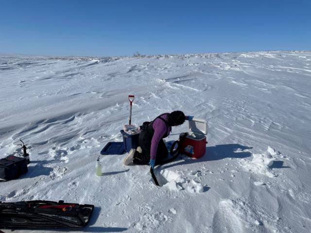
The term eDNA refers to DNA that organisms shed into the surrounding environment. For example, as fish swim they are constantly releasing DNA into the water as they shed skin or scales. By collecting and filtering water samples through a small filter specially designed for DNA capture, researchers can tell which species are present without having to set nets or even see the fish directly. This can be an efficient and cost-effective way to identity species that are present in a waterbody.
So, on an overcast, wintery day with flat light, we left Umiat and traveled by snowmachine with our field gear wrapped in tarps and strapped down in sleds. Navigating out of the Umiat Field Camp is often one of the more challenging parts of winter field work because of the numerous bluffs and river drainages that need to be crossed until you reach the flat, expansive coastal plain.
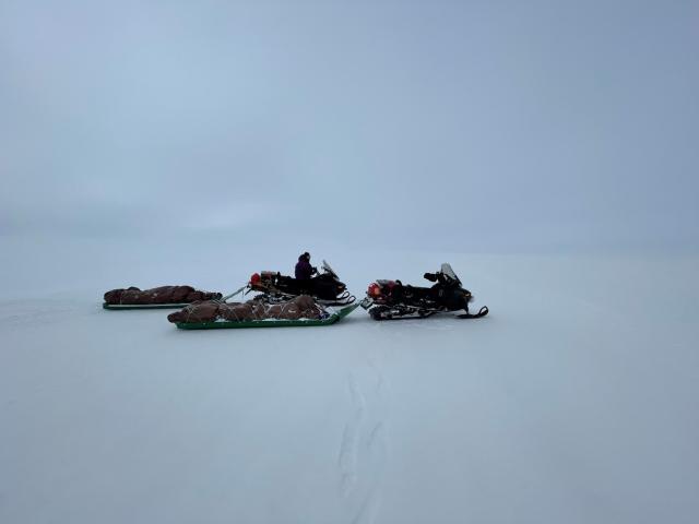
With no trail to follow, we made our own route guided by landscape terrain and GPS with the goal of collecting water samples from lakes permitted for water withdrawals.
Implementing the plan involved extensive logistics, including an 8 hour drive up the Dalton Highway to catch a fixed-wing flight from Galbraith Lake to the remote BLM Umiat Field Camp located along the Colville River. Once at Umiat we loaded up the snowmachines and traveled 50 miles to another remote BLM field camp, Inigok, that is located further north near the lakes we identified for sampling. The lakes targeted for this study have been surveyed using traditional fishing gear, so we had a good idea of the fish that use those lakes during the summer season.
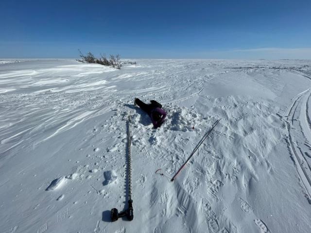
For 4 days, we traveled across the tundra by snowmachine, collecting water samples from 14 lakes as well as 3 nearby rivers. At each site, three holes were drilled through the ice using a drill-powered auger and two liters of water was filtered through a special filter using a SmithRoot citizen science eDNA sampler modified with a heated tube. The heated tube allowed us to filter the water in subzero temperatures without the water freezing. Then, we measured ice thickness, water depth, and snow depth at each location. We also used this opportunity to check on and download data from weather monitoring stations located in the area.
Once all the sites were sampled, we returned to the Umiat Field Camp to await a flight back to the Galbraith Lake airstrip where we would pick up the truck and drive back in Fairbanks. However, not all logistics go as planned on these types of trips, despite the extensive planning that goes into them. Due to weather conditions across the Brooks Range and persistent fog at Umiat, the plane was unable to pick us up for a couple days. That’s when it is beneficial to have several good books on hand to help pass the time.
After arriving back in Fairbanks, the eDNA filters were transferred into individual vials and kept frozen until processing. A few more months of lab work, and we submitted our samples for sequencing at the University of Alaska Fairbanks Genomics Lab. Once the results came back, we were able to see if we had successfully detected any overwintering fish…and we did! We detected nine fish species overwintering in lakes and rivers in the NPR-A, including broad whitefish and Arctic cisco, important subsistence species for the nearby community of Nuiqsut. Additional analyses are currently underway to help understand the landscape characteristics (e.g., lake depth, ice thickness, hydrological connectivity, etc.) driving fish distribution during winter and comparing these results to fish distributions during summer.
Given the relative ease of sampling and high sensitivity of the method, eDNA may be used in conjunction with traditional fishing gear to help document fish communities across the Arctic Coastal Plain, where high operational costs can otherwise limit monitoring efforts. Ultimately, this tool could help improve the BLM’s understanding of fish habitat use during winter and inform winter water use, ensuring the BLM fulfills its role of responsible energy development on public lands.
Related Stories
- Reel Partners: BLM and Wyoming Game and Fish Cast a Line for Kemmerer’s Next Generation
- Meet Dashiell Gould Lagoyda, fisheries biologist intern at the Safford Field Office
- Hooked on stewardship: Lake Havasu Field Office celebrates Fisheries Improvement Program volunteers
- BLM Colorado water rights specialist wins Riparian Hero Award
- A Paw-powered Legacy