
AIMing to understand dynamics of Arctic grayling in the Beaver Creek Wild and Scenic River
The Bureau of Land Management in Alaska manages approximately 111 river miles of the Beaver Creek Wild and Scenic River. This river winds through remote boreal forest of Interior Alaska, with its headwaters in the White Mountains National Recreation Area north of Fairbanks. The near pristine aquatic habitat in Beaver Creek contains concentrations of Arctic grayling important for recreational and subsistence uses.
To better understand habitat conditions and the population dynamics of this species, the BLM implemented a plan, the first of its kind in Alaska, to improve the BLM’s understanding of one of the outstandingly remarkable values – Arctic grayling – for the Beaver Creek Wild and Scenic River. This plan relied heavily on enthusiastic partners and Assessment, Inventory and Monitoring strategies more commonly known as AIM and is expected to aid the Bureau in refining its national assessment methods for boatable rivers under the AIM program.
In essence, AIM strategy provides a standardized approach for measuring natural resource conditions and trends on BLM-managed public lands. The AIM strategy provides quantitative data and tools to guide and justify policy actions, land uses, and adaptive management decisions.
Despite Beaver Creek’s designation through the Alaska National Interest Lands Conservation Act in 1980 as a wild and scenic river, BLM possesses a small amount of information regarding the habitat conditions and population status or trends of Arctic grayling throughout the river. However, BLM staff continue their tremendous progress in developing and implementing wadeable stream monitoring methods to better capture the necessary data.
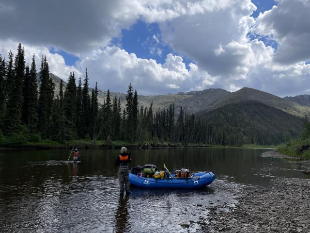
Understandably, large rivers like Beaver Creek, can pose significant sampling and logistic challenges compared to wadeable streams. These challenges can make it difficult to capture necessary data to monitor the Arctic grayling species, their habitat and population. Recognizing a biological data gap with respect to Arctic grayling and the scarcity of consistent habitat data across the river, BLM fisheries biologist Christopher Clark developed a phased approach to address these data issues. This two phased approach partnered with Alaska Department of Fish and Game to address Arctic grayling population dynamics (seasonal movement and abundance) and leverages BLM investment and progress in their AIM to assess baseline habitat conditions throughout the river. With a draft protocol in hand for monitoring non-wadeable rivers Clark and team set out to begin closing the data gap.
Working in Alaska, implementing the plan wasn’t easy given the remote logistics and helicopter support needs. Phase one involved the surgical implantation of radio tags in 149 grayling (tag 150 forever lost) to monitor monthly movement for two or more years. This aspect of the project involved 10 continuous long days on the river hook and line sampling respectively covering 110 miles to meet the established fish abundance and size sampling requirements.
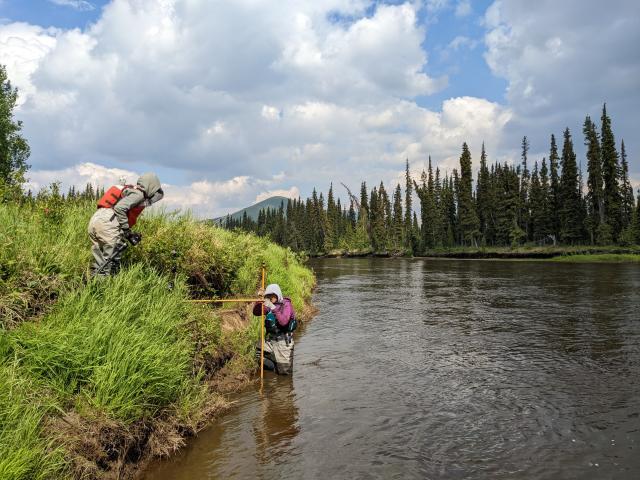
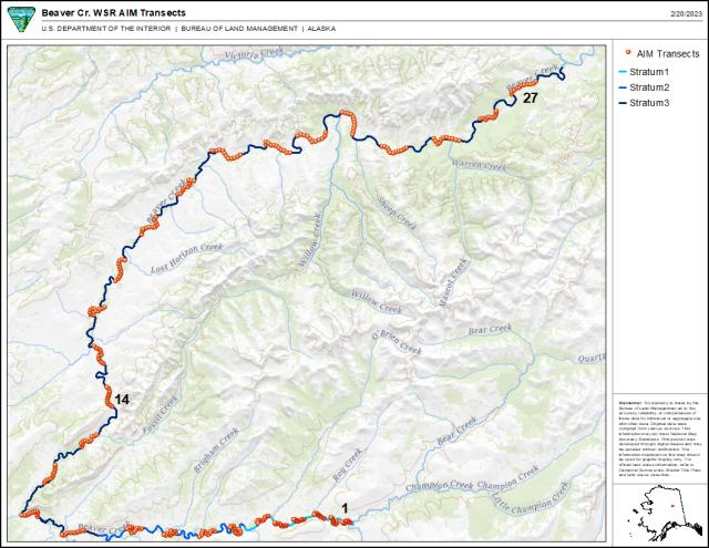
Phase two of the project posed major obstacles given the limited BLM staff in Alaska to support field data collection. To fulfill two well-trained sampling teams, Clark leveraged staff from other BLM offices, and federal agencies including the National Park Service, U.S. Fish and Wildlife Service and the Alaska Department of Fish and Game. Each of the two teams completed data collection across 14 stream segments (based on statistically robust sampling designs). One team was responsible for assessing the upper 40 miles which can be characterized as a multi-thread channel with a narrower valley bottom. The other team was tasked with assessing the lower 75 miles of the river which was more of a single thread wide valley bottom setting. Currently, Clark is working through the habitat data while the Alaska Department of Fish and Game analyzes the fish tracking data in preparation for a capture-mark-recapture study (commonly referred to as mark-recapture), to understand population status and trend. Mark-recapture studies are widely used in ecology from lizards, snails, fish, cheetahs and everything in-between and have a long history as they allow researchers to estimate population sizes and population vital rates (survival, movement, growth). As the name of the technique implies, individuals of a population are first captured then marked (visible tag, brand, electronic tag, etc.) and then released back into the wild. Then researchers head back out for a “recapture” event where they tally the number of fish they “capture” that have a mark and those that do not. These proportions are then used to estimate population size.
The collaborative partnership was essential to the overall project implementation and success. A success that isn’t limited to the BLM. In fact, the NPS and the Alaska Department of Environmental Conservation are leveraging the success of the Beaver Creek project to inform sampling efforts of other non-wadeable rivers across Alaska and look to collaborate with BLM on these efforts.
BLM Alaska manages 89% of all stream and riverine habitats (175,660 miles) in the Bureau with a program staff comprised of nine fisheries biologists, six hydrologists, and a geomorphologist. AIM-based inventory and monitoring approaches are essential to understanding the condition and trends of these important aquatic resources, which include 953 miles of river habitats associated with six designated wild and scenic river units. Innovation, ingenuity, and collaboration by members of the Alaska team on Beaver Creek help to ensure that the BLM is prepared to meet its mission of understanding the condition and trend of aquatic resources for current and future generations.
Related Stories
- Meet Dashiell Gould Lagoyda, fisheries biologist intern at the Safford Field Office
- Hooked on stewardship: Lake Havasu Field Office celebrates Fisheries Improvement Program volunteers
- BLM Colorado water rights specialist wins Riparian Hero Award
- A Paw-powered Legacy
- Defending public lands: Combating invasive species in BLM Eastern States
Office
222 W 7th Avenue #13
Anchorage, AK 99513
United States