
New Year, New Adventures in Utah!
Did your New Year’s resolution include more adventures outdoors? We will be spotlighting some great locations across Utah for you to explore on your next outdoor adventure! Please recreate responsibly when visiting public lands managed by the Bureau of Land Management. For tips on how to recreate responsibly during the winter, visit our Instagram account to learn more!
Color Country District
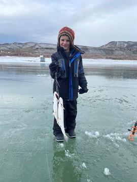
Ice fishing
Location: Otter Creek Reservoir - Near Antimony, Utah
Ice fishing is a favorite pastime for many anglers at Otter Creek in Richfield, Utah. So as temperatures drop, it’s time to break out the jigs, augers, and crampons and visit this angler’s paradise. The cold, clear water of this large reservoir offers great fishing for rainbow trout. The Richfield Field Office manages day-use facilities, dispersed and primitive camping facilities, and fishing access to the Reservoir at Fisherman's Beach, Tamarisk Point, and South Point along the west side of the reservoir.
The Richfield Field Office maintains several semi-primitive campsites along the west side of the lake. Dispersed use is available on the east side of the reservoir. Visit Recreation.gov to find your next adventure at the Otter Creek Reservoir Recreation Area!
Canyon Country District
Biking and Hiking
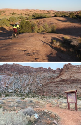
Location: Slickrock Trail - Near Moab, Utah
The famous Slickrock trail in Sand Flats Recreation Area crosses a scenic and rugged expanse of rolling Navajo Sandstone, the remnant of an ancient desert environment of wind-blown sand dunes. Originally established in 1969 for motorcycles, the trail has become a popular destination for mountain bikes. The trail is open to both motorcycles, mountain bikes, and hiking. It is often accessible year-round since most of the trail covers sandstone rock faces and receives lots of sunlight throughout the day. Hikers can also enjoy this trail all year round. The recreation area is comanaged by the Bureau of Land Management and Grand County.
Location: Pipe Dream and Hidden Valley Trails - Near Moab, Utah
These two trails begin at the same trailhead and parking area. Visitors who attempt the steep Hidden Valley Trail are rewarded with great views of Moab and entry into a small valley that gives the allusion of being far away from civilization and other visitors. The Pipe Dream trail system (created in 2010) is the closest trail system to Moab. Pipe Dream is a challenging trail with very narrow, steep corners and many areas with exposures. The Pipe Dream Trail is used by hikers and bikers and has maps and signs at every junction. These trails are close to Moab and often snow-free; however, it is still important to be prepared. Bring layers of clothing to help you stay comfortable in changing temperatures and conditions. Don’t forget your sun protection and water. Even if it isn't hot, your body still needs protection from the sun and water to keep hydrated. Watch out for slippery and/or icy conditions. Wear the appropriate footwear and keep an eye out for uneven or wet ground.
Green River District
Hiking
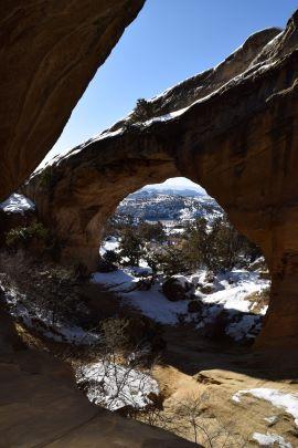
Location: Moonshine Arch Trailhead - Near Vernal, Utah
Tucked away in the Weber sandstone formation at the base of Red Mountain near Vernal, Moonshine Arch during the winter season can feel like you are inside a natural snow globe. Shake things up by visiting this winter wonderland for hiking and watch the snow settle in this hidden cove! Moonshine Arch Trail is a multi-use trail that is open to off-highway vehicles (OHVs), bikes, hikers, equestrians, and leashed dogs. Please respect private land ownership by only parking in the suggested areas and by staying on designated routes.
Paria River District
Photography, Star Gazing, and Hiking
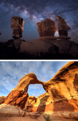
Location: Devil’s Garden - Garfield County, Utah
Be it sunrise, sunset or sitting beneath the Milky Way under a clear dark sky for what seems like forever in terms of distance, Devil’s Garden is a photographer's dream. It is hard to capture an unflattering selfie in this wonderland of sandstone hoodoo formations and natural arches. As a part of the Grand Staircase-Escalante National Monument, Devil’s Garden offers outstanding opportunities for hiking, geological sightseeing, and photography.
Related Stories
- Birding Aravaipa Canyon: A morning of songs, color, and creekside adventure
- BLM, Partners Enhance Public Access at Popular Recreation Area
- Framed for Freedom: Bureau of Land Management Eastern States and the Legacy of National Historic Trails
- BLM Celebrates America’s 250th Anniversary in Oregon
- Reel Partners: BLM and Wyoming Game and Fish Cast a Line for Kemmerer’s Next Generation
Office
440 West 200 South, Ste. 500
Salt Lake City, UT 84101
United States