
St. George Basin Travel Management Area Map
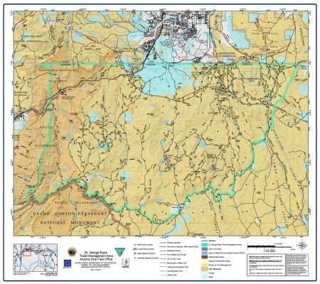
This free, downloadable georeferenced PDF map covers the St. George Basin Travel Management Area (TMA) in the Arizona Strip.
The St. George Basin TMA encompasses a large expanse of BLM-managed public lands in the northwestern Arizona Strip, south and west of St. George, Utah. The St. George Basin TMA boundary is shown on the map. The map uses color-coding to show which agency manages each parcel of land within and surrounding the travel management area.
BLM route numbers, county road numbers, state highway numbers, and interstate highway numbers are labeled on the map. Historic trails shown on the map include the Old Spanish National Historic Trail (Armijo Route), the Dominguez and Escalante Historic Trail, the Temple Historic Trail, the Jedediah Smith Historic Trail, and the Sullivan Canyon Trail. The Paiute Trail is also shown. The Mojave Desert Joshua Tree Road Scenic Backway is shown in the southwestern portion of the map.
Named springs shown on the map include Atkin Spring, Black Rock Spring, Clay Spring, Cottonwood Spring, Cougar Spring, Coyote Spring, Fort Pearce Spring, Gates and Mullen Spring, Hancock Spring, Little Wolf Spring, Locust Spring, Maple Spring, Mountain Sheep Spring, Mustang Spring, Oak Spring (two locations), Pocum Spring, Quail Spring, Quaking Aspen Spring, Ruesch Spring, Sand Spring, Seegmiller Spring, Seep Spring, Sullivans Spring, Tombstone Spring, Val Cedar Spring, Val Pearce Spring, Virgin River Spring, West Mountain Valley Spring, Well Spring, and Wolf Hole Spring.
Named peaks and landmarks include Beacon, Bloomington Hill, Bulldog Knolls, Bulldog Pass, Cougar Spring, Dinosaur Tracks, Jarvis Peak, Joe Blake Hill, Little Black Mountain, Low Mountain, Mount Bangs, Seegmiller Mountain, Warner Ridge, Webb Hill, and Yellow Knolls.
Named canyons, washes, and valleys include Atkinville Wash, Big Valley, Black Purgatory, Box Canyon, Bulldog Canyon, Cottonwood Canyon, Dutchman Draw, Fort Pearce Wash, Honeymoon, Hurricane Cliffs, Lizard Wash, Main Street Valley, Mokaac Wash, Pearce Wash, Pocum Cove, Rock Canyon, Sand Mountain, Sullivan Canyon, Virgin River Canyon, Water Canyon, Wolf Hole, and Wolf Hole Pass.
Points of interest shown on the map include the Black Rock Fire Tower, Dinosaur Tracks, Fort Pearce, Gardner Well, Gaging Stations, Low Mountain Comm Site, Public Lands Information Center, Railroad Trestle Bridge, Seegmiller Mountain Comm Site, Stateline Fish Barrier and Gaging Station, St. George Municipal Airport, Sunshine Trail Access, and the Webb Hill Fish Barrier. The Virgin River Canyon Recreation Area is also shown.
The Sand Mountain Open OHV Area is shown in gray in the northeastern portion of the map near Hurricane, Utah. The Mokaac Trail Open OHV Area is also shown on the map.
Nine Areas of Critical Environmental Concern (ACEC) are shown on the map. The ACECs shown are Beaver Dam Slope ACEC, Black Knolls ACEC, Ft. Pearce Wash ACEC, Lower Virgin ACEC, Red Bluff ACEC, Stateline ACEC, Virgin Slope ACEC, Warner Ridge – Ft. Pearce ACEC, and Webb Hill ACEC.
The Apex Mine and Warner Beacon Mine are shown on the map. Water tanks and corrals are labeled throughout the map area.
This map was produced on Jan. 29, 2021. The map number is 2003-01-01. The scale is 1:65,000 using the Lambert Conformal Conic projection. The datum is North American 1983 with a contour interval of 100 feet.
Travel routes depicted on this map across Arizona State Trust Lands or private lands do not imply legal public access to use or cross those lands. Any public use of State trust lands is strictly under the jurisdiction of the Arizona State Land Department and use of private lands requires permission of the land owner. All users must comply with State policies and regulations and private land owner rights in order to legally use or traverse non-BLM lands.
No warranty is made by the Bureau of Land Management as to the accuracy, reliability, or completeness of these data for individual use or aggregate use with other data. Original data were compiled from various sources. This information may not meet National Map Accuracy Standards. This product was developed through digital means and may be updated without notification.