
SARA Park Trail Map
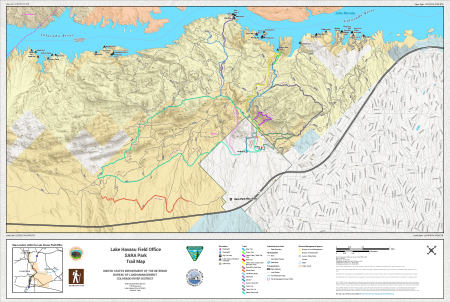
This free, downloadable georeferenced PDF map shows trails, campsites, and recreational areas at SARA Park near Lake Havasu City, Arizona, that are managed by the Bureau of Land Management (BLM) Colorado River District Lake Havasu Field Office.
Key features of this map include:
- The SARA Park Recreation Area is shown and labeled on the map.
- The map shows 15 non-motorized trails. Each trail is color-coded on the map. The trails shown are the Blue Trail, Green Trail, Lizard Peak / Table Top Trail, Red Trail, Yellow Trail (also known as the Crack-in-the-Mountain Trail), Downhill to Red Rock, Ghost Road, Old Mining Road, Pilot Rock, Send It!, Sonny's Downhill, Trash Can, Trash Can Lid, and Watershed Loop Trail. There are no motorized trails or primitive roads depicted on this map.
- Multiple named campsites are shown along the Colorado River and Lake Havasu shoreline, including Road Runner 1, Road Runner 2, Friendly Isle 1, Friendly Isle 2, Friendly Isle 4, Sandy Isle 1, Sandy Isle 2, Sandy Isle 3, Mallard Cove 5, Mallard Cove 6, Steamboat Cove 1, Steamboat Cove 2, Steamboat Cove 3, Bluebird 1, Widgeon Key, Wren Cove 1 (ADA Accessible), Wren Cove 2 (ADA Accessible), Wren Cove 3, Goose Bay 1, Goose Bay 2, Pilot Rock 1, Pilot Rock 2, Pilot Rock 3, Eagle Point, Balance Rock Cove, Buzzard Cove, Solitude Cove, Rachel's Camp, Linda's Camp, and Ewe Camp. A designated day use site is also shown.
- Two vehicle parking areas are shown on the map: Parking #1 and Parking #2.
- The Colorado River is shown along the northern and western edges of the map. Seasonal intermittent stream channels are also shown. Lake Havasu is shown in blue along the northeastern portion of the map.
- Land management by agency for the area surrounding SARA Park is shown on the map.
This map was produced by Lake Havasu Field Office staff on May 19, 2026. The map number is AZ-REC3010-01-02. The scale is 1:3,750,000 using the NAD 1983 UTM Zone 12N coordinate system. The Arizona Reference System is U.S. PLSS GSR and the California Reference System is U.S. PLSS SBM.
Contact the Lake Havasu Field Office at 1785 Kiowa Avenue, Lake Havasu City, AZ 86403, by phone at 928-505-1200, or by email at [email protected].
Travel routes depicted on this map across Arizona State Trust Lands or private lands do not imply legal public access to use or cross those lands. Any public use of State trust lands is strictly under the jurisdiction of the Arizona State Land Department and use of private lands requires permission of the land owner. All users must comply with State policies and regulations and private land owner rights in order to legally use or traverse non-BLM lands.
While every effort has been made to ensure the quality of the information presented, the Bureau of Land Management (BLM) makes no warranty regarding the accuracy or completeness of this map. This map and data are representational and are to be used as intended by the BLM. Map data are compiled from various sources. This map and the data from which it was derived are not binding on the BLM and may be revised at any time.