
Cerbat Foothills Recreation Area Map
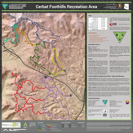
This free, downloadable georeferenced PDF serves as both a detailed trail map and a visitor brochure for the Cerbat Foothills Recreation Area (CFRA) near Kingman, Arizona. The 11,300-acre area is a mixture of federal, state, county, city, and private lands cooperatively managed by the City of Kingman and the BLM under a management plan approved in 1995.
Eight color-coded trails are shown on the map. Segment mileages are labeled along each trail. The trails and their total lengths are:
- Badger Trail: 3.18 miles
- Castle Rock Trail: 6.10 miles
- Rattler Trail: 4.97 miles
- Sidewinder Trail: 3.29 miles
- Camp Beale Loop Trail: 3.27 miles
- Foothills Rim Trails: 10.3 miles
- Monolith Gardens Trails: 9.54 miles
- Camp Beale-Monolith Connector Trail: 1.53 miles
Trailhead locations, parking areas, restrooms, and scenic overlooks are shown on the map. Four trailheads are marked: Metwell, Coyote Pass, Badger, and Camp Beale Loop.
Highways and minor routes are also shown on the map. Interstate 40, US-93, and State Route 68 are shown for geographic reference.
In addition to a map, it also contains user guidelines, safety and weather information, trailhead access directions, area history, wildlife, vegetation, grazing, and contact information.
This was produced on June 11, 2019, and updated on November 15, 2019. The scale is 1:10,000. Data sources include the Bureau of Land Management, Arizona State Lands Department, United States Census Bureau, United States Geological Survey, and Mohave County.
For questions, contact the BLM Kingman Field Office at 2755 Mission Blvd, Kingman, AZ 86401, by phone at 928-718-3700, or by email at [email protected]. This trail system can also be found on the Arizona State Parks and Trails website. For City of Kingman parks and recreation information, contact the City of Kingman Parks and Recreation Department at 310 N Fourth St, Kingman, AZ 86401, by phone at 928-757-7919, or visit the city's website.
The BLM makes no representations or warranties regarding the accuracy or completeness of this map. This map does not address questions which an accurate survey may disclose. This map is representational and is to be used as an illustration only. This map and the data from which it was derived are not binding on the BLM and may be revised at any time in the future. The BLM shall not be liable under any circumstances for any damages with respect to any use of this map or the data from which it was derived.
Georeferenced maps are not a substitute for proper preparation and knowledge to travel on public lands. Please check with your local BLM office for the most up-to-date information and conditions. Routes depicted on non-BLM lands are displayed for information purposes only and do not grant access to non-BLM lands.