


Arizona Herd Management Areas Map
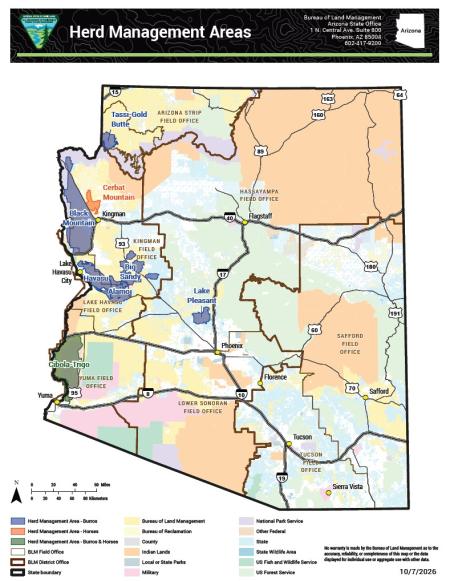
Map of Arizona showing wild horse and burro herd management areas (HMA). Burro HMAs are marked in blue. Burro HMAs include Tassi-Gold Butte, Black Mountain, Big Sandy, Havasu, Alamo in western Arizona, and Lake Pleasant in central Arizona north of Phoenix. The Cerbat Mountain HMA north of Kingman and is marked in orange, which indicates a horse-only HMA. The Cibola-Trigo HMA is in green, indicating burros and horses, and is north of Yuma along the Colorado River. The map also shows field office boundaries, interstate and U.S. highways, and major cities.
Cities are shown with a circle symbol. The district office boundary is shown with a heavy dark brown line. The field office boundary is shown in a light brown line.
U.S. highways are shown as solid black lines. Interstates are shown as a gray and black line.
The map also shows land management by agency across Arizona, including BLM, Bureau of Reclamation, County, Indian Lands, Local or State Parks, Military, National Park Service, Other Federal, State, State Wildlife Area, U.S. Fish and Wildlife Service, and U.S. Forest Service.
Contact the Arizona State Office at 1 N. Central Ave, Suite 800, Phoenix, AZ 85004, or call 602-417-9200.
The date of production is Oct. 7, 2026.