
Arizona Surface Management Map
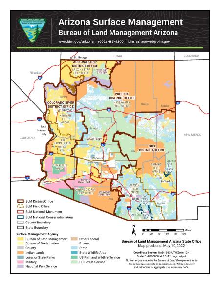
This free, downloadable PDF map shows who manages the land across the state of Arizona. Every parcel of land in Arizona is color-coded by the agency or entity responsible for managing it, from federal agencies like the Bureau of Land Management and the U.S. Forest Service to state, tribal, private, and military lands.
- Bureau of Land Management lands are shown in dark yellow and represent all public lands in Arizona managed by the BLM.
- Bureau of Reclamation lands are shown in light yellow and represent lands managed by the U.S. Bureau of Reclamation.
- County lands are shown in light gray and represent lands managed by Arizona counties.
- Indian lands are shown in orange and represent tribal nations and Native American lands across Arizona.
- Local or state parks are shown in dark teal and represent parks managed by Arizona state or local governments.
- Military lands are shown in pink and represent lands managed by the U.S. Department of Defense, including military installations and training areas.
- National Park Service lands are shown in purple and represent national parks, monuments, and recreation areas managed by the NPS.
- Other federal lands are shown in brown and represent lands managed by other federal agencies not listed separately.
- Private lands are shown in white and represent privately owned land.
- State lands are shown in light blue and represent lands managed by the Arizona State Land Department.
- State wildlife areas are shown in teal and represent lands managed by the Arizona Game and Fish Department.
- U.S. Fish and Wildlife Service (USFWS) lands are shown in dark blue and represent national wildlife refuges and other lands managed by the USFWS.
- U.S. Forest Service (USFS) lands are shown in light green and represent national forests and grasslands managed by the USFS.
In addition to surface management, the map also shows BLM district and field offices as well as national monuments and national conservation areas.
The map was produced by the BLM Arizona State Office on May 10, 2022, using the NAD 1983 UTM Zone 12N coordinate system at a scale of 1:4,000,000 for standard 8.5×11-inch page output.
For questions, contact the BLM Arizona State Office by phone at 602-417-9200 or by email at [email protected]. You can also contact the BLM office that manages the area you plan to visit.
No warranty is made by the Bureau of Land Management as to the accuracy, reliability, or completeness of these data for individual use or aggregate use with other data.