
Kasha-Katuwe Tent Rocks National Monument | New Mexico
Entry into the monument is by reservation only, Thursdays through Mondays between 8:00 a.m. and 1:00 p.m. Visitors are asked to exit the monument by 4:00 p.m. Visitors may make reservations at Recreation.gov for dates through September 28, 2026. Please check Kasha-Katuwe Tent Rocks National Monument webpage for future ticket release dates.
The Kasha-Katuwe Tent Rocks National Monument is a remarkable outdoor laboratory, offering an opportunity to observe, study, and experience the geologic processes that shape natural landscapes. The National Monument, on the Pajarito Plateau in north-central New Mexico, includes a national recreation trail and ranges from 5,570 feet to 6,760 feet above sea level. It is for foot travel only, and contains two segments that provide opportunities for hiking, birdwatching, geologic observation, and plant identification.
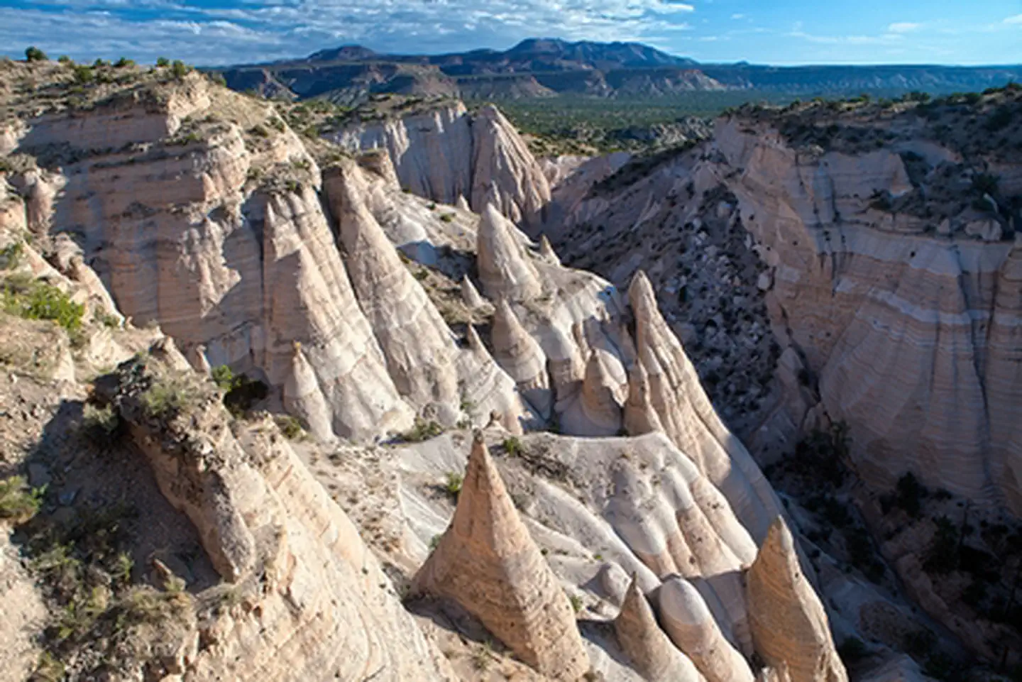
The cone-shaped tent rock formations are the products of volcanic eruptions that occurred 6 to 7 million years ago and left pumice, ash, and tuff deposits over 1,000 feet thick. Tremendous explosions from the Jemez volcanic field spewed pyroclasts (rock fragments), while searing hot gases blasted down slopes in an incandescent avalanche called a pyroclastic flow.
Precariously perched on many of the tapering hoodoos are boulder caps that protect the softer pumice and tuff below. Some tents have lost their hard, resistant caprocks, and are disintegrating. While fairly uniform in shape, the tent rock formations vary in height from a few feet up to 90 feet.
Please note that dogs are not allowed in the Monument.
Photos
Accessibility Description (ABA/ADA)
- There are ADA compliant rest rooms, picnic facilities, kiosks, and parking.
- The Cave Loop Trail is 1.2 miles long and is rated as easy.
- While the trail is gravel/sand and some portions are moderately flat, wheelchair use may be difficult.
- At the Veterans' Memorial Overlook you will find ADA-accessible picnic areas, rest rooms, trails and facilities.
- This trail is gravel and flat but may not be conducive to wheelchair use.
Plan your Visit (Hours & Fees)
Visitation to the Monument is by reservation only through www.recreation.gov. Visitors are encouraged to plan ahead and make reservations early as tickets are limited.
All visitors must check in at the Cochiti Visitor Center prior to entry into the Monument. Check in begins no earlier than 7:45 a.m. with pilot vehicles leading visitors into the Monument starting at 8:00 a.m. The last pilot car will leave the Cochiti Visitor Center at 1:00 p.m. All visitors must exit the Monument by 4:00 p.m.
The Monument is open Thursday through Monday, and will be closed the following days:
- Friday before Easter
- Saturday before Easter
- Easter Sunday
- Monday after Easter
- May 3
- July 13 and 14
- July 25
- Nov. 1
- Thanksgiving Day
- Dec. 15 – Jan. 31 (seasonal closure)
The Monument may also be closed for no more than three additional cultural days identified by the Pueblo. The BLM asks the public to respect our neighbors and their traditions during culturally significant times. Much of the area that surrounds the Monument is Tribal property. Federal and local law enforcement personnel will patrol the area and notify authorized personnel of any trespass issues.
Visitation to the Monument is by reservation only through www.recreation.gov. Visitors are encouraged to plan ahead and make reservations early as tickets are limited. Reservation transactions now include an administrative fee of $1.00 per ticket for all visitors in addition to the reservation fee, raising the total fee for BLM Ticket Reservations from $5.00 to $6.00 per person. Youth tickets and tickets reserved using America the Beautiful/Interagency Passes are not excluded from the administrative fee and will cost $1.00 per ticket.
Cochiti Pueblo Tribal Access Pass:
Visitors must obtain a Cochiti Pueblo Tribal Access Pass directly from the Pueblo prior to entering the Monument. The cost per visitor is $20/person over age 16; $10/person 2-16 years old; and free for visitors under 2 years old. A direct link to Cochiti Pueblo Tribal Access Pass will be provided during the Recreation.gov transaction.
The Cochiti Pueblo Tribal Access Pass and the BLM Ticket Reservation are separate, and visitors must have both permits to access the Monument. Interagency Passes cannot be used to waive the fees for a Cochiti Pueblo Tribal Access Pass.
For more information, please contact the BLM Rio Puerco Field Office front desk at 505-761-8700 or the Cochiti Pueblo at 505-624-4284 or 505-584-9652.
Trail Information
Kasha-Katuwe Tent Rocks Trail Guide
- The Monument includes a national recreational trail. It is for foot travel only, and contains two segments that provide opportunities for hiking, birdwatching, geologic observation, and plant identification. Both segments of the trail begin at the designated Monument parking area.
- The Cave Loop Trail is 1.2 miles long, rated as easy. The more difficult Canyon Trail is a 1.5-mile, one-way trek into a narrow canyon with a steep (630-ft) climb to the mesa top for excellent views of the Sangre de Cristo, Jemez, Sandia mountains and the Rio Grande Valley. Both trails are maintained; however, during inclement weather the canyon may flash flood and lightning may strike the ridges.
- The Veterans’ Memorial is located at the end of a 3-mile-long gravel surfaced road overlooking picturesque Peralta Canyon and Jemez Mountain peaks. Picnic tables, shelters and toilets are available at both sites.
- The Veterans' Memorial Trail is a 1-mile-long loop trail, rated as easy. This trail is gravel and flat but may not be conducive to wheelchair use.
Prohibitions and Restrictions
- Visitation by reservation only through Recreation.gov.
- For the health and safety of all visitors, please leave dogs and drones at home. Identifiable service animals are welcome.
- Day Use Only
- No open fires, shooting, alcoholic beverages, glass containers, or climbing on the "tent rocks."
- Do not trespass on Tribal, private, or state land.
- Access to the Monument may be closed by order of the Cochiti Tribal Governor. Closures will be posted at the gate.
- No motorized vehicles or mountain bikes are allowed.
- Protect live trees and shrubs. You may not cut green trees or firewood without a permit.
- No collecting of plants, rocks, obsidian "Apache tears," or wildlife.
- Please stay on designated roads and trails.
- Geocaching is prohibited.
- Do not feed the wildlife
- Hunting and recreational shooting is not allowed in the Monument.
Brochures, Maps, and Publications
- Kasha-Katuwe Tent Rocks Trail Guide
- Interactive Map
- Printable Map
- Plant Guide
- Bird Guide
- Junior Ranger Activity Guide
Rocks Rock! Hit the Trails Learning Education Initiative
Contact Us

Activities


Addresses
Directions
All visitors must check-in at the Cochiti Visitor Center prior to entry into the Monument. Please be sure to make your first stop at the Visitor Center and wait for a pilot vehicle prior to entering the Monument.
- From Albuquerque & Santa Fe on I-25, take the Cochiti Pueblo Exit 264 off I-25 onto NM 16. Turn right off NM 16 onto NM 22, and turn right into the Cochiti Visitor Center for check-in.
- Note, following the GPS coordinates may take you through Tribal lands that are not accessible. Please follow the directions above and access the Monument from I-25.
Fees
Visitation to the Monument is by reservation only through www.recreation.gov.