
Defensive Sites of Dinetah | New Mexico
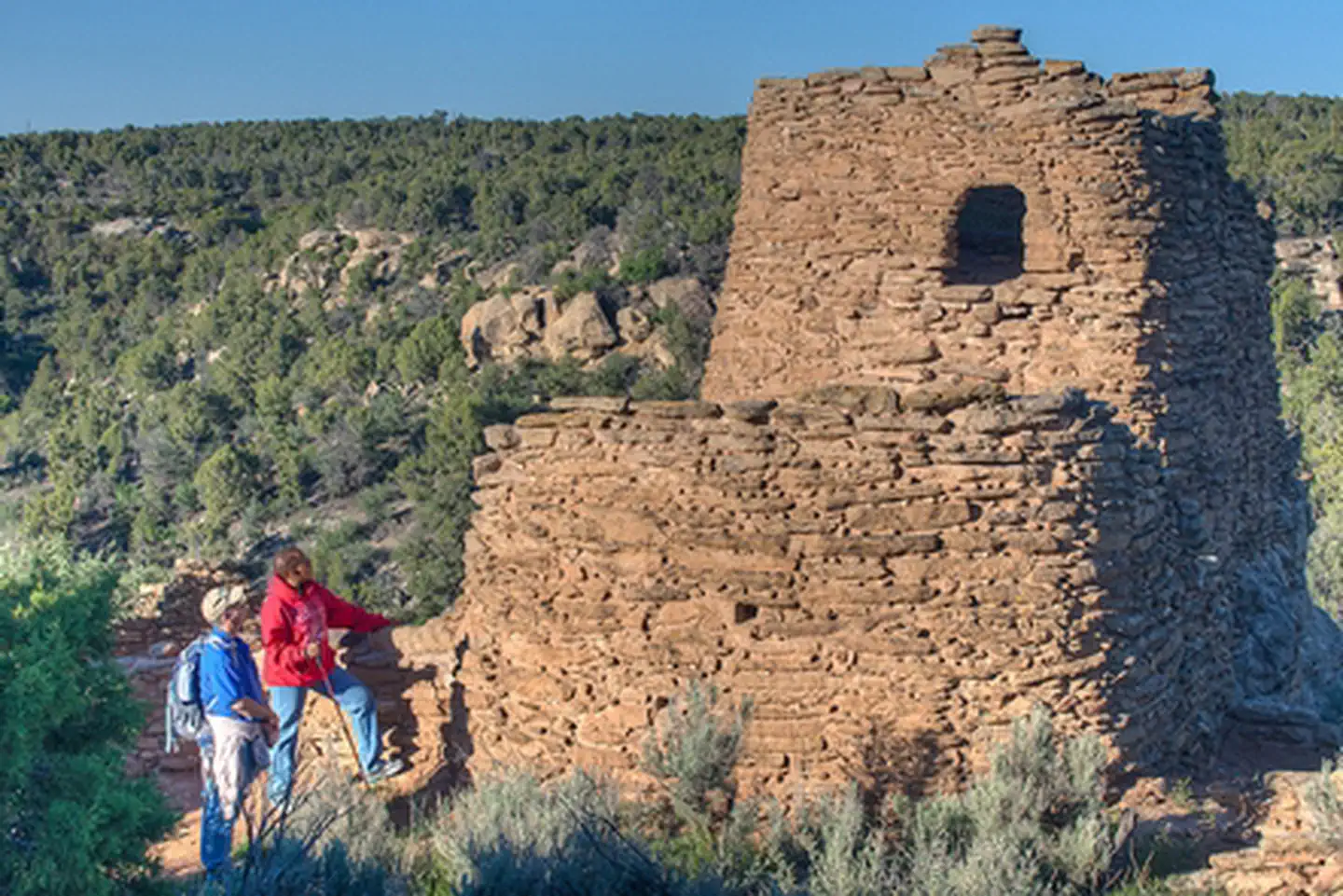
The small, aboveground masonry structures of northwestern New Mexico called "pueblitos" (Spanish for "little pueblos") drew the attention of the first European visitors to this area centuries ago. The pueblitos were observed by Spanish travelers in the early to mid-1700s, who remarked that they were places of defense against the Utes and Comanches. The early 20th century residents of the Gobernador area used the term pueblitos in reference to these small stone structures. In the early 1900s, the noted archaeologist Alfred Kidder proposed that these structures might have been built by Puebloan refugees fleeing Spanish reprisals after the Spanish resettlement of New Mexico in 1692, although research since then has well established that most, if not all, of the pueblitos were constructed by the Navajo (Diné).
These "Pueblitos of Dinétah" (pueblitos in the homeland of the Diné) were constructed in the 17th and 18th centuries and used defensively as well as for shelters and cooking. They are often situated on large boulders or outcrops, allowing the residents to have maximum vantage points. Architectural elements include roofs, hooded fireplaces, hogan foundations as well as peep holes for doorway security.
Pueblitos under the jurisdiction of the Bureau of Land Management include Simon Canyon Ruin, Tapacito Ruin, Split Rock Ruin, Frances Canyon Ruin, Hooded Fireplace Ruin, Largo School Ruin, and Crow Canyon Site. All of these sites were listed on the National Register of Historic Places in 1974 and 1987.
Photos
Accessibility Description (ABA/ADA)
All sites have either a dirt parking area or pull-off marked with a nearby trailhead, these parking areas are not maintained by the BLM, park at your own risk. Most of the trails are short, but overgrown and uneven with one or two interpretive signs.
- To navigate these trails, visitors will need to walk across uneven dirt, through weeds, and travel for up to two miles to reach the various defensive sites.
Know Before You Go
Fees
None.
Facilities
There are no restrooms or potable water available at any of these sites.
Several sites have rough dirt pull-offs and short trails that leads to the ruins if possible.
Parking alongside the road or in the pull-offs is done at one’s own risk as these are not maintained by the BLM.
Nearby Amenities
The nearest location to acquire gas, food, and water is in Bloomfield, ~30 - 50 miles away via Co Rd 379 (Sullivan Rd 4450) depending on the site you are leaving from.
Season/Hours
Open year-round.
Roads may become impassable during or after inclement weather.
Special Rules
Motorized use of the trails is prohibited.
No fireworks, discharge or use of firearms, or any other weapons at any of the Defensive sites.
The Antiquities Act of 1906 and the Archeological Resources Protection Act of 1979 make it illegal to excavate, remove, damage, or deface archaeological resources. Penalties of up to five years in jail and a $250,000 fine can be imposed.
Collecting historical or archaeological artifacts from the area is not allowed.
Pets must be on a 6-foot leash and their waste disposed of.
Practice Leave No Trace. Please make sure to carry out or dispose of any litter.
Wildlife in Area
Jackrabbits
Coyotes
Turkey vultures

Contact Us

Activities


Directions
Simon Canyon Ruin
Simon Canyon Ruin can be reached by driving to the parking lot and picnic area for Simon Canyon Recreation Area, located on the north side of the San Juan River, 3.5 miles below Navajo Dam. A moderate half-mile hike leads to the site.
Frances Canyon Ruin
To access the site, take NM Hwy 527 north from US 64 to mile marker 11, and turn left (west). Follow the road to the mesa top. Continue to follow the road to a "T" intersection approximately 2.5 miles from the base of the mesa. Turn right (south) and continue an additional 0.5 miles, then keep left at the Y-intersection, continue about 400 feet, then turn left (northeast), and follow the pipeline about 0.2 miles to the parking area. A short, gentle hike leads to the site.
Crow Canyon
To reach the petroglyphs, a high-clearance, four-wheel drive vehicle is recommended. Take County Road 4450 for 19 miles south from its junction with Highway 64. Follow the signs across Largo Wash, and then turn north and drive approximately one mile to the mouth of Crow Canyon. (NOTE: Do not cross either wash when water is present, and caution should be used when sand is either very wet or very dry. Get out of your vehicle to check the condition of the wash). Signs direct you to the main panels at the mouth of the canyon. To see the "44 Panel," follow the road up the canyon, and then park at the well pad. Signs direct you to the trail to the "44 Panel," a hike of about 3/4 of a mile.
Tapacito Ruin
From the bridge at Largo School Ruin, continue south on the Largo Canyon Road for approximately 2.5 miles, to where Tapacito Creek enters Largo Canyon. Cross the wash (there is no bridge - only cross the washes if there is no water present). Follow the road up Tapacito Canyon for approximately two more miles, and then take the road across the creek. Double back on the road on the other side of the creek toward Largo Canyon for approximately 2.4 miles and park at the small parking area. The pueblito is only a short walk from the parking area.
Split Rock Ruin
To access Split Rock Ruin, continue along the road past the parking area at Tapacito Ruin for an additional half mile. A two-track trail can be seen leading east from the main road at this point. Park alongside the main road and follow the easy trail to the interpretive sign at the base of the cliff.
Hooded Fireplace Ruin
To reach Hooded Fireplace, travel south along the Largo Canyon Road (County Road 4450) for 1.8 miles south of the bridge at Largo Canyon School. Turn west up a steep road that climbs out of the canyon to the first bench. Keep to the right and continue north for another two miles. Hooded Fireplace is clearly visible above the road to the west.
Largo School Ruin
To reach Largo School Ruin, continue north past Hooded Fireplace approximately a quarter of a mile, to a small parking area on the east side of the road. From the parking lot it is an easy half-mile hike to the pueblito, mostly following an abandoned two-track road.
Fees
Contact the field office for more information.