
Cebolla Wilderness Area | New Mexico
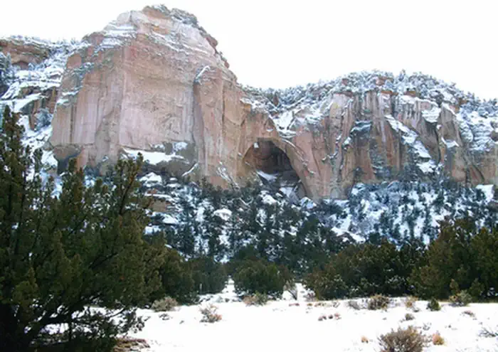
The 61,600-acre Cebolla Wilderness is made up of sandstone mesas, canyons, and grassy valleys. Juniper and piñon dominate, and ponderosa pine is found on north-facing slopes. Vertical escarpments provide excellent nesting habitat for golden eagles, prairie falcons, red-tail hawks, and great horned owls. The Cebolla Wilderness is rich in prehistoric archaeological sites, petroglyphs, and historic homesteads. One notable archaeological site is the Dittert Site. Sometime between A.D. 1000 and 1300, the Dittert Site was built and inhabited by the ancestors of modern Pueblo Indian people. The Cebolla Wilderness also contains La Ventana Natural Arch, a dramatic arch sculpted through wind and water erosion in the sandstone cliffs. The Wilderness is located within the El Malpais National Conservation Area.
The establishment of a Wilderness Area (Wilderness) identifies an area Congress has added to the National Wilderness Preservation System. The BLM manages these areas to ensure their unique wilderness characteristics, primitive recreation opportunities, solitude, and mostly undeveloped areas are protected. Learn more about Wilderness and Wilderness Study Areas.
Photos
Accessibility Description (ABA/ADA)
Cebolla Wilderness has no developed facilities.
Wilderness Study Areas (WSA) are considered for their unique wilderness characteristics, primitive recreation opportunities, solitude, and mostly undeveloped areas.
As a result, this area does not have any facilities or interpretive signage to make the area easier to navigate.
There are no established trails. Existing pathways are overwhelmingly uneven roads, paths, or cow trails. One needs to be able to walk, scramble, and/or cross flowing water while exposed to the elements.
Know Before You Go
Fees
None.
Facilities
There is no drinking water or restrooms in the wilderness area.
Lobo Canyon Trail: a narrow 1.5 mile out and back trail that leads to a series of petroglyphs and gorgeous rock features.
Nearby Amenities
Narrows Picnic Area: 8.5 miles away via NM 117
There are several covered picnic tables, several bearproof trashcans, and two vault toilets.
El Malpais Ranger Station: 20 miles away via NM 117
Operating hours are Friday, Saturday, and Sunday from 8:30 a.m. to 4:30 p.m.
These hours may be more limited going forward due to staff shortages.
This is the nearest location with drinking water. There is a water fountain station in the Ranger Station and an outside spigot near the front door.
The nearest gas stations and stores are located in Grants ~26 miles away via NM-117 W and I-40 W.
Season/Hours
Open year-round.
Road become impassable during inclement weather and after heavy rains.
Special Rules
No motorized vehicles are allowed in the Wilderness.
Please pack out what you pack in and practice a good land ethic.
Pets must be on a 6ft leash. Pets on the lava rock is not recommended.
NO motorized vehicles or mechanical forms of transportation are allowed in the wilderness area.
Dispersed camping is allowed, BUT you must park your vehicle alongside the road and carry your camping gear to your chosen site.
Firewood collection or bringing wood from outside the Wilderness is prohibited.
Brochures, Maps, and Publications
Wildlife in Area
Rattlesnakes
Collared lizards
Coyotes
Elk
Pronghorn
Flickr Album
 >
>Contact Us

Activities


Addresses
Directions
The Cebolla Wilderness is 20 miles south of the El Malpais Ranger Station (BLM) in Grants, NM. Exit the Ranger Station, turn left onto NM – 117 E, and drive for 17 miles. Turn left and travel straight for 3 miles. There will be a small sign marking the start of the wilderness on the right.
Lobo Canyon Trail
From I-40, drive 26 miles south on NM Hwy 117 to Cebolla Canyon Rd. Drive approximately 5 miles (passing Sand Canyon Rd. at approximately 3 miles) to a parking area on the right side of the road. The trailhead is on the north side of the road and leads to a petroglyph area.
Fees
None