
Arizona National Scenic Trail |
The Arizona National Scenic Trail spans over 800 miles from Mexico to Utah. This multi-use non-motorized, long-distance trail highlights Arizona’s topographic, biologic, historic, and cultural diversity. Congress designated it in 2009 as part of the Omnibus Public Lands Bill.
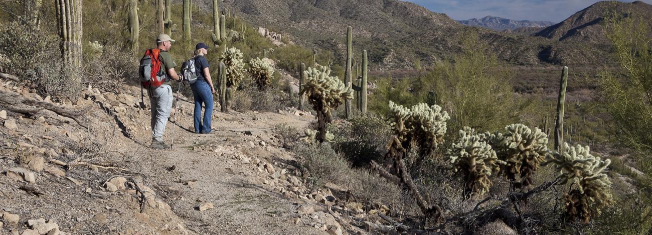
The trail features historic sites, natural landmarks, geologic wonders, and remote wilderness. Opportunities include dispersed camping, hiking, wildlife viewing, photography, mountain biking (outside wilderness, national parks, or other specially managed areas), horseback riding and backpacking.
The BLM manages Passages 15, 16, and 43. These passages are some of the driest on the trail. Whether fall or spring presents better water options depends on the strength of and the balance between winter snowfall and summer monsoons. The Arizona Trail Association has a database of water sources.
The trail does not pass through any designated wilderness on these passages, but it does graze the boundary of the White Canyon Wilderness on the north portion of passage 16. Mountain bikers should be careful not to enter the designated wilderness at this location. Other sections of the trail do pass through parks and designated wilderness where bicycling is prohibited.
Southern Arizona: The Tucson Field Office (TFO) administers 34 miles of trail through two passages, Passage 15 (Tortilla Mountains) and Passage 16 (Gila River Canyons). Passage 15 parallels and then crosses the Tortilla Mountains and Ripsey Wash to reach the Gila River. Passage 16 parallels the Gila River, crosses Walnut Canyon’s outlet, turns north at the trail’s lowest point, and winds through canyons to end at the Tonto National Forest boundary.
Northern Arizona: Passage 43 (Buckskin Mountain) runs through land administered by the Arizona Strip Field Office (ASFO). The northern terminus begins at the Utah/Arizona Stateline Campground in Coyote Valley. The passage here ascends the northern end of the Kaibab Plateau through North Larkum Canyon and offers views of the Vermilion Cliffs National Monument and portions of the east unit of the Baaj Nwaavjo I’tah Kukveni Ancestral Footprints of the Grand Canyon National Monument. The trail then passes through the northern plateau’s pinyon-juniper woodland to reach the Kaibab National Forest’s boundary at the junction with Passage 42 just south of the BLM 1025 road, also known as the Winter Road. The Northbound route starts at the Kaibab National Forest boundary and works north through the pinyon-juniper woodland of the northern Kaibab Plateau and winds around Larkum Canyon offering views of the Baaj Nwaavjo I’tah Kukveni and Vermilion Cliffs national monuments before descending North Larkum Canyon into Coyote Valley. The trail reaches the northern terminus at Stateline Campground.
In wet years, the spring bloom on Passage 43 can be significant among both wildflowers and cacti. Fall temperatures can present good hiking opportunities as well, and adjacent U.S. Forest Service-managed passages to the south have excellent fall foliage. Water sources are extremely limited.
There is no direct road access to the southern end of Passage 43, but 1-2 miles north the trail crosses BLM 1025 road, the Winter Road, which serves as the primary access for the southern end of the passage. The BLM 1025 road is not regularly maintained but is generally accessible by four and all-wheel drive vehicles with good clearance. Summer thunderstorms and winter snow/rain can make access impassable.
Hours and Seasons
Fall and spring provide the best opportunities to hike the trail. Winter is also a good option on the southern passages managed by TFO, but the potential for colder temperatures and heavy snow on the Kaibab Plateau presents challenges at this time of year for Passage 43. Of the passages north of Grand Canyon, Passage 43 is typically the least affected by these conditions, however, so a section or day hike alone may be possible with good timing, planning and preparation.
Features and Services
- Drinking Water: Water sources should be researched in advance, and all natural sources should be filtered before drinking. There is a public water spigot at the Arizona maintenance yard near Kelvin Bridge.
- Toilets: Stateline Campground contains the only developed toilet facilities along any of the BLM passages.
- Cell Phone and Internet: Phone coverage is limited and should be considered unreliable. Due to the remote nature of portions of the trail, users should consider carrying a satellite communicator for use in emergency situations.
- Pets: Pets are permitted along the BLM-managed passages of the trail. Service dogs are legally permitted anywhere that visitors can go. Pack out waste.
Safety and Conditions
You are responsible for your own safety. Call 911 to contact local law enforcement, obtain emergency services, or report a fire.
While enjoying your visit, keep in mind that there is no first aid available on-site.
Respect and Protect
Please remember to practice outdoor ethics and recreate responsibly. Help us protect this unique environment by staying on designated motorized routes, observing wildlife from a distance, and leaving no trace during your visit.
Check for fire restrictions before your visit. Using exploding targets, fireworks, sky lanterns, tracer ammunition and other incendiary devices is prohibited on BLM-managed public land in Arizona.
Accessibility Description (ABA/ADA)
Because the primary purpose of this trail is to provide a primitive experience within an undeveloped natural setting, the site may present challenges to accessibility. Parking, toilet availability and trail conditions will depend on the section of trail you plan to hike.
Please check the Arizona Trail Association webpage and contact the BLM Office that administers the public land each section of trail runs through.
Descriptions and photos uploaded December 2025. Please note that actual on-the-ground conditions may vary due to natural events (e.g., weather, wildfires, erosion), normal wear and tear, or site improvements.
Contact Us

Activities


Directions
Passage 16 North: Tonto National Forest boundary. No direct vehicle access.
Passage 16 South/Passage 15 North: Kelvin Bridge (paved). Accessed via Florence-Kelvin Hwy off AZ-177 from the north or via dirt section of Florence-Kelvin Hwy off AZ-79 from the south. From the town of Superior, take AZ 177 south for 15.2 miles (MP 152.1) and turn south onto Florence-Kelvin Highway (next to RR crossing) for 1.2 miles through the community of Kelvin and cross the Kelvin Bridge. Passage 15 approaches the bridge from below the rock outcrop along the Gila River and ends at the south end of the old bridge. Parking is limited here since the new bridge was completed in 2018. Ample parking is available at the Florence-Kelvin Trailhead ~1.5 miles further west on the Florence-Kelvin Highway. Another option is the BLM trailhead at the end of Centurion Road (one-half mile into Passage 16 northbound). Either location provides easy access to the Arizona Trail.
From Florence, drive 1.5 miles south on AZ 79 and turn left (east) on the dirt Florence-Kelvin Highway. Continue 31 miles to the town of Kelvin and a historic bridge over the Gila River.
From the town of Hayden/Winkleman, drive northwest on AZ 177 about 16 miles then south (left) toward Kelvin. Continue 1.2 miles to the bridge.
Passage 15 South: Freeman Road Trailhead. From Mammoth, drive north on Hwy 77 to the town of Dudleyville. Turn left (west) on Dudleyville Road to the center of the community and locate San Pedro Road. Head west on San Pedro Road, where the road soon turns to dirt. Cross the San Pedro River * (usually dry or very shallow) and then turn north at intersection and follow road north along the river (Camino Rio) for 0.5 mile. Turn left (west) on Freeman Road. Cross railroad tracks and continue for 12 miles to the trailhead.
Passage 43 Northbound: Northern Terminus at Stateline Campground (high clearance in good conditions). The best access is from the north, from US-89, as in wet conditions ruts can form on House Rock Valley Road south of Stateline Campground, and the road is maintained more regularly to the north of the terminus. To access the terminus, turn onto House Rock Valley Rd where US-89 passes through the Cockscomb between Page, AZ and Kanab, UT. From Kanab, drive 38.6 miles east on US-89 and turn right onto House Rock Valley Rd. From Page, drive 35.5 miles west on US-89 and turn left. Once on House Rock Valley Rd, drive 10 miles south, passing the sign for the Arizona/Utah state line, and turn right at the campground sign onto the access road for Stateline Campground. The road crosses a small wash that may present a challenge when wet. The terminus will be immediately on your left when entering the campground.
Passage 43 Southbound: Kaibab National Forest boundary; no direct vehicle access. Indirect access via BLM 1025, Winter Road (high clearance, 4WD or AWD). To access the trail here, turn off US-89A onto House Rock Valley Road 13.7 miles east of Jacob Lake or 33.1 miles west of Lee’s Ferry, and proceed 15 miles north to BLM 1025. Turn left (west) and proceed 3.8 miles to the junction with the Arizona Trail. Watch for a dirt pull-off on the right (north) and a large metal sign in the shape of the state of Arizona that says, “Arizona National Scenic Trail.”
Fees
No fees or permits apply to individual use of the trail. However, commercial, competitive, and large organized group events require a special recreation permit.