
History and Nature
- Monument Management and Collaboration
Located on the Pajarito Plateau in north-central New Mexico, Kasha-Katuwe Tent Rocks National Monument is managed by the Bureau of Land Management (BLM) to protect its important geologic, scenic, and cultural values. The BLM collaborates closely with the Pueblo de Cochiti to enhance public access, manage facilities, ensure resource protection, and promote education and enjoyment of the Monument. The name “Kasha-Katuwe,” meaning “white cliffs” in the Keresan language, reflects the deep cultural significance this area holds for the Pueblo de Cochiti. Designated as a National Monument on January 17, 2001, these lands also serve as an Area of Critical Environmental Concern and feature a National Recreational Trail.
- Geologic Processes and Features
The monument – ranging in elevation from 5,570 to 6,760 feet above sea level – stands as an extraordinary outdoor laboratory where visitors can observe the geological processes that shape our natural landscapes.
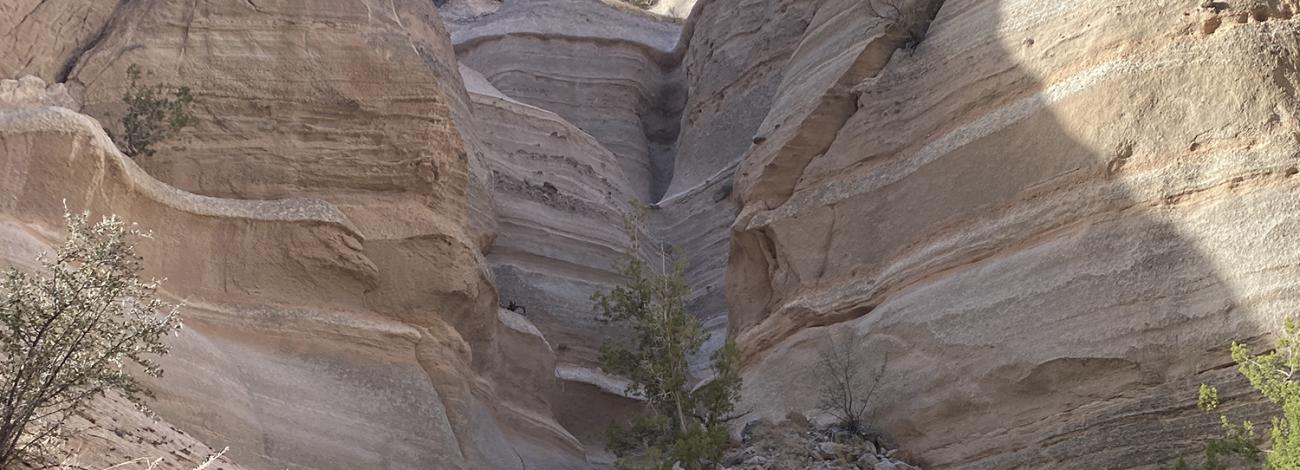
The iconic cone-shaped tent rock formations, often referred to as hoodoos, are the result of volcanic eruptions that occurred 6 to 7 million years ago. Originating from many small calderas within the Jemez volcanic field, the eruptions left behind deposits of pumice, ash, and tuff over 1,000 feet thick. These deposits are visible today as bands of gray interspersed with beige and pink rock along the cliff faces.
At times, particularly explosive eruptions released pyroclasts (rock fragments) while hot gases surged downward in incandescent pyroclastic flows. In the arroyos, close observers may find small, rounded, translucent obsidian (volcanic glass) fragments formed by rapid cooling; please remember to leave these for others to appreciate.
Over time, the forces of wind and water have sculpted the volcanic deposits into the features visible on the landscape today, most notably the hoodoos. Many of these rock towers owe their lofty heights to being capped by resistant layers that protect the softer pumice and tuff layers beneath. Some tent formations, having lost their resilient caprocks, are beginning to erode.
While these formations generally share a uniform shape, they vary significantly in height, ranging from a few feet up to 90 feet. Other local landscape features that owe their shapes to wind and water include canyons and arroyos, rock hollows, and the smooth, semi-circular ends of some ravines.
- History and Cultural Significance
The Monument's complex landscape has drawn visitors for centuries, with archaeological surveys revealing evidence of human occupation stretching back 4,000 years. During the 14th and 15th centuries, several large ancestral pueblos were established, with their descendants, the Pueblo de Cochiti, still residing in the area today. Spanish explorer Francisco Vasquez de Coronado documented the Pueblo de Cochiti in 1540.
Throughout the 17th century, settlers brought trade, farming, and domestic animals to the area along routes established by Spanish conquistador, Juan de Oñate. The Cochiti’s involvement in the Pueblo Revolt of 1680 helped drive Spanish settlers from the region. By 1870, the territory was connected by iron rails, attracting loggers and miners to its rich natural resources.
- Flora and Fauna
The diverse landscape of Kasha-Katuwe Tent Rocks is home to a variety of plant and animal species. Vibrant manzanita shrubs, with their red bark and pinkish-white spring flowers, thrive in the cracks and crevices of the cliffs. Other desert flora includes Indian paintbrush, Apache plume, rabbitbrush, and desert marigold. Depending on the season, visitors may spot various bird species, including red-tailed hawks and golden eagles, soaring overhead. The ponderosa pine and piñon-juniper woodlands provide habitats for larger animals like elk and wild turkeys, while coyotes, chipmunks, and ground squirrels are commonly seen throughout the Monument.