
BLM Closes Kipp, Coal Banks River Recreation Areas for Winter
Organization:
Media Contact:
(FORT BENTON, Mont.) – With autumn’s cold tail of sub-zero temperatures sweeping across central Montana, the Bureau of Land Management has closed the James Kipp and Coal Banks Landing Recreation Areas for the winter season.
Kipp and Coal Banks will reopen around April 1, 2017, depending upon the weather and ice conditions on the Upper Missouri River.
The closures are for public safety. Public safety is a concern at Kipp, because the road down into the recreation area becomes icy and vehicles frequently have difficulty getting back up the hill to the highway. Historically, this has generated a significant number of calls from stranded members of the public.
Due to winter ice and snow conditions, there is little to no recreational use of the campgrounds and boat ramps after hunting season until the arrival of spring.
Coal Banks Landing Recreation Area is in Virgelle, Mont., 12 mi. southwest of Big Sandy. James Kipp Recreation Area is located where U.S. Highway 191 crosses the Missouri River on the Fred Robinson Bridge, approximately 20 miles north of Bohemian Corner in north central Montana
For more information, call the BLM Fort Benton River Management Station (406) 622-4000.
– BLM –
Go to our Flickr page BLMMontana for publication quality images including those used in our news releases.
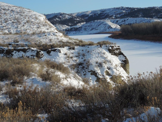
The view from north of the Upper Missouri River looking at the James Kipp Recreation Area, Montana. (BLM photo Jonathan Moor)
The BLM manages about 245 million acres of public land located primarily in 12 western states, including Alaska, on behalf of the American people. The BLM also administers 700 million acres of sub-surface mineral estate throughout the nation. Our mission is to sustain the health, diversity, and productivity of America’s public lands for the use and enjoyment of present and future generations.