
Grand Canyon-Parashant National Monument
Countless biological, historical and archaeological treasures await you in the Grand Canyon–Parashant National Monument.
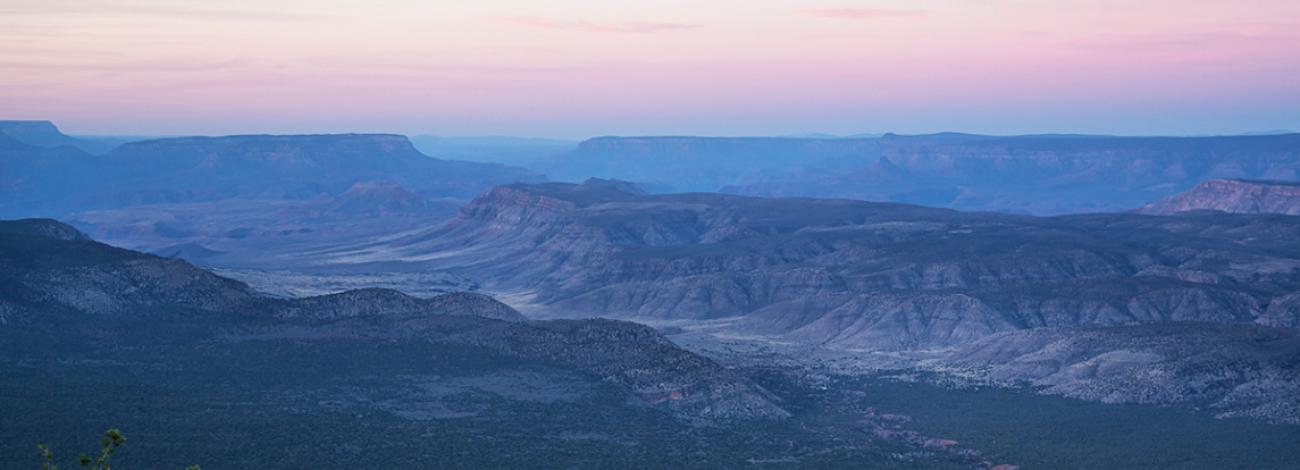
Deep canyons, mountains and lonely buttes testify to the power of geological forces and provide colorful vistas. The monument encompasses the lower portion of the Shivwits Plateau, an important watershed for the Colorado River and the Grand Canyon. Vegetation in the monument ranges from Mojave Desert flora to ponderosa pine forest. Mule deer, bighorn sheep, wild turkey, and four species of rattlesnakes are among the monument’s wildlife.
And when the sun goes down, the night show begins. Grand Canyon-Parashant National Monument has been designated as the Parashant International Night Sky Province for its pristine and breathtaking night skies. That means it is one of the best places in the world to see the stars and planets. Bring a telescope or just open your eyes to see the universe.
Grand Canyon-Parashant National Monument is jointly managed by the Bureau of Land Management (BLM) and the National Park Service (NPS). Covering more than one million acres, Grand Canyon–Parashant National Monument is a scientific treasure. Its deep canyons, mountains, and lonely buttes testify to the power of geological forces and provide colorful vistas. The monument's landscape—relatively underformed and unobscured by vegetation—offers a clear view for understanding the Colorado Plateau’s geologic history. Geologic, geographic, and biological transitions give rise to the monument’s astonishing ecological diversity. Two geologic provinces meet here—the Basin and Range and the Colorado Plateau—along with two ecoregions—the Mojave Desert and Colorado Plateau.
The information found here is not meant to replace a visit to the interagency Public Lands Information Center. Visit the information center to purchase a copy of the Arizona Strip Visitor Map and obtain current, detailed information about road conditions, routes and weather forecasts.
Location
The Grand Canyon–Parashant National Monument is located 30 miles southwest of St. George, Utah.
Directions
It's a challenge to reach and travel through this remote monument. Before attempting to visit the Grand Canyon–Parashant National Monument, get a map at the interagency Public Lands Information Center in St. George, Utah. From St. George, take River Road south to the Arizona/Utah border. BLM Road 1069 will then lead you to several access points.
Visitor Activities
Scenic four-wheel-drive travel, hiking, horseback riding, wildlife and plant viewing, birdwatching, hunting, archaeological and historic sites, and geologic sightseeing are popular activities in the Grand Canyon–Parashant National Monument.
Special Features
For those willing to make the long, remote drive, this monument offers spectacular vistas and scenery. Vegetation ranges from Mojave Desert flora to ponderosa pine forest. A variety of wildlife lives in the monument, including mule deer, bighorn sheep, wild turkey, and four species of rattlesnakes. This is one of the premier areas for mule deer hunting in the country. Permits are extremely limited and regulated through the Arizona Game and Fish Department.
Paleozoic and mesozoic sedimentary rock layers offer a clear view to understanding the geologic history of the Colorado Plateau. The monument encompasses the lower portion of the Shivwits Plateau, an important watershed for the Colorado River and the Grand Canyon. Beyond the phenomenal geological resources, the monument also contains countless biological and historical values.
Permits, Fees, Limitations
General visitor activities don't require any permits or fees.
Accessibility
There are no facilities within the Grand Canyon–Parashant National Monument.
There are several accessible vault toilets available across the monument. Vault toilet facilities are accessible, but do not have hardpacked or paved trails from the parking areas. Restrooms are available at: Mount Trumbull Trailhead, Poverty Mountain, Pakoon Springs, Grand Gulch Mine at Landing Strip, Nampaweap Trailhead, and Tassi Ranch.
Learn more about accessibility at the monument and access large print, braille, and audio-described brochures on the National Park Service's website.
Camping and Lodging
There are no developed campgrounds in the Grand Canyon–Parashant National Monument. The nearest lodging is in St. George, Utah.
Food and Supplies
There are no services on site. The nearest food and supplies are in St. George, Utah.
First Aid
There is no first aid station on site. The nearest hospital is in St. George, Utah.
Your Safety
Before you explore this magnificent and unique national monument, take some time to really plan your visit and make certain you are prepared with the proper equipment, maps and knowledge of the region. You will need to plan for potential hazards such as unmarked rugged roads, venomous animals, extreme heat, and flash floods. Bring plenty of water, food, extra gasoline, and at least two spare tires. We recommend high-clearance vehicles.
Road conditions vary based on weather conditions. Call ahead before coming to the monument. Obtain a map at the interagency Public Lands Information Center in St. George, Utah. Always carry extra water, food, matches or lighter, a signal mirror and foul weather gear. Technology can make backcountry travel more comfortable, but be aware that cell phones, radios and GPS units may not work in many areas. Instead, make sure you have a detailed map to find your way.
Conditions change seasonally and often suddenly. This is a beautiful but unforgiving landscape. You may encounter unexpected snowstorms, flash floods, lightning storms, impassable roads, extreme heat or cold, dried-up water sources and high water from floods or runoff.
Emergency Contacts
- For emergencies: call 911
- Lake Mead National Recreation Area 24-hour emergency dispatch: 1-800-680-5851
- Mohave County Sheriff's Office: 928-753-0753