
BLM New Mexico enhances sustainable recreation at Kasha-Katuwe Tent Rocks National Monument
Listen
Subscribe
Related Content
Kasha-Katuwe Tent Rocks National Monument is a unique geological destination for visitors from around the world. Turning from a hidden gem to a primary tourist destination here in New Mexico, the BLM—in partnership with Cochiti Pueblo—has taken steps to provide a sustainable recreational destination for visitors while also protecting its fragile resources.
Transcript
ELLA KILEY (Public Affairs Specialist): Kasha-Katuwe Tent Rocks National Monument is a unique geological destination for visitors from around the world. Turning from a hidden gem to a primary tourist destination here in New Mexico, the BLM—in partnership with Cochiti Pueblo—has taken steps to provide a sustainable recreational destination for visitors while also protecting its fragile resources. Hello, I'm Ella Kiley, and this is On the Ground, a Bureau of Land Management podcast. This week, I'm here with Jamie Garcia, public affairs specialist with the Albuquerque district office, to talk about Kasha-Katuwe Tent Rocks National Monument and the changes made to improve the visitor experience. Thanks for joining me today, Jamie. Can you tell me about Kasha-Katuwe Tent Rocks and what makes it so unique and special?
JAMIE GARICA (Public Affairs Specialist): Oh, yes, this is one of my favorite areas. I've been working with the monument in a few different roles for the past 18 years. So, I started out in the recreation division and stayed there for about 16 years, working with the monument wilderness areas, wilderness study areas, and other dispersed recreation use, during that time. And, more recently, transitioned into public affairs. So, throughout the years, I have in some way been working with the monument and stuck really closely to that.
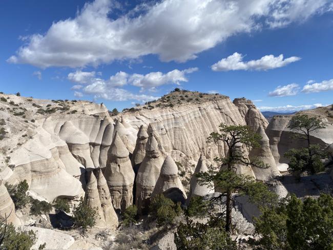
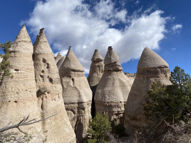
So, the story of the monument actually starts about 6 to 7 million years ago. If you can imagine yourself standing in this valley that we have today with volcanic explosions happening all around you—several volcanic explosions throughout time—they left pumice, ash, and tuff deposits over 1000 feet thick. And during this time, the volcanic field was spewing pyroclasts—which are rock fragments—and also searing hot gases were blasting down the slopes in an incandescent avalanche called a pyroclastic flow.
So, after all of those volcanic events were happening and things started slowing down, wind and water erosion started to happen and started to carve out the canyons that we see today, as well as those beautiful formations. So, if you can imagine you're wearing a rain hat and that rain hat protects your body from getting wet: it's very similar in the fashion that these hoodoos that you see before you have cap rocks—those are the boulders, those very chunky boulders, on the top—and that is like a sort of hat and it protects the column or the body that is underneath. So, when that boulder falls off, the rest of the body will slowly start to erode away. So, that's kind of how these formations were starting to take shape. So, we see anywhere from like a foot-tall hoodoo to a 90-foot-tall hoodoo in some locations here; so, we have very similar shapes, but very different sizes.
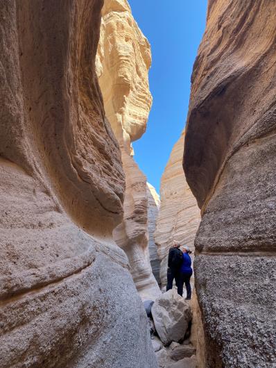
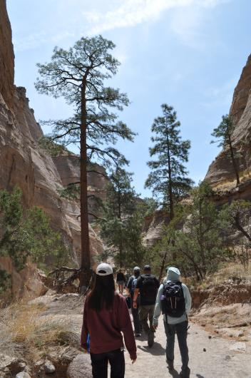
So, when you're at the monument, you can take a few different trails. We have 2 recreational trails—the Slot Canyon Trail and the Cave Loop Trail. And, if you drive a little farther down the road, you can go to the Veterans Memorial Overlook as well, and that has a 1-mile nature loop that you can take. So, all 3 of these trails are really unique. Our most popular is Slot Canyon Trail just because you get to be right in the middle of all of the beautiful twisting, turning canyons and see all the beautiful hoodoos around you.
So, at the trailhead, we're about 5,570 feet above sea level, and by the end of that Slot Canyon Trail in the last quarter mile, you will take a 1,000-foot incline in elevation journey at about 6,760 feet above sea level. So, we always like to tell visitors to come prepared and take your time as you work your way up that part of the trail. Our trails really offer some really great opportunities for hiking, bird watching, geologic observation, and even plant identification, so we really welcome all sorts of exploration here along the trails.
KILEY: So, New Mexico is very culturally rich as well. What is the human history of this area like?
GARCIA: Yes, indigenous people have been inhabiting the Rio Grande Valley for centuries, even through the Pueblo revolt of 1680, where the Pueblo and people fought the Spanish to retain their traditional ways. In particular, Cochiti Pueblo is the gateway community to the monument. And, to this day, they still retain a very close spiritual and traditional tie to this unique location. During planning for the monument, we worked very closely with Cochiti through tribal consultation, collaboration, and just general meetings with each other, to ensure traditional ties and practices remained respected and undisturbed.
KILEY: So, visitors have been very excited about the monument’s reopening. Can you talk briefly about that reopening journey and some helpful steps for visitors as they begin to plan their trips?
GARCIA: Absolutely. We worked really closely with Cochiti Pueblo on a new agreement, and that agreement entrusts Cochiti Pueblo with the day-to-day operations. So, a little bit different than what we had before we closed in 2020 for that extended closure. But we're really excited for what the future holds for this partnership together. So, during this agreement time and how we were discussing what the future of the monument and what we wanted that day-to-day operations to look like, we discussed goals, and we wanted to find a balance between visitor use, resource protection, and respect for Cochiti Pueblo as the gateway community.
So, before our closure in 2020, we were seeing approximately 130,000 visitors at the peak, so it was a lot more than what we had anticipated. Our resource management plan aims to have 50,000 visitors annually, and we really surpassed that. New Mexico became a hotspot for recreational and outdoor tourism around 2007, so we saw a really big increase in visitation during that time. We were starting to see overcrowding on trails: specifically, Slot Canyon Trail is a one-way in and one-way out and has several pinch points in the narrow slot canyon areas, so we are starting to see some concerns for safety in those locations, as well as the visitor experience. You're just jam-packing folks in, and it's just not as enjoyable. We were also seeing long lines of idling cars waiting to get into the monuments, so that was causing a different kind of issue. And then again, back on the trails, we were starting to observe accelerated erosion from all of the foot traffic. So, thinking about you know our visitor experience, the resource protection in the area, and our gateway community—having respect for them—those were some of the big things that were on our mind during this planning process.
So, together, we discussed how we wanted to address that, and we came up with the solution that a reservation system would help alleviate the overcrowding, and Recreation.gov was what we went with. So, Recreation.gov allows us to customize each day and what that looks like. Visitation will have a specific amount of tickets every single day, and we're generally open Thursdays through Mondays. We are closed on Tuesdays and Wednesdays of every week, as well as sporadic days throughout the year for traditional uses for the Pueblo. So, everything that is available is on Recreation.gov. If there are tickets available, fantastic! If they're not available, it's probably one of our closure days that you're noticing.
Additional to that, we also have something a little new: it’s the Cochiti Pueblo Tribal Access Pass, which you will purchase after making your Recreation.gov reservation. And all of these different steps are to help manage traffic and preserve the natural environment, providing environmental education and a more enjoyable visitor experience for all. So, we're really excited to be welcoming our visitors back, and we're looking forward to having you all out here.
KILEY: Fantastic! Thanks for talking to us today, Jamie.
GARCIA: Absolutely! Thank you so much for having me, and we look forward to seeing all of our visitors on trails!