
AIM-ing High in the Chihuahuan Desert
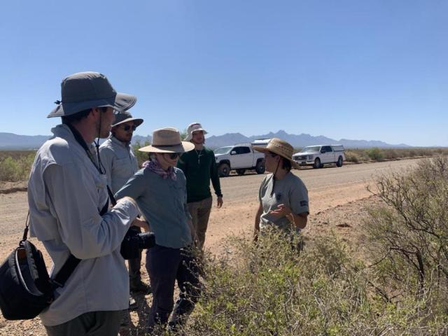
Every summer, in the heat of the desert, field crews gather in Las Cruces, New Mexico to begin a season of ecological landscape monitoring. These field crews congregate to implement the Bureau of Land Management’s Assessment, Inventory, and Monitoring (BLM, AIM) strategy out of the BLM Las Cruces District Office (LCDO). Institute for Applied Ecology Southwest Botanist, Liz Plazewski, currently acts as the Project Lead for the Las Cruces Terrestrial AIM Crews. Liz has completed several seasons of AIM training and mentoring the crews throughout their field season.
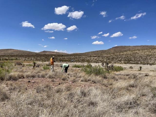
The AIM strategy consists of collecting detailed landscape and vegetation data across various ecological sites on BLM-managed land. Field crews collect their data via a series of standardized methodologies and randomized plot locations. The methodologies include (1) recording vegetation cover and soil surface data through line point intercept, (2) determining ecological site from digging and texturing a soil pit, and (3) notating a complete vascular vegetation composition through species inventory, to name a few. After many levels of quality control and quality assurance, each year’s data is published to be used, summarized, and analyzed. AIM data, since it is collected on public lands, is primarily used by the BLM but is accessible to the public as well. For more information on the AIM strategy and for access to the public data portal, visit blm.gov/aim.
This past 2023 field season, from July through December, LCDO hosted two AIM field crews consisting of two crew members and one crew lead. The crews successfully completed 76 plots distributed across the District in Hidalgo, Grant, Luna, Sierra, Doña Ana, and Otero counties of southern New Mexico.
When asked about her highlight of the field season, crew member Alaine Quinn shared, “All of the cool places we went to. It was fun being out in the middle of nowhere. With our work as an AIM crew, we travelled to such remote areas, and gained a deeper understanding of the landscape.”
Crew Lead Pilar Fuentes felt AIM was important in many ways, especially when it comes to building communal connections, “Oftentimes we are the only people that ranch workers interact with from the BLM, since their ranches are so remote. I feel the work we are doing further strengthens the relationship between stakeholders and the government.”
The crewpersons reflected on their season, “I learned a lot about how to identify plants without flowers—looking at nodes, collars, growth patterns. . . I increased my botany skills, for sure,” said Fuentes. Quinn added, “It was a great field experience. We learned so many different field methods and protocols—many useful skills that are important as I head towards a natural resources career.”
As the 2023 field season wrapped up, the LCDO immediately began to plan and prepare for 2024 season. The District currently has eight seasons of Terrestrial AIM field data collected, a total of 1,035 plots sampled with 171 of those resampled to monitor the change in the landscape over time. Although it is still being planned and mapped out, the 2024 field season is expected to involve more resampling around the month of May. A very special thanks to the Southwest Conservation Corps, who employs the New Mexico AIM crews, and the Las Cruces and New Mexico State BLM for the support for this program.
Related Stories
- BLM Launches a Modernized General Land Office Records System
- Meet Dashiell Gould Lagoyda, fisheries biologist intern at the Safford Field Office
- Celebrating Endangered Species Day: Restoring the Rare MacFarlane’s Four O’Clock
- Growing Resilience from the Ground Up at the Jupiter Inlet Lighthouse ONA
- Volunteer sees cycle of stewardship through her work on historic cave
Office
1800 Marquess Street
Las Cruces, NM 88005-3371
United States