
How to find your way to public lands
Story By: Adam Carr, Public Access Project Manager, Montana/Dakotas State Office
It just got easier to find your way to public lands.
Public Lands Access Geographic Information System (GIS) data is now available for public use.
The data shows easements and patent reservations that provide public access to BLM-managed public lands within Montana and the Dakotas.
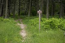
boundary on the Limekiln Trail
near Lewistown. BLM photo
The web app will allow the public to easily identify where access to BLM-managed public lands exists. The GIS data may also be used by other agencies/partners, non-profit groups, and for-profit entities in the development of products they sell related to GPS-enabled mobile navigation and hunting apps.
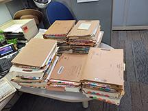
similar to what were researched
to create the Public Lands
Access GIS data.
Photo by Seth Jackson
The Montana/Dakotas Public Lands Access Data was created from researching and creating GIS features from the legal descriptions of easement deeds and patent reservations stored in case files at field offices across the organization. It shows where BLM has perfected access rights that cross privately owned or other agency owned/managed lands to access public lands.
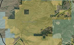
color and a BLM access easement (yellow
line) that exists across a private road.
Please be aware that you are responsible to ensure the roads/trails that you use to get to the access route is a legal public road. Additionally, the access provided does not allow for use of the lands that they cross; only a legal means to access the BLM-managed lands that it leads to.
Development of the data was part of a pilot effort that has now been implemented BLM west wide.
The public can access the MT/Daks Public Lands Access Web App displaying the public access via the BLM Web App Gallery: https://blm-egis.maps.arcgis.com/apps/webappviewer/index.html?id=92ca6ede2e2145419dc116f606bd103c
or the GIS data can be downloaded from the BLM GIS Navigator site:
https://navigator.blm.gov/data?keyword=access&fs_publicRegion=Montana
A Web App user guide is linked within the about text that pops-up when the Web App first opens or can be found here: https://www.blm.gov/sites/blm.gov/files/docs/2021-09/Public_Lands_Access_Web_App_User_Guide_Final_508_0.pdf
Related Stories
- BLM, Partners Enhance Public Access at Popular Recreation Area
- Birding Aravaipa Canyon: A morning of songs, color, and creekside adventure
- BLM Celebrates America’s 250th Anniversary in Oregon
- Framed for Freedom: Bureau of Land Management Eastern States and the Legacy of National Historic Trails
- Reel Partners: BLM and Wyoming Game and Fish Cast a Line for Kemmerer’s Next Generation