


Current Travel Information
Attention monument visitors,
The Grand Staircase-Escalante National Monument Area Road Report is typically updated weekly—more frequently if road conditions warrant. Please ensure:
- Vehicle readiness: Confirm your vehicle is equipped to handle the challenging terrain.
- Stay informed: Keep an eye on weather forecasts and road conditions through reliable resources, including monument visitor centers. Avoid all routes known for frequent flooding or poor maintenance.
Your safety is our priority, but your responsibility. Drive carefully and stay safe!
GSENM Area Road Report
Reference Map
Click the image below to view the companion map, showing the locations of roads referenced in the report below. (Note that this is not a real-time conditions map, and is provided as a reference only.)
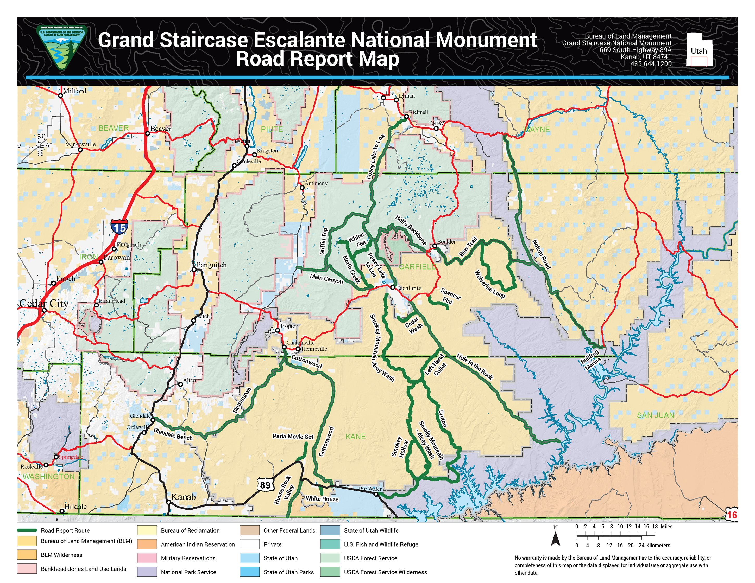
Current conditions: Roads to the east
| Road Name | Date Reported | Road Condition | Notes |
|---|---|---|---|
| Burr Trail | 11/18/2026 | 2WD, Impassable | 2WD for paved section, becomes Impassable on dirt section into Capitol Reef. |
| Notom-Bullfrog | 11/5/2026 | 4WD High Clearance | 4WD High Clearance is needed to Cedar Mesa campground from recent rain. |
| Road to Bullfrog Marina | 11/5/2026 | 4WD, 4WD High Clearance | 4WD High Clearance for crossing. Per Capitol Reef NPS report. |
| Wolverine Loop | 10/28/2026 | Impassable | Damp sections with areas of standing water. Travel not recommended. |
| Cedar Wash | 11/9/2026 | 4WD High Clearance | Road is rough and rutted in places, several mud holes. Travel is not recommended. |
| Hole in the Rock | 11/13/2026 | 4WD High Clearance | Recommend HC-4WD for last 7 miles. |
| Spencer Flat | 10/27/2026 | 2WD High Clearance | 2WD High Clearance! Road damage due to recent flooding! Passable. |
Current conditions: Roads to the north
| Road Name | Date Reported | Road Condition | Notes |
|---|---|---|---|
| Hells Backbone | 11/18/2026 | 4WD High Clearance | 4WD High Clearance is recommended. Unknown Conditions! |
| Posey Lake to Loa | 11/18/2026 | Impassable | Impassable due to snow! |
| Whites Flat (FR #152) | 11/18/2026 | Impassable | Impassable due to snow! |
| Griffin Top | 11/18/2026 | Impassable | Impassable due to snow! |
| North Creek (FR #149) | 11/18/2026 | Impassable | Impassable due to snow! |
| Main Canyon | 11/18/2026 | 4WD/Impassable | 4WD/Impassable. Likely impassable due to snow. |
Current conditions: Roads to the central area
| Road Name | Date Reported | Road Condition | Notes |
|---|---|---|---|
| Smoky Mountain - Alvey Wash | 11/18/2026 | Impassable | The road entrance into Wahweap is accessible to all, but Wahweap is running too fast and deep to cross, |
| Left Hand Collet | 11/7/2026 | Impassable | Impassable due to flooding and rock falls. |
| Croton | 10/31/2026 | Impassable | Deep ruts 1.6 miles south of the Alstrom turnoff make this road impassable from the south. |
| Smoky Hollow | 10/5/2026 | Impassable | A large mud field and many debris flows makes this inaccessible from the south, near its Warm Creek crossing. |
Current conditions: Roads to the west
| Road Name | Date Reported | Road Condition | Notes |
|---|---|---|---|
| Cottonwood | 10/15/2026 | Impassable | Closed by county staff |
| Skutumpah | 11/15/2026 | 4WD | Muddy west of Lick Wash Trailhead. Conditions unknown north of there. Not recommended. |
| Glendale Bench | 11/15/2026 | 2WD | Muddy throughout. Not recommended. |
| Paria Movie Set | 11/18/2026 | Impassable | Muddy across even the flats, and too muddy for travel north of the restroom. Not recommended. |
| House Rock Valley | 11/18/2026 | 2WD High Clearance | Two dozen shallow mud patches lie between HWY 89 and Wire Pass, but careful sedan drivers can get there. Clearance recommended. |
| White House | 11/18/2026 | 2WD | Muddy in spots, but accessible to even sedans. |