Public Access Parcel Nomination Effort
Bureau of Land Management Public Access Parcel Nomination Process 2026
As part of its efforts to implement the John D. Dingell, Jr. Conservation, Management, and Recreation Act, the Bureau of Land Management (BLM) is opening the fourth round of public nominations to identify public land parcels for evaluation under the Act. The Dingell Act directs the Department of the Interior to ask for public input on BLM-managed lands where there is no legal public access or where access is significantly restricted, to improve that access for hunting, fishing, and other recreational activities.
Recommendations from the public will aid the BLM in creating a report to Congress that provides options for reasonably providing access to nominated lands, such as by acquiring an easement, right-of-way, or fee title from a willing seller.
To ensure all stakeholders have ample opportunity and the ability to make suggestions, BLM has created a new web portal to gather public input. The 2026 public nomination period is open for 30 days from July 31 to August 30, 2026. During that time the web portal will be active to solicit public nominations of legally inaccessible or significantly restricted BLM parcels for potential inclusion on the BLM's priority access list.
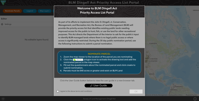
Nomination Portal
Thank you for your DANL 2026 Nomination. BLM is reviewing all of the nominations.
The interactive web map tool provides the public the ability to draw polygons on a map representing the public land areas they believe lack access or have significantly restricted access. Polygons for all nominations will be visible, including those parcels added to the BLM Priority Access List, parcels still under agency consideration, and parcels eliminated from consideration. This map tool will help inform the public of the status and location of all previously submitted priority access nominations. The public will be asked to provide a limited amount of information about the new parcels they nominate.
Nomination Requirements
Valid nominations must include the location of the nominated land or parcel, total acreage affected (if known), a description or narrative describing the lack of access, and any additional information the BLM should consider when determining if the land should be on BLM’s priority access list. The BLM will not include any personal identifying information concerning owners or ownership of any parcels in preparing the priority list or related congressional reports.
This effort advances a primary goal of the Dingell Act (S. 47), which was signed into law in March 2019. Section 4105 of the Act directs the BLM to develop a priority access list.
Implementing the Dingell Act will continue the BLM’s mission to support multiple uses for public land, and to strike a balance for land and resources management, increase access for hunting, fishing, and recreation, and create economic prosperity while protecting and preserving America’s treasures.
- Background
All lands nominated for inclusion on the BLM’s priority access list must be managed by the BLM, encompass at least 640 contiguous acres and have significantly restricted or have no public access. BLM must also consider the likelihood of resolving identified access issues when determining whether to include parcels on the list. When submitting nominations, the public must include the location of the nominated land or parcel, total acreage affected (if known), a description or narrative describing the lack of access, and any additional information the BLM should consider when determining if the land should be on BLM’s priority list. BLM will not include any personally identifiable information concerning owners or ownership of any parcels in preparing the priority list or related congressional reports.
The BLM is working to implement Dingell Act tasks assigned in Alaska, Arizona, California, Idaho, Utah, Montana/Dakotas, Nevada, New Mexico, Oregon/Washington, and the Eastern States Office (Louisiana, Virginia, and Minnesota). Implementing the Dingell Act will continue the Department of the Interior’s work to strike proper balance for land and resources management, increase access for hunting, fishing, and recreation, and create economic prosperity while protecting and preserving America’s treasures.
Learn more about the Dingell Act and how it affects your public lands.
- The Dingell Act Priority Access List
The BLM sought public nominations for a 30-day period, which ran from August 1 to August 30, 2024, to encourage participation in identifying high-priority recreation lands at least 640 contiguous acres, where legal public access is either non-existent (legally inaccessible) or significantly restricted (press release). Nominated lands must be open for recreation consistent with existing land use plans.
The public’s response was robust, demonstrating a significant level of interest and high importance that the public, state agencies, and non-governmental partners assign to the issue of improving recreational access to public lands across the West. A total of 114 new nominations were received in 2024 from 9 recreation user groups, 8 conservation organizations, 42 BLM offices, 7 other federal agencies, 13 state, county, and local governments, and 35 individuals. Many individuals self-identified as hunters, outdoor recreationists, and/or public land advocates.
The BLM’s final priority access list includes a total of 1,016 distinct parcels spread across 14 western states (AZ, CA, CO, ID, MT, ND, NM, NV, OR, SD, TX, UT, WA, and WY). These parcels represent approximately 5.79 million acres of legally inaccessible or significantly restricted public lands with exceptional recreational values. From the total 7,019 total nominations received in 2020, 2022, and 2024, 1,016 distinct parcels of BLM-managed public lands are included on the priority access list and 90 nominations continue to be evaluated by the BLM. The BLM successfully removed 7 nominations on prior lists in Arizona (3), Idaho (2) and Oregon (2) as the restricted or no public access has now been resolved. The BLM also eliminated 5,906 nominations from consideration because they were duplicate submissions, did not contain sufficient information, or did not meet the Act’s criteria.
More information on the Dingell Act Priority Access Parcel list
- Summary Table of BLM Priority Access List and Acreages by BLM State Office
State Office
Total # Parcels on Priority Access List
# BLM Nominated Parcels
# Public Nominated Parcels
# Legally Inaccessible Acres
# Significantly Restricted Acres
AZ
74
39
35
78,856
418,266
CA
20
12
8
12,039
107,235
CO
136
124
12
92,951
551,737
ID
175
80
93
462,979
444,335
MT/DK
173
80
93
462,979
372,328
NM
35
21
14
72,608
118,313
NV
41
37
4
1,029,855
247,041
OR/WA
145
79
66
157,670
352,333
UT
17
15
2
71,375
10,983
WY
200
53
147
393,971
412,057
Totals
1,016
605
411
2,759,876
3,034,628