
Pueblo La Plata Cultural Site | Arizona
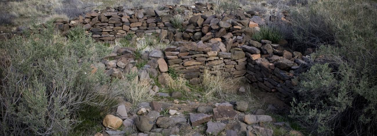
Pueblo la Plata is a prominent archaeological site in the Agua Fria National Monument. It was once a large village with 80–90 rooms set atop a mesa surrounded by desert grasslands and steep canyon walls. Visitors can walk among low-standing wall remnants and enjoy ridge-top views of the canyon and Silver Creek below.
Occupied between AD 1200 and 1450 by approximately 3,000 people, Pueblo la Plata showcases stone-walled architecture, agricultural terraces, and signs of long-distance trade with Puebloan communities and the Verde River Valley. The site reveals a complex society that managed water and land resources and used fortifications to monitor the surrounding landscape.
Hours and Seasons
Open year-round, 24 hours a day.
Features and Services
- Access and Parking: There is a gravel parking lot near a fence surrounding the area. Walk through the gate and follow a flat, 0.25-mile trail to the cultural site.
- Cell Service: Limited; expect poor reception.
- Toilets: None.
- Drinking Water: None.
- Pets: Allowed on leash; please pick up after your pet.
- Camping: Primitive, dispersed camping is permitted on nearby BLM lands; check local regulations for fire and camping guidelines.
- Nearby Amenities: Nearest services are in Black Canyon City and Cordes Lakes: food, fuel, lodging, and medical care.
Respect and Protect
Historic and archaeological sites are protected by law. Please leave artifacts where you find them and do not climb on walls or structures. By practicing responsible outdoor ethics, you help ensure future visitors can enjoy this remarkable site.
Accessibility Description (ABA/ADA)
The trail to Pueblo la Plata follows rocky and uneven natural terrain. It would not generally be considered wheelchair accessible.
Contact Us

Activities


Geographic Coordinates
Directions
From Interstate 17 (north of Phoenix), take Bloody Basin Road exit (Exit 259). Drive 8.3 miles on Bloody Basin Road, then turn north onto a dirt road and drive about one mile to the Pueblo la Plata parking area. You can identify this road by the earthen cow tanks a short distance down it. A high-clearance vehicle is recommended beyond the first paved 5 miles of Bloody Basin Road.
Fees
The Pueblo La Plata Cultural Site is free (no fee required) for general visits by the public.
However, commercial, competitive, and large organized group events require a special recreation permit. Contact the Hassayampa Field Office for more information about special recreation permits.