
Cosumnes River |
Remember your OUTDOOR ETHICS when enjoying your public lands. Please RECREATE RESPONSIBLY.
Explore, learn, and experience the Cosumnes River Preserve with opportunities for guided walks, paddling, hiking, and nature viewing. The Visitor Center deck and outdoor exhibits are open to the public even when the indoor exhibit room is closed.
Please Note: No pets. Only service dogs, on the leash, are allowed at the Preserve.
No camping at the Preserve. Day-Use area only.
For up-to-date info & more, please visit Cosumnes River Preserve homepage at: www.cosumnes.org
Overview
The Cosumnes River Preserve is home to California's largest remaining valley oak riparian forest, and is one of the few protected wetland habitat areas in the state. The Preserve includes over 50,000 acres of central valley grasslands, vernal pools, wetlands, and valley oak forests.
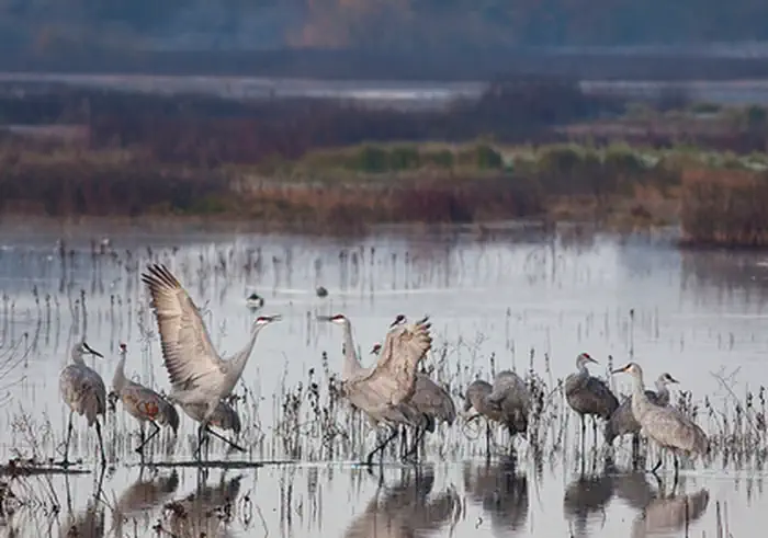
Nestled in the heart of California's Central Valley, the Preserve is a critical stop on the Pacific Flyway for migrating and wintering waterfowl. Over 250 species of birds have been sighted on or near the Preserve, including the State-listed threatened Swainson hawk, greater and lesser sandhill cranes, Canada geese, and numerous ducks. The Cosumnes is the last free-flowing river from the mighty Sierra Nevada Mountains into the Great Central Valley.
Hunting and Shooting Info - Cosumnes River Preserve:
Hunting, fishing, and camping are not allowed at the Cosumnes River Preserve. In general, there is no hunting allowed in the core area of the Preserve because it is not compatible with our public use and wildlife protection objectives.
Hunting and fishing are allowed on the river and in the sloughs, but hunters and fishers must stay in their boats (no bank fishing/hunting). It is legal to fish or hunt from a boat in the river, in a state navigable waterway, but only during the proper seasons and with the proper licenses.
- Special scheduled hunts available by permit.
- Youth and mobility-impaired hunters contact CRP @ (916) 684-2816
- BLM Lands within the Cosumnes River Preserve ACEC boundary are CLOSED to hunting and target shooting.
NOTE: All California game species are regulated by the California Department of Fish and Wildlife (CDFW). Rules, regulations, and seasons are controlled by CDFW, and it is the hunter's responsibility to verify and comply with proper species, seasons, zones, regulations, and legal location if hunting on public lands.
FGC 3004 — It is unlawful for any person to hunt or discharge while hunting, any firearm or other deadly weapon within 150 yards of any occupied dwelling house, residence, or other building or any barn or other outbuilding used in connection therewith. The 150-yard area is a "Safety Zone."
Helpful Links:
- Where to Shoot
- California Department of Fish & Wildlife
- Hunting, Fishing and Recreational Shooting on Public Lands, BLM California
More Helpful Links:
- Visit CRP Homepage: Cosumnes River Preserve
- Explore the Trails at the Preserve: River & Wetlands Trails
- Also visit BLM at: Cosumnes River Preserve Visitor Center
- Return To: BLM, Mother Lode Field Office
Photos
Accessibility Description (ABA/ADA)
View images of accessibility features in a new window.
Parking. There are 3 paved parking lots for the Preserve, all just off Franklin Blvd. The upper lot holds about 40 vehicles and has 2 designated accessible spaces with access aisles. Next to it, to the east, the lower lot holds about 20 vehicles and has no designated accessible spaces. The lot near the entrance to the Boardwalk Trail, ¼ mile to the north, has 6 spaces, 1 of which is designated as accessible. Cell reception is good nearly everywhere in the site. No drinking water is available.
Kiosks. A kiosk with a trail map, rules, and site interpretation sits on concrete near 2 wood benches and a double-vault toilet at the upper lot. A 3-sided kiosk next to the Boardwalk Trail parking lot also sits on concrete and has the same information.
Toilets. An accessible double vault toilet is next to the accessible parking in the upper lot. There is also an accessible single vault toilet next to the accessible space in the Boardwalk Trail parking lot.
Trails. The Preserve has 3 trails. The Boardwalk Trail is an accessible 1/4-mile out-and-back trail (½ mile total). It starts at the Boardwalk parking lot as a concrete path, becomes a raised boardwalk with a wood bumper, and ends at a wooden observation deck with railings and 4 benches without arms or backs. The observation deck overlooks a pond.
The Wetlands Walk is an accessible 1-mile loop, consisting of concrete pathways, wooden bridges, and boardwalks over slough and wetland areas. It crosses Franklin Blvd at the north and south ends of the loop. There are small observation decks and 6 benches, most without arms or backs, along this trail. The Wetlands Walk can be accessed from the upper parking lot and the Boardwalk parking lot.
The River Walk Trail begins near the Visitor Center. It is accessible only with all-terrain wheelchairs in dry weather. When it rains, this flat, compacted dirt trail gets quite muddy. This 3-mile loop trail leads to 3 wetland areas and the Cosumnes River and loops back through oak savannah woodland. There are 3 benches without arms along this trail.
The trails have numbered posts with QR codes that can be scanned to obtain information about features of the site. A digital trail guide including 3 guided-hike videos, guided trail map for kids, and a printable trail map are available at https://www.cosumnes.org/hiking-trails/
Boat Dock. A concrete sidewalk leads from the upper parking lot to a boat ramp and boat dock, southwest of the Visitor Center. Benches are along the path and an informational sign is near the ramp. The river level can vary by up to 12 feet. At high tide, the boat ramp has a gentle enough slope to be considered accessible. At low tide, the ramp is very steep.
Note: Descriptions and photos uploaded April 2025. Please note that actual on-the-ground conditions may vary due to natural events (e.g., weather, wildfires, erosion), normal wear and tear, or site improvements.
Contact Us

Activities


Directions
From Sacramento, take Interstate 5 south and exit at Twin Cities Road. Head east on Twin Cities Road to Franklin Boulevard, then turn south. Continue on Franklin Blvd and go past Desmond Road. The Cosumnes River Preserve Visitor Center is approximately 1/2 mile south along Franklin Blvd on the left (east) side.