
The Bureau of Land Management closes recreation sites in northwestern Oregon due to fire risk
Organization:
BLM Office:
Media Contact:
PORTLAND, Ore. – As a result of extreme fire activity, the Bureau of Land Management Northwest Oregon District has temporarily closed all recreation sites and certain roads from September 8 through September 15.
All BLM developed campgrounds in northwestern Oregon are closed to the public, and dispersed camping is prohibited. Members of the public may not enter closed recreation areas. This temporary closure covers the northwestern part of the state, west of the Cascade Range and north from Cottage Grove to the Columbia River, and includes popular spots, such as Fishermen’s Bend campground, Wildwood recreation site, Alsea Falls recreation site, Shotgun Creek day use area, and the Row River Trail.
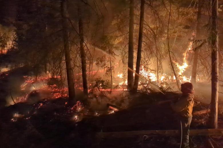
Public and firefighter safety are the highest priority. Extreme fire activity, fueled by a rare fire weather event with low humidity and strong east winds of 15 to 30 mph and gusts up to 50 mph, occurred on several fires located in northwestern Oregon on September 7 and 8. The extreme fire danger and behavior have prompted the closure of these sites while fire suppression crews respond to the incidents. As it becomes safe to do so, firefighters will begin to assess the fires and their impacts in alignment with sound risk management practices.
Multiple new fires started on Bureau of Land Management, U.S. Forest Service, and private lands in the region have prompted Level 3 “Go” evacuations. Moderate to heavy smoke impacts from the fires are expected to continue along the western slopes of the Cascades and into the Willamette Valley.
Personal safety is paramount. Stay informed on air quality ratings and more by visiting the Oregon Smoke Blog at http://oregonsmoke.blogspot.com/. Learn how to stay safe from wildfire smoke at https://www.cdc.gov/wildfires/about/index.html.
A Red Flag Warning for the persistence of critical fire weather on the heels of this historic September event will remain in effect until 8pm Wednesday. Conditions during this time will remain favorable for continued rapid fire spread.
Nearby residents and visitors to the area are encouraged to check with local emergency officials for the latest information on evacuations.
- Marion County https://www.facebook.com/MCSOInTheKnow
- Lane County https://www.facebook.com/LaneCountyGovernment
For the latest road and weather condition updates, visit https://www.tripcheck.com/.
Additional fire information is available on Inciweb:
- Beachie Creek
- Lionshead Fire
Please call 911 to report any signs of new fires.
Please observe public use restrictions and help us limit potential new starts during this time. A list of personal use restrictions, as well as closure orders, are available at https://www.blm.gov/programs/public-safety-and-fire/fire-and-aviation/regional-info/oregon-washington/fire-restrictions. You can also follow us on Facebook and Twitter @BLMOregon. For a map of the Northwest Oregon District, visit https://www.blm.gov/office/northwest-oregon-district-office.
The BLM manages about 245 million acres of public land located primarily in 12 western states, including Alaska, on behalf of the American people. The BLM also administers 700 million acres of sub-surface mineral estate throughout the nation. Our mission is to sustain the health, diversity, and productivity of America’s public lands for the use and enjoyment of present and future generations.