Poison Spider Mesa Trailhead | Utah
Poison Spider Mesa Trailhead provides access to some of Moab’s most iconic recreation, including the 16-mile Poison Spider Mesa 4×4 and mountain bike loop, the Golden Spike Route, and hiking trails such as Longbow Arch (1.1 miles one way) and Poison Spider Bench (1.3 miles one way). A short side trail leads to petroglyphs and a dinosaur tracksite where footprints from at least 10 carnivorous dinosaurs can be seen. This mix of off-road adventure, family-friendly hikes, and cultural and paleontological discovery is set against sweeping views of the Moab Valley, Colorado River, and La Sal Mountains.
The Poison Spider Mesa dinosaur tracksite features theropod footprints — identified as Eubrontes and Grallator — preserved in limestone blocks that fell from the overlying Jurassic Navajo Sandstone. These tracks formed about 190 million years ago in fossilized pond deposits between giant sand dunes, offering rare insight into dinosaur behavior and movement. Nearby petroglyphs, carved by ancestral Indigenous peoples, depict human and animal figures and provide a fascinating glimpse into the cultural history of the region. Interpretive signage by the BLM explains the site’s significance and encourages visitors to respect and protect these fragile remnants from the past.
Hours and Seasons
Open year-round. Summer temperatures can be extreme and shade is limited; morning or evening visits are recommended.
Features and Services
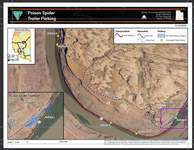
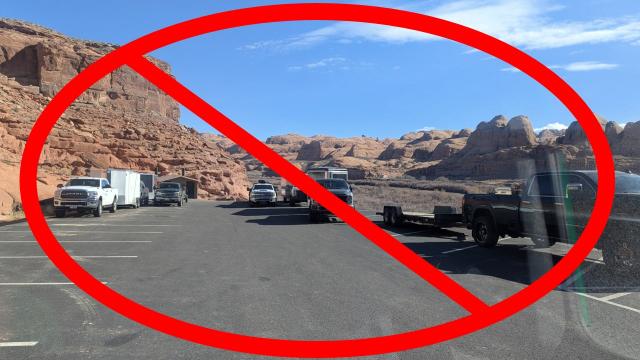
- Access and Parking: The Poison Spider Mesa Trailhead parking area is designed for vehicles that fit in a single standard space. Please note that multiple user groups begin their adventures here, so space is limited. Trailer parking and staging are not allowed in or along the entrance road or lot, as this creates safety hazards and blocks access for others. For trailers, use designated pullouts along Potash Road before and after the trailhead, ensuring your vehicle and trailer are completely off the highway and outside the white line. Additional overflow parking is available at the Gold Bar Recreation Site.
- Cell Service: Limited and inconsistent; do not rely on mobile coverage.
- Toilets: None available on-site.
- Drinking Water: None available on-site; please bring your own.
- Pets: Pets are allowed on leash.
- Camping: Overnight camping is prohibited at the trailhead. Visit Moab Information Center for nearby public and private camping options.
- Nearby Attractions and Amenities: Moab (6 miles east) offers food, fuel, lodging, medical services. Recreational opportunities abound — visit the Moab Information Center webpage and facility for details.
Respect and Protect
Within the Moab area, all vehicles and bikes must stay on marked, designated routes. Please do your part to preserve the natural beauty of the area. Visit treadlightly.org to learn more.
Dinosaur tracks and bones are amazing to experience. You may look and gently touch but remember, these fossils are very fragile and irreplaceable, so avoid walking on, scraping, or marking them. Do not touch any petroglyphs, as the oils from human hands over time causes damage to these culturally significant inscriptions. By practicing responsible outdoor ethics, you help ensure future visitors can enjoy this remarkable site.
Photos
Accessibility Description (ABA/ADA)
The terrain includes uneven, rocky surfaces and sandy areas; this trailhead and its short walks are not wheelchair accessible.
Contact Us
Activities
Addresses
Geographic Coordinates
Directions
From Moab, drive west on Potash Road (State Route‑279) for about 6 miles. Turn right at the “Dinosaur Tracks” sign and continue uphill to the Poison Spider Mesa Trailhead parking area.
Fees
No fees are required to visit the Poison Spider Mesa Trailhead.


