
Recreation at Red Rock Canyon NCA
- Scenic Drive
Timed entry reservations are required for the Scenic Drive between October 1-May 31 for entry between 8 a.m.-5 p.m. Timed entry reservations can be made online by visiting Red Rock Canyon Scenic Drive Timed Entry - Recreation.gov or by calling 877-444-6777.
The Red Rock Canyon Scenic Loop Drive doubles as a backcountry byway. It is a 13-mile (21 km), paved, one-way scenic drive that passes through arid desert landscapes, red and buff colored rock formations, beautiful sandstone and limestone cliffs that reach elevations of over 7,000 feet (2100 m).
The Scenic Loop Drive is beautiful for visitors in motorized vehicles and also popular for bicyclists. All traffic is required to travel one-way. Many pull-outs provide parking, so you can explore the desert on one of the many trails Red Rock Canyon National Conservation Area has to offer. You may also see visitors getting ready to hike into the backcountry, to go horseback riding, or to rock climb. Watching climbers has enthused and entertained many visitors over the years.
The Scenic Drive opens at 6:00 a.m. every day of the year unless Mother Nature provides a flash flood from seasonal rainstorms or the occasional snowstorm. The Scenic Loop Drive closes around sunset – 5 p.m. November through February; 7 p.m. March and October and 8 p.m. April through September 30.
Follow posted speed limits, so you can be safe and protect visitors and wildlife. If parking lots are full, please do not create your own parking spot by driving off the road and onto vegetation. These plants are native to the arid Mojave Desert of Red Rock Canyon and can take decades to regrow. Please continue to a new parking area or enjoy the drive in its entirety and enter later in the day as your fee receipts are good for the entire day (with a valid reservation when applicable).
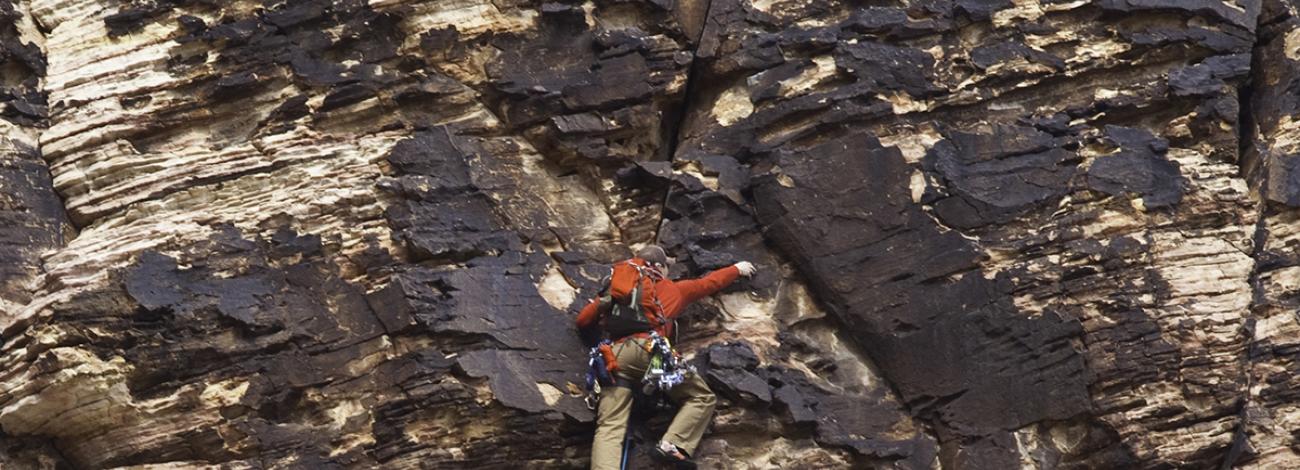
- Rock Climbing
Red Rock Canyon National Conservation Area is one of the finest rock climbing areas in the world.
If you have never climbed at Red Rock Canyon and are unfamiliar with route locations, three guide books with extensive route information available in local climbing shops. Websites and apps like Mountain Project may also provide great suggestions, but please keep in mind these are community moderated and updated (results may vary, and information here is not endorsed by Red Rock Canyon National Conservation Area or the Bureau of Land Management). For detailed information, please refer to any of the three guide books for Red Rock Canyon:
- Rock Climbing Red Rocks by Todd Swain
- The Red Rocks of Southern Nevada by Joanne Urioste
- A Climbers Guide To The Red Rocks of Nevada by Randy Faulk
If you would like to contact any of the climbing staff at Red Rock Canyon, please call 702-515-5358.
Timed entry reservations are required for the Scenic Drive between October 1-May 31 for entry between 8 a.m.-5 p.m. Timed entry reservations can be made online by visiting Red Rock Canyon Scenic Drive Timed Entry - Recreation.gov or by calling 877-444-6777.
Rules and Regulations
The Red Rock Canyon Scenic Drive is a day use area only. Late exit permits are available online at Red Rock Canyon Backcountry Late Exit Pass - Recreation.gov. People can request a permit by clicking the "Buy a Pass" button on the website. Late exit permits are free, but a 50-cent processing fee will be charged.
- The late exit permit allows you to be in the Scenic Loop Drive area after closure for long or over-night routes.
- Camping is permitted at the developed campground two miles east of the visitor center on (W. Charleston Blvd) State Route 159. Camping is not permitted on or from the Scenic Loop Drive.
- If you want to sport climb and the parking lot of the area you choose is full, go to the next parking lot and hike back to the desired location, or choose another area.
- Respect other climbing parties! Some of the more popular long routes get crowded.
- Allow for space between parties above and below you on the wall.
- Allow faster parties to climb through.
Rock Type
The main type of rock found in Red Rock Canyon here is Aztec Sandstone, formed years ago through the natural cementing of ancient sand dunes. The rock at Calico's 1& 2, and Sandstone Quarry are the focus of sport climbing. The rock of the main escarpment possesses a greater cementing factor and is considered to be a good quality sandstone. The black or varnished rock is generally considered to be the hardest. Keep in mind however, it is still sandstone. Because of its friable (crumbly) nature it must be approached with a greater degree of caution than a more dependable rock such as granite. We suggest waiting 24 to 48 hours after major rains or snow to allow the rock to dry sufficiently for climbing.
Ratings
Routes in Red Rock Canyon are rated via the Yosemite Decimal System. All class V routes (those involving the use of protection) in Red Rock Canyon range from 5.0 (easiest) to 5.14 (most difficult.) These ratings are based on the skills, abilities and opinions of those climbers that have ascended each specific route. If you are not familiar with this rating system or are unsure of what level you and your abilities fit in, be sure to choose your first ascents in Red Rock Canyon with care. Red Rock Canyon offers hundreds of established sport and traditional climbs, from grade I (1-2 hours) to grade VI (spending 2 or more nights on the route).
Access
Many routes in Red Rock Canyon require significant walking, hiking and scrambling to reach them. Keep this in mind when planning for your climbs, not only as a time constraint but also in terms of water. Red Rock Canyon is located in the Mojave Desert, and even if it is not scorching hot, the air is still very dry. You should always bring a surplus of water to stay hydrated.
The Late Exit Pass pass allows you to leave after hours or overnight parking along the scenic drive when climbing a long or multi-day route. If you leave your vehicle parked along the scenic drive without a permit, your vehicle will be cited and possibly towed at the owners expense.
Important Safety Tips
- This is the desert; winter can be very cold and snow is not uncommon in the winter months, In the summer months temperatures can reach an excess of 110 ° F (43 ° C). Summer storms can cause very cold conditions on long backcountry routes, and canyons can flash flood, without warning.
- There are poisonous animals in Red Rock Canyon. Rattlesnakes, black widows, bees, wasps, and velvet ants are all creatures to keep a distance from.
- Sandstone is naturally porous and friable rock. It is a local request that routes are given 24 hours to properly dry. This helps to protect existing routes from key hold breakage.
- Bolting along the main escarpment, which is a wilderness area, is illegal and should not be done. Bolting is legal along Calico 1 & 2 but should be done only after consulting the climbing staff, a local climbing shop, or the Las Vegas Climber's Liason Council.
- Lock your vehicle while climbing and do not leave tempting or valuable items in plain view. Do not leave your wallet in the car at all, even hidden.
Respect Public Lands
Respect the natural and cultural resources of this beautiful land, leave all natural features just as you found them.
- Don't litter, pack out what ever you pack in. Practice, "leave no trace ethics" and do not leave your toilet paper or cigarette butts behind.
- Don't build any ground fires, or cover your own stove, cook only with a barbecue grill.
- Respect the rights of other visitors to enjoy Red Rock Canyon.
- Climbing is prohibited on or within fifty (50) feet of cultural sites.
Bivouac (Bivy) Permits
You may get an overnight bivy permit for routes on Mt. Wilson, Levitation Wall, Rainbow Wall, Bridge Mountain, Hidden Wall and the Buffalo Wall. The bivy permit does not allow you to camp in the canyons, but it does allow to you stay on the wall. The following is a list of all areas that will be available for one-night or two-night bivy permits. These permits are for on route, or summit bivies only. Permits are available online by visiting Red Rock Canyon Backcountry Late Exit Pass in Nevada - Recreation.gov. People can request a permit by clicking the "Buy a Pass" button on the website and picking the parking lot where you are parked and the route you are climbing. Permits are free, but a 50-cent processing fee will be charged.
- Mount Wilson: All routes on Mt. Wilson are available for a one-night permit.
- Levitation Wall: All routes on Levitation Wall are available for a one-night permit.
- Rainbow Wall: All routes on Rainbow Wall are available for a one or two night(s) permit.
- Buffalo Wall: All routes on Buffalo Wall are available for a one, two, or three night(s) permit.
- Bridge Mountain: All routes on Bridge Mountain are available for a one-night permit.
- Hidden Wall: All routes on Hidden Wall are available for a one-night permit.
- Hiking Trails
Please stay on established trails in Red Rock Canyon National Conservation Area. Cutting across switchbacks damages soils and plants, contributes to erosion, and severely damages the trail. Thin black crusts of moss, bacteria, lichen -- called biological soil crust or cryptobiotic soil crust -- cover open areas and protect desert soils from wind and rain erosion. Any foot traffic quickly destroys these crusts, which are slow to regrow. Biological soil crust can take up to 50 years to recover in the Mojave Desert, and even then only if left fully undisturbed. If is it necessary to hike off trail, please follow rock outcroppings, washes, or areas of sand and gravel that are free of vegetation and biological soil crust.
Each year people are lost, injured, or killed while visiting Red Rock Canyon National Conservation Area. For your safety, please follow these simple rules:
- When hiking, stay on established trails and watch your footing at all times. Steep slopes and cliff edges are dangerous.
- Do not roll or throw rocks and other items from high places; other visitors may be below you.
- Watch for snakes on the rocks.
- Temperatures can exceed 110° F (41° C) in Red Rock Canyon. Drink four liters of water per day in the summer, and make sure to bring it with you or to fill up at the Red Rock Canyon Visitor Center. No water is available at any other trailheads or in the backcountry.
- Avoid drainages after thunderstorms or severe weather because of flash floods. Stay away from high points during thunderstorms; lightning can kill.
- Wildlife may appear to be tame but may attack if threatened. Stay a safe distance away while observing animals.
- Watch children closely; they often do not recognize potential dangers.
- The burros at Red Rock Canyon are not domesticated animals and can be dangerous. Do not feed or pet the burros. Feeding burros encourages these animals to congregate on roadways where many have been killed and injured by vehicles. To observe these animals safely: pick a safe place to stop; pull completely off the roadway, observe the burros from a distance. Staying in your car is the safest way to photograph and observe the burros.
- To protect resources, please do not collect plants, rock specimens, fossils, or disturb the wildlife.
- Let someone know where you will be hiking. There is a voluntary hiker's registration at the visitor center.
- Dress appropriately; wear footwear suitable for hiking and consider wearing a hat.
- Be aware of the weather. Mountain thunderstorms can cause flash flooding in the canyons and nearby washes.
- Please, if you pack it in, pack it out and dispose of properly.
- Be aware of the closure hours for the scenic drive.
The following is a brief list of the more popular hikes in the area. It is best to carry a map of the area. Maps of the Red Rock Canyon are available for sale at the bookstore in the visitor center.
Hiking Trails in the Scenic Drive Vicinity
Georeferenced PDF maps are available for most of the below hiking trails.
1. MOENKOPI LOOP: (2.1 mi/3.4 km, easy) Triassic fossils and various desert flora can be seen on this open country trail which starts at the visitor center just west of the weather monitoring station and traverses a prominent limestone ridge. In addition to panoramic views of the Wilson Cliffs, there are connecting trails to the Calico Hills area.
2. CALICO HILLS: (distance variable, easy to moderate) This trail runs along the base of the Calico Rocks from Calico Basin to Sandstone Quarry. Distance is variable since the trail can be accessed at either end or from either of the two Calico parking areas. A side trail runs from the fee booth parking lot and connects with this trail.
3. CALICO TANKS: (2.5 mi/4.0 km round trip, moderately strenuous) From Sandstone Quarry the trail heads north from its junction with the Turtlehead Peak Trail to just past the Agave roasting pit site. Just beyond this site, the trail veers up a side canyon to the right where it follows ascending rock terraces to a large natural water tank (tinaja). Water may be present in the tanks after seasonal rains. Rock scrambling and route-finding skills recommended.
4. TURTLEHEAD PEAK: From Sandstone Quarry the trail heads north over a narrow rise, in and out of a wash, then continues for a short distance along the northwest side of Turtlehead Peak. Scramble up a ravine to the saddle and follow the steep ridge to the top. The trail is intermittent and composed of loose rock. (5 miles round trip, very strenuous).
5. KEYSTONE THRUST: From upper White Rock Springs parking lot take the trail north across the wash, and up the hill. The Keystone Thrust trail " T's" off the La Madre Springs loop to the right approximately 1/4 mile from the parking lot. Take the right fork up the stairs to where it then joins an old jeep road, continuing uphill to the left. The trail traverses a low ridge, heads down into a small canyon, onto the Keystone Thrust Fault where the gray limestone meets the red and tan sandstone. (2.2 miles round trip, moderate hike).
6. WHITE ROCK TO WILLOW SPRINGS: From the upper parking lot at White Rock Springs, take the trail on the west side to where it splits. The trail to the right descends to a guzzler (man made water hole). The trail to the left heads downhill and through a wash, then climbs over a ridge and drops you into the Lost Creek area (2 miles). From there it is only a short distance to Willow Springs. Starting from Willow Springs, just reverse the previous instructions. (4.4 miles round trip, easy to moderate hike).
7. WHITE ROCK/LA MADRE SPRINGS LOOP: This trail can be started at White Rock Springs or Willow Springs, and can be done in either direction. By starting at Willow Springs, hikers can deal with the steep climb to White Rock near the beginning of the hike, rather than at the end. When you come to a fork with a sign reading "White Rock Springs 2.2 miles", take the uphill trail to the left. Follow it to White Rock upper parking lot, continuing east from the lot. When the trail forks, go left and follow the trail until it intersects an old dirt road. Follow that road downhill to where it forks to the left, returning you to Willow Springs, or right to La Madre Spring. (6 miles round trip, moderate).
8. LOST CREEK CHILDREN'S DISCOVERY TRAIL: From the Lost Creek parking area, take the trail to the right. The Willow Springs Loop intersects this trail and shares it until it splits off at Site #3. Continue on this loop until just beyond Site #4, where another path heads uphill to a seasonal waterfall. Return by the same route. This popular trail may be crowded at times as it is used by many school groups. (.7 miles round trip, easy).
9. WILLOW SPRINGS LOOP: From the parking lot, follow the trail by the pit toilets south. This takes you past a pictograph site and Agave roasting pits, to the Lost Creek Parking lot. There the trail heads to the right to where the two trails fork, at Site #3. Bear to the right and continue to the Willow Springs Parking lot. Part of this trail is paved and is readily accessible from the parking lot. (1.5 miles round trip, easy).
10. LA MADRE SPRINGS: From the Willow Springs Parking lot, walk the dirt road west up the canyon, cross a wash and go to the right when the road splits. Continue uphill to the dam, then follow the foot trail to the springs. Return to Willow Springs the same way. (3 miles round trip, moderate).
11. SMYC TRAIL: This trail can be accessed from either Lost Creek or Ice Box Trail. It follows the terrain at the base of the escarpment and connects the two trails mentioned above. (2.2 miles round trip, moderate).
12. ICE BOX CANYON: From the parking lot, the trail heads down across the wash and up the other side toward the canyon. The trail is well defined as it leads you up the side of the canyon for approximately 1/4 of a mile. It then drops into the bottom of the canyon. From this point the trail becomes a route over or around boulders as it continues upstream. The official trail ends at the large ponderosa pine tree in the bottom of the canyon (2.5 miles round trip). To reach the upper pool filled by a seasonal waterfall, be prepared for some tricky wall scrambling, and a 3-mile round trip. Return to the parking lot the same way. (moderately strenuous).
13. DALE'S TRAIL: This trail can be accessed from either Ice Box Trail or Pine Creek Trail. It follows the terrain at the base of the escarpment and connects the two above mentioned trails. (4.4 miles round trip, moderate).
14. PINE CREEK CANYON: Take the trail downhill from the parking lot, following it toward the canyon. The trail is intersected twice by the Fire Ecology Trail and by Dale's Trail, then forks near the old Wilson homestead foundation. This part of the trail is a loop and is easier to follow to the left where it goes downhill, across a stream, then uphill to the intersection of the Arnight Trail. Continue up the canyon crossing the wash and eventually return to the main trail on the opposite side of the homestead. Follow it back to the parking lot. (2.9 miles round trip, moderate).
15. FIRE ECOLOGY TRAIL: This double-loop trail, accessed via the Pine Creek Trail, exits and enters the Pine Creek Trail from the south. Take the trail to the left heading toward the escarpment, across a bridge and over a rise to enter the second loop. Return across the same bridge and follow the trail back to the Pine Creek Trail. (.75 miles round trip, easy).
16. OAK CREEK CANYON TRAIL: Take the Oak Creek turnoff from the scenic loop drive to a small parking lot. The trail heads across the open desert to the mouth of Oak Creek Canyon. (2 miles round trip, easy).
17. ARNIGHT TRAIL: The Arnight Trail connects the Oak Creek parking lot with the end loop on Pine Creek Trail. Starting at the parking lot, across from the Oak Creek Trail head, it heads toward the escarpment gaining elevation until it joins the Pine Creek Trail just above the loop junction. Approximately 1/2 mile before the trail connects with Pine Creek, another trail called the Knoll Trail intersects it on the left. (2.4 miles round trip, moderate).
18. KNOLL TRAIL: This trail links the upper sections of the Arnight Trail and the Oak Creek Trail, following the base of the escarpment and will eventually connect with First Creek Trail. (1.9 mile one-way, easy to moderate). You can combine this trail with the Oak Creek and Arnight Trails for a 3.5-mile round trip, moderate hike.
19. FIRST CREEK CANYON TRAIL: Take Charleston Blvd. (State Route 159), south of the scenic loop terminus, for 2.6 miles to the First Creek Trailhead. The trail leads to the mouth of the canyon, following the left side of the wash for a distance; some rock scrambling is required thereafter. Seasonal waterfalls can be found in the canyon. (2.5 miles round trip, moderately strenuous).
20. GRAND CIRCLE ADVENTURE: This trail starts at the fee booth parking area, heads toward the Calico Hills Trail and onto Sandstone Quarry, then continues on to the White Rock Springs upper parking lot. From there, it heads down the hill toward Willow Springs, but veers to the left at a junction on top of the ridge. It then crosses the scenic loop drive and continues downhill to the visitor center. (11 miles round trip, strenuous).
21. ESCARPMENT BASE TRAIL: A combination of the SMYC, Dale's and Arnight trails, this is a good one-way hike or a more adventurous round-trip. The one-way version requires parking a vehicle in Lost Creek and carpooling down to the Oak Creek parking area. (5. 2 miles one way; moderate). The round-trip version can be done from either end. (10.4 miles round trip, strenuous).
22. OVERLOOK TRAIL: This paved path leads to the top of a small hill behind the helicopter pad, and is easily accessible from the parking lot, providing a marvelous view of Red Rock Canyon and the escarpment. (.25 miles round trip, easy to moderate, wheelchair accessible).
23. BRIDGE MOUNTAIN TRAIL: This difficult trail is accessed from the summit of Rocky Gap Road. 4X4 vehicle is required.
- Commercial Guided Tours and Businesses
Many visitors like to enjoy Red Rock Canyon National Conservation Canyon on a tour. Below is a listing of commercially operating guides which have permits to operate within Red Rock Canyon. If you or your business would like to conduct business within Red Rock Canyon, you must first obtain a permit to do so. Please call 702-515-5361.
Guided Jeep Tours
Pink Jeep Tours, 702-895-6777
Las Vegas Rock Crawlers, 702-376-6214
Guided Hiking Tours
Escape Mountain Bike Adventures, 800-596-2953
Love Hikes, 702-285-9298
American Alpine Institute, 360-671-1505
Guided Bicycle Tours
Escape Mountain Bike Adventures, 800-596-2953
Cycle Vegas, 702-300-1626
Electric Bike, Segway and Scooter Tours
Red-E Bikes, 702-544-4261
Red Rock Scooter Tours, 702-888-1661
Guided Horse Rides
Cowboy Trail Rides, 702-387-2457
Guided Technical Climbing
American Alpine Institute, 360-671-1505
Jackson Hole Mountain Guides, 800-239-7642
Mountain Skills, 702-325-1616
National Outdoor Leadership School (NOLS), 800-710-6657
Red Rock Climbing Center, 702-254-5604
- Picnic Areas
Red Rock Canyon National Conservation Area has four designated picnic areas with scenic views of Red Rock Canyon and access to easier trails. All picnic areas are on a first-come, first-serve basis except for the Red Spring Group Use Area. Groups larger than 15 people may need to obtain a permit. Barbeque grills are allowed in the picnic areas during most of the year, but he summer season has specific fire restrictions against their use. Inquiries regarding fire regulations and dangers should be made at the Red Rock Canyon Visitor Center.
The Red Rock Canyon Visitor Center Picnic Area has 12 picnic tables and various trash receptacles. It is located to the west of the parking area and has access to the Moenkopi, Calico Hills, and Grand Circle Trails.
The Willow Spring Picnic Area is located about halfway around the Scenic Drive. This picnic area has approximately 28 picnic tables, various trash receptacles, and toilets. Willow Spring is also the easiest area from which to see archaeological sites in Red Rock Canyon National Conservation Area. From Willow Spring, you can access the Petroglyph Wall, Lost Creek/Children's Discovery, Willow Spring Loop, La Madre Spring, White Rock Mountain Loop, Bridge Mountain/North Peak Trails.
Red Rock Overlook Picnic Area is located off Sate Route 159. This picnic area has approximately 19 picnic tables, various trash cans and toilets. Approximately half of the picnic tables are covered with aluminum pavilions for shade and inclement weather. From this picnic area, you can access the paved Red Rock Scenic Overlook Trail.
The Red Spring Picnic Area is located off State Route 159 on Calico Basin Road, just 2 miles (3.2 km) east of the Red Rock Canyon Visitor Center. Red Spring has 12 picnic tables, various trash receptacles and toilets. The picnic tables are covered with aluminum pavilions for shade and protection from inclement weather. The Red Spring Picnic Area has grills during the cooler seasons. It is wise to call the visitor enter to inquire about the grills and fire regulations. Red Spring has a large group area to accommodate up to 50 people. Reservations are required by to reserve the group site and can be made online by visiting Red Spring Picnic Area - Recreation.gov or calling the national reservation hotline 877-444-6777. From Red Spring, you can access the wheelchair accessible Red Spring Boardwalk as well as the Calico Basin/Girl Scout and Calico Overlook Trails.
- Road Biking
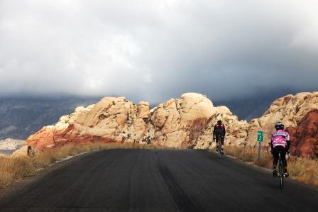
Riding a bicycle is a great way to enjoy the Red Rock Canyon National Conservation Area. The Red Rock Canyon Scenic Drive can provide an excellent workout and an opportunity to view the sights from a whole new perspective.
Road bicycles are allowed on all paved or unpaved roads and two-tracks; however no bikes are permitted on any trails accessed via the Scenic Drive.
All bicycles are required to follow motor vehicle road regulations on the Scenic Drive. Cyclists must obey the one-way direction of the Scenic Drive, may not ride side-by-side except to pass, and must keep to their lane of travel except when indicating a lane change to pass.
For information on E-Bike use, please visit E-Bike frequently asked questions.
- Mountain Biking
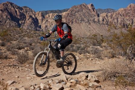
While road bikers can primarily be seen on the Scenic Drive, Red Rock Canyon also offers exciting opportunities for mountain biking. Bicycles are allowed on designated paved and unpaved roads and on trails designated for mountain bike use; however, bikes are not permitted on any trails off of the Scenic Drive or in designated wilderness areas. Bike-friendly trails can be accessed form two main trailhead and parking areas:
- Cottonwood/Late Night Trailheads off of State Route 160, approximately 4 miles (6.5 km) west of the State Routes 159/160 intersections (Cottonwood Valley Trails System)
- Mile maker 12 on Kyle Canyon Road/State Route 157 (Twilight Zone Trails)
Class 1, 2 and 3 e-bikes are permitted on designated mountain biking trails. Please recreate responsibly by following the guidelines below to ensure you and other visitors have a great time at Red Rock Canyon:
- Yield the right of way to other non-motorized recreationists. Move off the trail to allow horses to pass and stop to allow hikers adequate room to share the trail.
- Slow down and use caution when approaching another and make your presence known well in advance. Simply yelling "bicycle" is not acceptable.
- Maintain control of your speed at all times and approach turns with anticipation of someone around the bend. Be able to stop safely within the distance you can see down the trail.
- Stay on designated trails to avoid trampling native vegetation, and minimize potential erosion by not using wet or muddy trails or shortcutting switchbacks.
- Avoid wheel lockup. If a trail is steep enough to require locking wheels and skidding, dismount and walk your bike. Locking brakes contributes to needless trail damage.
- Ride directly over water bars or dismount and walk your bike. They are placed to direct water off the trail and prevent erosion.
- Respect public and private property, including trail use signs, no trespassing signs, and leave gates as you found them. If your route crosses private property, it is your responsibility to obtain permission from the landowner.
- Do not disturb wildlife or livestock.
- Do not litter. Pack out what you pack in and carry out more than your share whenever possible.
- Always be self sufficient. Your destination and travel speed will be determined by your ability, your equipment, the terrain, and the present and potential weather conditions.
- Do not travel solo in remote areas. Leave word of your destination and when you plan to return.
- Always wear a helmet.
- Ride only on roadways, trails, and slick rock. Biological soil crust is fragile and takes up to 50 years to recover from disturbance.
- Toilets in unimproved areas -- move off trail, and dig a one foot deep pit, cover after use.
- Horseback Riding
As long as there have been horses and burros in the Red Rock Canyon area, humans have used these steeds to explore and assist with settling the west. Now equines are primarily a means to enjoy and explore the wildernesses and relive a feeling of this region's pioneer past.
Horseback riding is limited to designated equestrian trails within Red Rock Canyon. The trails can be accessed form four main trailhead and parking areas utilized by equestrian riders:
- Cottonwood/Late Night Trailheads off of State Route 160, approximately four miles west of the State Routes 159/160 intersections (Cottonwood Valley Trails System)
- Exit of the Scenic Drive, two miles west of the entrance on State Route 159 (Scenic Drive Trails)
- White Rock Parking Area, located off of the Red Rock Canyon Scenic Drive (Scenic Drive Trails)
- Mile maker 12 on Kyle Canyon Road/State Route 157 (Twilight Zone Trails)
Visitors wishing to explore Red Rock Canyon on horseback, whether they bring their own horses or take advantage of the permitted guided equestrian tours, need to be aware and follow some simple rules. Suggestions specifically for horse can be found by visiting Leave No Trace.
Don’t have a horse? You’re in luck!
Red Rock Canyon has several permitted tour guides who can help you explore in a unique and exciting way. Novice to experienced riders are welcome to participate.- Camping
Campground Location
3293 Moenkopi Rd
Las Vegas, NV 89161Red Rock Canyon National Conservation Area has one developed campground. The Red Rock Canyon Campground is located 2 miles (3.2 km) east of the visitor center on State Route 159/Charleston Boulevard and one mile (1.6 km) south on Moenkopi Road. From the 215 Beltway, take exit 26 on W. Charleston Blvd, head west for 3.5 miles, turn left on Moenkopi Road and drive to the end (past the BLM Fire Station). The road leading to the campground is paved; however, roads within the campground are gravel.
Season, Hours of Operation and Weather
The Red Rock Canyon Campground is open 24 hours a day during open months. The campground is usually open from Labor Day to Memorial Day (September 1 – June 1) and closed over the summer. Inclement weather can occur at any time, with the possibility of freezing temperatures between December and February. It is a good idea to check the weather before you plan to arrive as temperatures can exceed 90 degrees in the spring/fall and winds can be very strong. Fires are forbidden during fire season (summer). The campground is located in the desert; therefore, shade is nonexistent unless the site has a shade structure. The campground experiences heavy usage from Mid-October through the end of November and during all of March and April. If you plan to arrive during these months, please have a contingency plan in the event that all sites are occupied.
Campground Amenities
53 individual campsites, 14 walk-to sites, six larger sites that will fit an RV, 7 group reservable campsites. Campsites are multiple use -- campers with tents and recreational vehicles are intermixed. Electrical, water and sewer hook-ups, showers and dump stations are not available.
There are 11 vault toilets. Drinking water is provided and limited to 4 liters per person per day. Firewood is not available.
Reservation System
Red Rock Canyon Campsite reservations can be made by visiting Red Rock Canyon Campground - Recreation.gov or by calling the national reservation hotline 1-877-444-6777. Reservations can be made up to six months in advance but not less than 48 hours of the desired arrival date. Camping rates are $25 per night for the standard and RV sites, $12 for the walk-to sites, and $80 for the group sites.
Walk-to campsites are reservable starting three days before your intended date to same day. One vehicle per site, please, and only five people per site. No additional parking is available.
Individual Standard Campsites
Each site has a picnic table, a fire ring, a grill except the walk-in sites. The walk-in sites have no fire ring and are closer together than regular sites.
The limit is 10 people per campsite. No refunds are given. No more than two vehicles per site. A sand tent 'pad' is provided and will fit approximately 2-3 small sized tents. Fees must be paid within 30 minutes of arrival at a self-pay kiosk.
America the Beautiful Senior and Access Pass holders receive a 50% discount for individual sites only.
Group Campsites
Reservations are required and can be made online by visiting Red Rock Canyon Campground - Recreation.gov or by calling the national reservation hotline 877-444-6777. Each site has a shade structure, picnic table, grill and fire ring. There is a minimum of 10, and maximum of 20 people per site. Up to eight vehicles are allowed per site.
Most sites have about 12 areas for tents, some of which will fit two smaller tents.
Campers are responsible to know and abide by all RRC rules and regulations
- You may not realign the rocks in the sites to accommodate larger vehicles. Please, do not park outside the assigned parking areas or on vegetation.
- Wood pallets for firewood are prohibited. No firewood is available on-site.
- The campground speed limit is 5 mph.
- Checkout is on or before 11 a.m.
- Check-in is at 2:00 p.m.
- The campground is not a day use area. Campers must be spend the night.
- There is limited cell phone service in the area.
- There is a 14-day limit in any 28-day period.
- No overflow parking available.
- Pets must be leashed and attended at all times. Waste must be cleaned up and thrown away in the dumpster.
- Quiet hours are from 10 p.m. until 6 a.m. (no generators, radios, music players etc. during this time).
- No public transportation is available to the campground.
- Commercial/competitive/or instructional activities in or outside the campground and in the conservation area may require an additional permit.
- In order to ensure the public safety and protection of resources, organized group use and guided climbing and/or guided hiking may require a separate Special Recreation Permit or Letter of Agreement. These authorizations allow specified recreation use of the public lands. They are issued to manage visitor use, protect natural and cultural resources, achieve the goals and objectives of the field office recreation program as outlined in a land use plan, and authorize the types of recreation uses. Group size must be limited to 12 people or less on hiking trails and climbing routes.
Campground Hosts
Campground hosts live on-site and volunteer for the Bureau of Land Management. They are there to assist you in making your visit as enjoyable as possible.
- Backcountry Camping
Backcountry camping is allowed within the core area of Red Rock Canyon National Conservation Area above 5,000 feet (1500 m). A paperless permit is required and can be obtained online by visiting Red Rock Canyon Backcountry Late Exit Pass - Recreation.gov. People can request a permit by clicking the "Buy a Pass" button on the website. Backcountry camping/Late exit permits are free, but a 50-cent processing fee will be charged.
The backcountry area is remote with no drinking water or firewood for campfires. Campers must select a previously disturbed campsite and must camp father than 200 feet (60 m) from springs and riparian areas.
There is no developed trail system in the backcountry. Ground fires are prohibited, but camping stoves are permitted. To minimize conflicts with wildlife, pets should be on a leash and pet waste must be cleaned up.
Please carry out all trash. Litter is an eyesore and a hazard to wildlife. Trash cans are located at parking lots along the Scenic Drive and in Willow Spring Picnic Area.
There is also one developed campground at Red Rock Canyon.
Whether in the backcountry or developed campground, all stays are limited to 14 days.
- Off-Highway Vehicles
Off-highway vehicle travel is a fun activity if done safely. Off-highway driving in Red Rock National Conservation Area is limited to designated roads only and cross-country travel is prohibited to provide for public safety, and preservation of the area.
Four-wheel drive (4X4) high clearance vehicles are recommended on all of the unpaved designated roads. The Red Rock Canyon Scenic Drive is limited to street licensed vehicles only.
Some great off-roading opportunities include:
- Rocky Gap Road - An extremely rough, four-wheel drive road. Expect narrow road conditions with numerous washouts. Not recommended for passenger cars or other low clearance vehicles. Like all off-road trips, preparation and caution are highly recommended.
- Cottonwood Valley - An undeveloped area that features several unpaved routes. Be prepared for washouts and sandy areas.
- La Madre Foothills Recreation Area - located to the north of the Scenic Drive, this undeveloped area has a network of 4X4 trails. Please recreate responsibly and stay on designated routes.
- Harris Springs - this area can be accessed from SR-157 (Kyle Canyon Rd) and has a network of 4X4 routes. This also connects to Forest Service lands to the west and the La Madre Foothills to the east and south.
Red Rock Canyon has several permitted tour guides who can help you explore in four-wheel drive vehicle.
To help ensure a safer and more responsible off-highway vehicle experience within Red Rock Canyon, please take a moment to check out Tread Lightly!
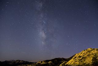
- Night Skies
Located only miles from Las Vegas, yet set among dark mountains and starry skies, Red Rock Canyon is an excellent place to view the night sky and related astronomical objects.
Night Skies
The darkest spots in the Conservation Area are located off of State Route 160 south of the Visitor Center. Trailheads at Cottonwood Valley and Late Night are located in dark, flat, expansive areas of Red Rock Canyon, and thus provide wide open views of the night sky. Before going, be sure to consult a sky chart, or your favorite website to determine what stars and planets are visible.
Meteor Showers
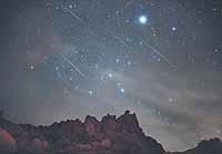
These dark areas also make for excellent meteor shower viewing. A wide variety of objects besides planets orbit the sun. These objects, usually comets or asteroids, may have orbits of thousands of years. When they finally approach the sun, they heat up and partially disintegrate, leaving a trail of dust and debris. As the earth also orbits the sun, it occasionally passes through these left behind debris trails. As we do, the space debris burns up as it enters the Earth’s atmosphere, causing a meteor shower.
The best time see meteor showers are early in the morning, a few hours before sunrise. In the early morning the earth is turning towards the sun, and thus toward a warmer section of space. This warm area contains more meteors than in the evening when we are turning towards cold space.
Sunrises and Sunsets
Sunrises and Sunsets in the desert are interesting; visitors can see much farther in the dry desert air, towering mountains present complex light and shadows, but the lack of clouds can limit sky color. To see the best sunsets and sunrises, look for partly cloudy days and a location where you can remain far away from the appropriate horizon.
The Red Rock Overlook and the Highpoint Overlook are the best places to view sunrises and sunsets, as both points offer wide views to the east and west. The Red Spring Boardwalk also offers excellent views to the east. These areas are open at 6:00 a.m., please check closing times as they change during the year.
Best Places to View the Full Moon
Hiking under a desert full moon is a special experience. Generally, flat, open areas are best to view the moon. The First Creek and Oak Creek areas off of State Route (SR) 159 are excellent trails. Because mountains separate Red Rock Canyon from the Las Vegas Valley to the east, it is difficult to find a spot to see the moon initially rise over the eastern horizon. However, there are spots near SR 159 and the Moenkopi road near the Red Rock Campground that patient visitors can observe the moonrise. Remember, the full moon always rises at sunset, making for a once-a-month opportunity to photograph both the full moon and the colors of sunset.
Guided Public Star Parties and Hikes
Red Rock Canyon works in partnership with the Las Vegas Astronomical Society to provide “Star Parties” for the public. These events include constellation tours, telescope viewing, and interpretive presentations. Star parties occur at various times of the year and coincide with astronomical events, such as the new moon, full moon, and meteor showers.
The Las Vegas Astronomical Society provides various types of telescopes to view night sky objects. The members are amateur astronomers and are very happy to answer any questions, from equipment to celestial objects.
Red Rock Canyon also offers “Full Moon Hikes” led by interpretive park rangers and naturalists from the Southern Nevada Conservancy. The hikes take place on easy trails with little elevation gain. These hikes provide an opportunity to discover the night sky in a small group setting.
For dates, please visit Red Rock Canyon - Southern Nevada Conservancy or the Las Vegas Astronomical Society
- Geocaching
Geocaching is an outdoor treasure finding game using GPS-enabled devices. By using specific GPS coordinates, a geocacher attempts to find a geocache, a container with a log or an item inside, hidden at that location. Although fun and appropriate for some locations, it is not allowed at Red Rock Canyon National Conservation Area. By going off established trails, disturbing natural resources and abandoning property (a geocache) our public lands can suffer. One option for intrepid geocachers is to search for "virtual caches," "earth caches," and USGS Benchmarks, which help minimize the impact to Red Rock Canyon.
- Target Shooting and Hunting
Target shooting can be a fun activity if done safely and is generally allowed on BLM-managed public lands. After public input, Red Rock Canyon National Conservation was closed to target shooting in 1993 to provide for public safety.
Following Nevada Department of Wildlife and Red Rock Canyon National Conservation Area Supplementary Rules, hunting and trapping are allowed only in specific areas above 5,000 ft (1500 m)
Visitors are not allowed to possess loaded weapons in Red Rock Canyon unless involved in hunting in accordance with local, state and federal regulations.
A hunting map is available.