
Burning operations planned for military training lands in Interior Alaska to reduce wildfire threat
Organization:
BLM Office:
Media Contact:
FAIRBANKS, Alaska –The Bureau of Land Management Alaska Fire Service (BLM AFS) and 11th Airborne Division (11th ABD) will soon implement multiple prescribed fires on military training lands in Interior Alaska. Burning could begin as early as Saturday, May 6, starting with woody debris piles and dead grass within the Donnelly Training Area. As conditions allow, prescribed burning in the Donnelly Training Area (DTA) near Delta Junction, the Yukon Training Area (YTA) near Eielson Air Force Base, and on Fort Wainwright (FWA) land near Fairbanks may continue through May 31.
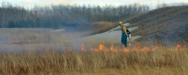
Prescribed burns are fires that are intentionally set under controlled conditions to reduce dry and dead grass and lower the risk of wildfires that could impact nearby communities, resources, facilities and military training. Removing hazardous fuels during the spring, when conditions are moderated, allows for the greatest degree of control and the lowest risk for negative impacts, such as smoke. The woody debris piles were created to reduce wildfire risk within training areas and to make the area more accessible to firefighting forces.
While smoke from prescribed fires may be visible from various points in the surrounding communities, their potential impact on the public is considered at all stages of prescribed fire planning. The BLM AFS and 11th ABD work closely with the Alaska Department of Environmental Conservation Division of Air Quality and the National Weather Service to mitigate potential impacts. There are also procedures in place to halt ignitions if weather conditions, such as wind direction, become unfavorable.
The annual prescribed burning is planned at the following locations:
- DTA: Several locations between 25 miles west and 15 miles south of Delta Junction.
- YTA: Several locations between 5 miles north and 20 miles east of Eielson Air Force Base.
- FWA: Small Arms Complex, immediately southeast of Fairbanks.
The exact timing of later prescribed burning will depend on the snow melting and weather conditions. Subsequent releases specific to each area will provide more precise estimates of the time frames.
Photos of past prescribed burning on military training lands in Interior Alaska are on the BLM AFS’s Flickr page. Find maps for the areas identified for prescribed burning this spring on the Alaska Wildland Fire Information (akfireinfo.com) website.
-BLM-
Need public domain imagery to complement news coverage of the BLM Alaska Fire Service in Alaska? Visit our Flickr channel!
Learn more at www.blm.gov/AlaskaFireService, and on Facebook and Twitter.
The BLM manages about 245 million acres of public land located primarily in 12 western states, including Alaska, on behalf of the American people. The BLM also administers 700 million acres of sub-surface mineral estate throughout the nation. Our mission is to sustain the health, diversity, and productivity of America’s public lands for the use and enjoyment of present and future generations.