
Bureau of Land Management invites public input on the Amargosa Wild and Scenic River Comprehensive River Management Plan
Organization:
BLM Office:
Media Contact:
BARSTOW, Calif. – The Bureau of Land Management (BLM) Barstow Field Office is opening the public scoping period for the development of the Amargosa Wild and Scenic River Comprehensive River Management Plan (plan). Members of the public are invited to attend a virtual presentation on May 12, 2021 at 4 p.m. via Zoom to provide scoping comments during the 30-day period which will close on June 1, 2021.
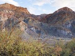
“Often referred to as the ‘Crown Jewel of the Mojave Desert,’ the Amargosa is the only free-flowing river in the Death Valley region of the Mojave, providing a rare and lush riparian area in the desert,” said Katrina Symons, Barstow Field Manager. “The BLM is asking the public to assist with the development of the vision for the management of this amazing resource.”
The original 26.3 miles of the Amargosa River were designated as a wild and scenic river under the Omnibus Public Lands Management Act of 2009. In 2019, the John D. Dingell Jr. Conservation, Management and Recreation Act added an additional 7.5 wild and scenic river miles north of the originally designated river segment.
The Wild and Scenic Rivers Act of 1968 requires a plan be prepared by the river-administering agency to establish long-term management direction for a wild and scenic river. The plan will identify implementation goals and develop implementation actions to meet those goals. The plan will also identify the outstandingly remarkable values for the Amargosa River, as well as outline management direction for protecting and enhancing the river’s Outstandingly Remarkable Values, free-flowing condition, and water quality.
Pursuant to the Wild and Scenic Rivers Act of 1968, when a wild and scenic river is designated, a quarter-mile buffer on either side of the river is considered as part of the designation. During the planning process, this boundary may be adjusted, and members of the public are invited to propose suggested modifications to this interim boundary and identify any resource concerns and management objectives for the plan. Comments that help further define the scope of alternatives, environmental impacts and other resource issues are also encouraged.
Substantive written comments may be mailed to Chris Otahal, Barstow Field Office Wildlife Biologist at 2601 Barstow Road, Barstow, CA 92311 or provided via e-mail at: [email protected] by June 1, 2021. Due to COVID-19 concerns, an informal web-based presentation will replace an in-person meeting and take place via Zoom at 4 p.m. on May 12, 2021 at: https://blm.zoomgov.com/j/1603556679?pwd=Yy9tOVVUU3JLWVV6cmFZa0ZoYjFNUT09
For additional project information contact Chris Otahal at the email address above.
The BLM manages about 245 million acres of public land located primarily in 12 western states, including Alaska, on behalf of the American people. The BLM also administers 700 million acres of sub-surface mineral estate throughout the nation. Our mission is to sustain the health, diversity, and productivity of America’s public lands for the use and enjoyment of present and future generations.