
BLM reduces risk of wildland fire with controlled burn in the ‘Inimim Forest
Organization:
BLM Office:
Media Contact:
EL DORADO HILLS, Calif. — The Bureau of Land Management will conduct a controlled prescribed burn, as soon as next week, on up to 1,800 piles of tree branches and brush on roughly 75 acres in the ‘Inimim Forest, east of North Columbia in Nevada County. Timing of the pile burn will depend on weather conditions, air quality, resource availability and onsite observations.
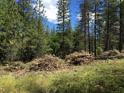
Wildland fire crews will burn piles on the Shields Camp and Bear Tree parcels. The burn piles are a result of shaded fuel breaks after crews carefully thinned dense hazardous tree cover and removed underlying brush in strategic locations to improve forest health. The piles consist of brush, chaparral, Douglas fir, ponderosa pine, black oak, madrone and manzanita tree branches.
This treatment is part of the ‘Inimim Forest Restoration Project, a multi-year effort to reduce the available hazards that can fuel wildland fire, protect communities in the wildland-urban interface and improve fire resiliency.
The BLM, along with its partners, has an important role to play in reducing the climate threat on public lands across the United States. The prescribed burn is expected to take about a month and is being done as a joint effort of the BLM, CAL FIRE, California National Guard, North San Juan Fire Department and the Yuba Watershed Institute. The burn is being closely coordinated with the Northern Sierra Air Quality Management District.
The public is advised to use caution when driving on Lake City/Shields Camp Road and be prepared to stop for firefighters and emergency vehicles. Smoke may be visible in North Columbia, Lake City and North Bloomfield.
The ‘Inimim Forest is nearly 2,000 acres of BLM-managed public lands intermingled with private land on the San Juan Ridge, a 30-mile-long narrow ridge ranging from about 2,500 to 3,800 feet elevation between the South and Middle Yuba rivers.
Updates on this prescribed burn will be provided using the #RxBurn by the BLM through its social media accounts on Facebook and Twitter. For more information on the prescribed fire, please call the Mother Lode Field Office at 916-941-3101 or email the office at [email protected].
The BLM manages about 245 million acres of public land located primarily in 12 western states, including Alaska, on behalf of the American people. The BLM also administers 700 million acres of sub-surface mineral estate throughout the nation. Our mission is to sustain the health, diversity, and productivity of America’s public lands for the use and enjoyment of present and future generations.