
BLM to conduct prescribed burning in Butte County
Organization:
BLM Office:
Media Contact:
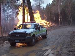
REDDING, Calif. — Fire crews from the Bureau of Land Management will conduct prescribed burning to create fuel breaks on BLM-managed public lands along Garland and Doe Mill roads in Butte County, on March 3 and 4, as part of the ongoing Butte Forest Thin Project. The project area, roughly 220 acres, is about three miles east of Forest Ranch and about a mile east of State Route 32. Smoke will be visible from the Forest Ranch and DeSalba communities and portions of State Route 32 in the Forest Ranch area.
“We have been conducting thinning and prescribed fire in this area for the past several years,” said Jennifer Mata, manager of the BLM Reding Field Office. “This project enhances safety for firefighters and the public who would use these roads for evacuation in the event of a wildland fire and improves wildlife habitat in the Butte Creek watershed.”
Crews will ignite the fires only when weather and fuel conditions allow for safe and successful burning and smoke dispersion. The project will be conducted in accordance with a burn plan that details allowable conditions and required personnel. The Redding Field Office plans to take advantage of additional burning opportunities during favorable conditions throughout the spring.
The BLM manages about 245 million acres of public land located primarily in 12 western states, including Alaska, on behalf of the American people. The BLM also administers 700 million acres of sub-surface mineral estate throughout the nation. Our mission is to sustain the health, diversity, and productivity of America’s public lands for the use and enjoyment of present and future generations.