
White Mountains National Recreation Area Georeferenced PDF Map
New! Expanded Georeferenced PDF Map for summer recreation (May 1 - October 14).
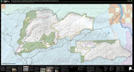
The map include BLM recreation sites, routes and motor vehicle limitations for the White Mountains National Recreation Area and Steese National Conservation Area. Summer route and area designations apply May 1 - October 14.
Stay tuned for a new expanded map for winter recreation.
Click the link below to view and download the map. It is a large file and may need time to load.
Download Files
Publication Date
Region
Alaska
Organization
Collection: Public Room
Category: Map
Keywords
Georeferenced
Map
Recreation