
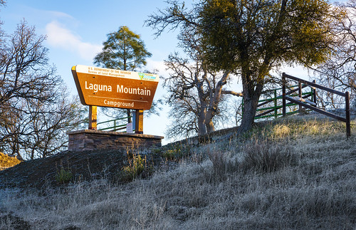
Laguna Mountain | California
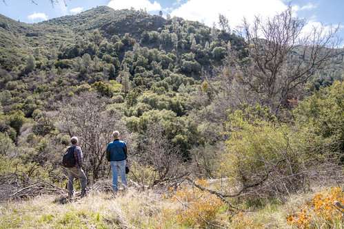
The Laguna Mountain Area consists of somewhat rugged terrain with rolling hills covered in dense brush. The area's vegetation is characterized by classic chapparal habitat, oak forests, and grassy meadows. Laguna Creek flows through the area most of the year, accompanied by a series of scenic waterfalls in the Gorge.

CAMPING
Campgrounds:
There are campgrounds at Laguna Mountain and Upper Sweetwater. Each campground features several campsites which are equipped with level RV pads, fire rings, shade structures, picnic benches, vault toilets, and a kiosk providing an interpretive panel, a map, and information about the area. Persons may camp within designated campgrounds or on undeveloped public lands not closed to camping within the Hollister Resource Area for a total period of not more than fourteen days during any three-month period. There is no electricity, running water, or trash collection at the campsites. Please utilize good camping ethics, and remember to pack out your garbage when you leave.
Dispersed Camping:
Dispersed camping is also available, although there is no camping within 200 yards of any wildlife watering improvement. You must park within 15 feet (roughly one vehicle length) of any roadway when camping or leaving a vehicle unattended to minimize habitat and vegetation impacts. Please remember to bring a shovel with you for both personal sanitation and fire prevention purposes.
TRAILS
There are three trailheads, one each at Laguna Mountain, Sweetwater, and Short Fence.
From the Laguna Mountain Campground and Trailhead, a 2.5 mile out and back hike will reward hikers, mountain bikers, and equestrians with a view of a series of waterfalls flowing from Laguna Creek. Begin your adventure by following the fire break road for half of a mile to the brown fiberglass trail marker. After turning right onto the trail at the marker, continue on the trail as it follows the gentle contours of the chapparal covered slope until you cross the creek at the bottom of Miller Canyon. Use caution as you cross Laguna Creek and take time to observe the changes in your surroundings. The trail will take you above the creek through oak forest and grassy meadows as you slowly climb to the falls overlook. From the overlook, a short scramble will take you to the base of the falls. To return to the trailhead, there are two options. A short scramble back to the trail will take you directly back to the trailhead. For those seeking more adventure, explore Laguna Creek on your way back to the trail. This will involve off-trail travel, often over slippery rocks. Be mindful of snakes, ticks, and poison oak.
HUNTING
There are three main types of hunting available, including upland game bird, small game, and big game like deer and wild pigs. Varmint (non-game) hunting is also allowed. The California Department of Fish and
Wildlife regulates the hunting seasons for different species and the types of firearms allowed for use. Please be aware that this region is home to the California Condor and affects non-game hunting.
You may be able to find pig, deer, upland game birds, other small game and varmints at Laguna Mountain.
TARGET SHOOTING
There are no designated target shooting areas in the Central Coast Field Office area, however, Public Lands managed by the Bureau of Land Management are open to target shooting except when prohibited by other applicable laws and regulations.
While target shooting on BLM lands you must:
- Use legal weapons and ammunition
- Employ a safe backstop (hill) within close proximity behind the target
- Remove all your targets, gun shells, clay pigeons, and any and all items used for your target shooting
You may not:
- Shoot within 150 yards of residences, structures, or developed areas (i.e. day use areas)
- Shoot onto private lands
- Shoot across a roadway or trail
- Shoot at hazardous materials such as propane tanks or paint cans
- Shoot at trees, facilities, signs, or outbuildings
Call or email the Central Coast Field Office for more information on shooting safely and be sure to visit the State of California's Department of Justice (DOJ) Bureau of Firearms web page.
Contact Us

Activities


Addresses
Directions
From Hollister take State Highway 25 south approximately 12.5 miles south of Pinnacles National Park. Turn east (left) onto Coalinga Road. Access points begin approximately 9 miles from the State Highway 25 and Coalinga Road junction.
Fees
No Fee