
Rock Slide on U.S. Route 101 Forces King Range National Conservation Area Visitors to use Alternate Route
Organization:
BLM Office:
Media Contact:
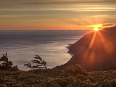 ARCATA, Calif. – Outdoor enthusiasts wishing to visit the Bureau of Land Management’s (BLM) popular Lost Coast Trail at King Range National Conservation Area (NCA) will need to find another route than by traveling U.S. Route 101 (also known as U.S. Highway 101). The route is temporarily closed due to a rock slide north of Leggett, California, about 15 miles south of Garberville.
Hikers, backpackers and campers should instead travel north on Interstate Highway 5 to California State Route 36, or California State Route 299, to reach the King Range NCA.
The King Range NCA remains open to the public. Visitors coming from the southern California will need to allow extra travel time. The BLM encourages visitors to check the California Transportation website for the latest details, http://www.dot.ca.gov/cgi-bin/roads.cgi?roadnumber=101&submit=Search, or https://www.facebook.com/CaltransD1/.
Just a reminder, the BLM now requires permits by reservation for overnight use in the King Range Wilderness and Backcountry Management Zone, which are available at www.recreation.gov. Reservations cost $6 per permit. Day-use visitors or campers outside the wilderness or backcountry areas do not need a permit.
The new permitting requirement will help the BLM manage the number of visitors to the King Range Wilderness and Backcountry Management Zone for overnight use to 60 entries per day, during the peak season of May 15 to September 15, and 30 entries per day during the non-peak season of September 16 to May14.
Overnight use has increased by more than 150 percent since the King Range Wilderness was designated in 2006.
The BLM implemented this permit reservation system after receiving extensive public input for more than a decade, as part of the King Range National Conservation Area Resource Management Plan and the King Range Wilderness Management Plan.
The King Range National Conservation Area is located about 230 miles north of San Francisco and 60 miles south of Eureka. All roads leading to the King Range are narrow, steep and winding. Allow plenty of time between destinations, have a full tank of gas, and be alert to oncoming traffic. For more information about the King Range NCA, visit https://www.blm.gov/nlcs_web/sites/ca/st/en/prog/nlcs/King_Range_NCA.html.
The BLM manages about 245 million acres of public land located primarily in 12 western states, including Alaska, on behalf of the American people. The BLM also administers 700 million acres of sub-surface mineral estate throughout the nation. Our mission is to sustain the health, diversity, and productivity of America’s public lands for the use and enjoyment of present and future generations.