
Public Land visitors can help monitor conditions by using ‘chronolog’ sites
Organization:
BLM Office:
Media Contact:
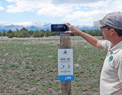
ALTURAS, Calif. — Public land adventurers can help the Bureau of Land Management monitor the condition of lands and resources by using new “chronolog” stations now functioning on three sites in northeast California and northwest Nevada.
The BLM’s Applegate Field Office has collaborated with partners to install the stations at sites where research and restoration projects are underway. When visiting these sites, people can use a cell phone or tablet to snap a photo and then upload it to the chronolog site, where it will become part of a time lapse video.
“We hope this will be a good way to get people engaged in the everyday science that the BLM and our partners undertake to improve public lands and natural resources,” said Craig Drake, manager of the BLM Applegate Field Office based in Alturas.
The following chronolog sites are active on public lands managed by the BLM Applegate Field Office:
- Prescribed Fire: This site is along the Barrel Springs Backcountry Byway about 10 miles northeast of Fort Bidwell, Calif. (coordinates: 119°57'31.006"W, 41°53'43.719"N). The BLM and University of Utah are studying fire effects on an edible plant called yampah, or epos, important to native people.
- Spring Restoration: The monitoring site is a half-mile south of the Buckhorn Backcountry Byway south of Cedarville, Calif. near the California-Nevada state line (coordinates: 119°55'38.923"W, 40°52'37.243"N). At this location, the BLM is studying the effects of a riparian fence enclosure, native plant seeding, and removing encroaching juniper trees to improve water quality and quantity from the spring.
- Meadow Restoration: The chronolog site is at Fitzhugh Creek Meadows, about 11 miles south of Alturas, Calif. in an area known as the Likely Tablelands (coordinates: 119°55'38.923"W, 40°52'37.243"N). It will be active starting June 14. The best access is from Modoc National Forest Road 5. A high clearance four-wheel-drive vehicle is recommended. Here, the BLM and CalTrout have installed beaver dam analogs that mimic the function of beaver dams to improve the meadow’s hydraulic functions such as water retention.
The BLM recommends checking on conditions before heading out to one of the sites. Information is available from the BLM Surprise Field Station, 530-279-6101.
Chronolog is a tool used by organizations to create crowd sourced time lapse videos to monitor the environment and engage communities in science. More information, including a map of sites, is available here: www.chronolog.io.
The BLM manages about 245 million acres of public land located primarily in 12 western states, including Alaska, on behalf of the American people. The BLM also administers 700 million acres of sub-surface mineral estate throughout the nation. Our mission is to sustain the health, diversity, and productivity of America’s public lands for the use and enjoyment of present and future generations.