
Heavy snowpack increases safety concerns for BLM Uncompahgre recreational users
Organization:
BLM Office:
Media Contact:
MONTROSE, Colo. — Heavy snowpack this year means that stream flows could be particularly high, making recreation more hazardous. Creeks on the east side of the Uncompahgre Plateau are the most likely to experience high flows. Recreational users should avoid crossing fast-moving waters in flood-prone areas such as Spring Creek, Dry Creek, Roubideau Canyon, and Escalante Canyon.
“Snowpack on Columbine Pass is well above normal,” said Uncompahgre Field Office Hydrologist Jedd Sondergard. “For creeks coming off the Uncompahgre Plateau, flow typically peaks around May 1—about a month sooner than rivers like the Gunnison and San Miguel. I expect we could see high flows beginning the middle of April and lasting through the end of May, depending on how fast it warms up.”
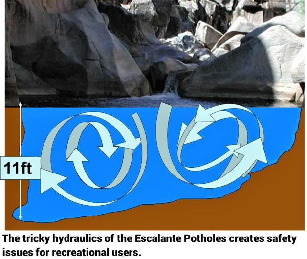
Perhaps of greatest safety concern is the Escalante Potholes area. Located about 12 miles up Escalante Canyon in the Dominguez-Escalante National Conservation Area (NCA), the Potholes attracts picnickers and swimmers. During spring runoff, the Potholes provides unique recreational opportunities, with extreme kayakers drawn to the up to Class V+ rapids. However, hidden currents in the pothole formations can catch and hold a person under water, regardless of their strength or swimming ability. The BLM has found that most drowning deaths at the Potholes have been related to jumping or diving into the potholes, which is a prohibited activity.
“The Escalante Potholes could remain hazardous for a longer period this year,” noted NCA Manager Amber Koski. “Tricky hydraulics coupled with young people nearing the end of the schoolyear can make for a dangerous situation. I would urge parents to be aware of the risks and, if you hear your kids talking about the Potholes, be prepared to discuss the safety considerations.”
Kiosks and signage at the three-acre site warn visitors of the dangerous conditions. The BLM and Delta Sheriff's Office attempt to coordinate patrols in order to increase public safety. Personal responsibility is especially critical given that radio and cell phone reception in the canyon is often poor to non-existent. Poor reception has played a role in Potholes fatalities by delaying the ability to call for help.
Hazards associated with the Potholes were recognized at least as far back as the 1989 Uncompahgre Basin Resource Management Plan, when the Escalante Canyon was being considered for designation as an area of critical environmental concern. According to the evaluation, the Potholes area has been an “attractive nuisance where visitors have been hurt or killed by jumping from surrounding cliffs into small pools. Cliff jumping has resulted in broken bones, concussions, and drownings.”
The BLM manages about 245 million acres of public land located primarily in 12 western states, including Alaska, on behalf of the American people. The BLM also administers 700 million acres of sub-surface mineral estate throughout the nation. Our mission is to sustain the health, diversity, and productivity of America’s public lands for the use and enjoyment of present and future generations.