
BLM plans pile burns in Catron County
Organization:
BLM Office:
Media Contact:
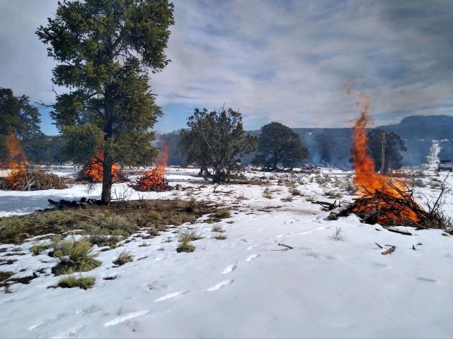
SOCORRO, N.M. — The Bureau of Land Management (BLM) Socorro Field Office plans to burn piles of juniper and piñon slash in three locations in Catron County. Weather permitting, the burns will take place between now and Dec. 31.
“The BLM created the piles as part of thinning projects to reduce wildfire risk, improve ecosystem health, improve wildlife habitat and help protect local communities from wildfire,” said BLM Prescribed Fire and Fuels Specialist Lino Baca.
The Wild Horse Slash Pit is a cooperative effort with the local community to provide a place for disposal of woody debris from private lands. Coordination and notification of the pile burns by district fire personnel includes the Wild Horse Landowners’ Association, local fire departments, adjacent landowners, range allotment permittees, and others.
Details on each location and size are as follows:
- Alamocita Pile Burn: 135 acres, located east of Pie Town and approximately 10 miles north of Highway 60.
- Tank Canyon Pile Burn: 215 acres, located approximately 25 miles north of Pie Town and about two miles east of the York Ranch Road in the vicinity of the Wild Horse subdivision.
- Wild Horse Slash Pit: located off the Wood Camp Road.
Active ignition on each location will take one to five days, with some smoke visible in the burn areas for up to a week after ignition operations are completed. Site-specific weather forecasts will be requested and obtained from the National Weather Service prior to ignition to ensure the burn is within prescription to help minimize the fire and smoke risk to the public. Firefighters will monitor the burns until there is no visible smoke. Fire personnel will continue to visit the site to check for heat and smoke and that the perimeter of the unit is secure. Once smoke and heat are no longer present, the prescribed fire will be declared out.
For added public safety, prescribed fire signs will be posted on Highway 60 and county roads near the burn locations. Motorists should be aware that smoke from the fires could reduce visibility for brief periods of time on Highway 60 and York Ranch Road. In addition, caution is advised when driving in the areas due to the presence of fire personnel and equipment along roads.
Prior to and during all prescribed fires, fire managers coordinate with the New Mexico Environment Department and follow all air quality regulations. People who may have health conditions that make them vulnerable to smoke exposure can get information about smoke and protecting their health at: https://nmfireinfo.com/smoke-management/. In addition, to NM Environment Department’s air quality monitoring and Airnow.gov are resources for viewing sources of smoke and other factors affecting air quality
Please contact the BLM Socorro Field Office at (575) 835-0412 with any questions about these projects. For more information about this and other prescribed burn operations, as well as wildland fire updates, please visit www.nmfireinfo.com.
The BLM manages about 245 million acres of public land located primarily in 12 western states, including Alaska, on behalf of the American people. The BLM also administers 700 million acres of sub-surface mineral estate throughout the nation. Our mission is to sustain the health, diversity, and productivity of America’s public lands for the use and enjoyment of present and future generations.