
Gila Box Riparian National Conservation Area Map
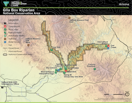
This map depicts major roads, points of interest, and facilities of Gila Box Riparian National Conservation Area as administered by the Bureau of Land Management (BLM).
The 23,000-acre Gila Box Riparian National Conservation Area includes four perennial waterways, the Gila and San Francisco rivers and Bonita and Eagle creeks. This region is a very special riparian ecosystem abounding with plant and animal diversity. A canyon section, known as the Gila Box, is composed of patchy mesquite woodlands, mature cottonwoods, and sandy beaches.
No warranty is made by the BLM as to the accuracy, reliability, or completeness of these data for use or for purposes not intended by BLM.
Download Files
Publication Date
Region
Arizona
Gila DO
Safford FO
Organization
Collection: Public Room
Category: Map
Keywords
Gila Box Riparian National Conservation Area
Map