
Virgin River Complex Wild and Scenic Rivers
BLM-Utah manages 11 river segments totaling 19 miles within the Virgin River drainage and all are classified as "wild". Each of the segments flows into or out of Zion National Park and a majority are within wilderness areas that were also designated in the 2009 Omnibus Public Land Management Act (Public Law 111-11). These river segments are managed under a Comprehensive Management Plan in concert with the National Park Service. The rugged terrain and lack of nearby roads makes the majority of the BLM-administered river segments difficult to access.
The Virgin River and its tributaries provide a unique and intact habitat for four native fish species, including the Virgin spinedace, which only exists in the Virgin River system, and the flannelmouth sucker, desert sucker and speckled dace. The Zion stonefly (Isogenoides zionensis), an important component of the food web, is also found along the Virgin River and its tributaries.
The extensive cover, availability of water and a contiguous landscape of wildlands, creates habitat for a wide variety of animals. Mule deer, elk, desert bighorn sheep, mountain lions, bobcats, badgers, marmots, ringtails, Mexican spotted owls and the endemic Zion snail can all be found in the region.
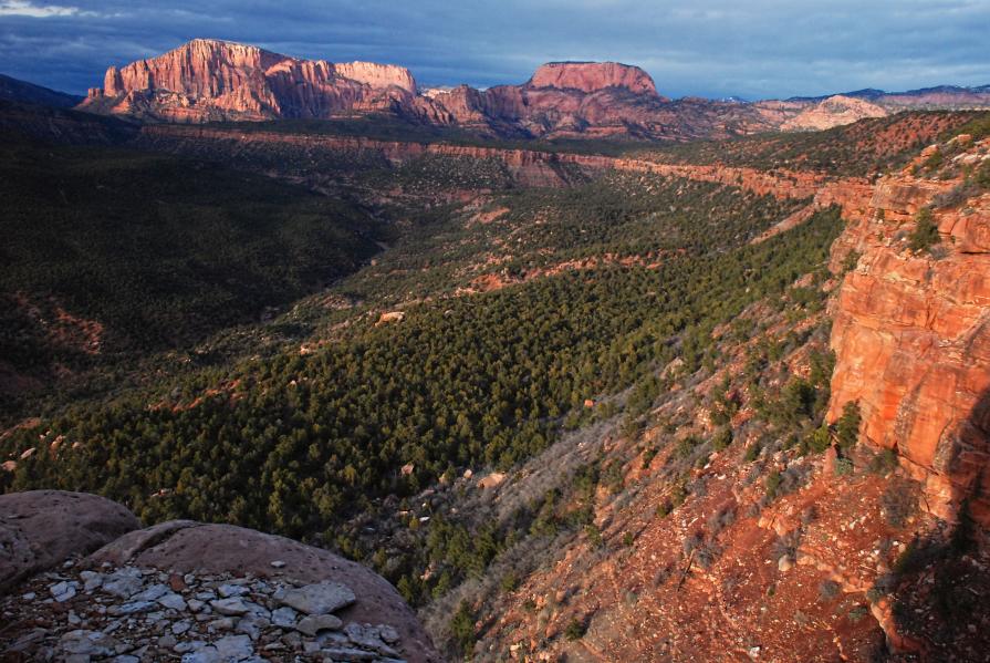
The Virgin River and its tributaries create diverse opportunities for views of the river’s unparalleled scenery. The river creates a landscape of cross-bedded sandstone cliffs, towering thousands of feet above the canyon floor. These canyons offer world-class opportunities for canyoneering, rock climbing, hiking and wilderness experiences, and providing visitors from around the world a chance to develop personal and lasting connections with the river within some of the most unique water-carved desert canyons in the region.
Find out more about other wild and scenic rivers on the Utah National Conservation Lands page or on the wild and scenic rivers program page.
- Beartrap Canyon
Beartrap Canyon is largely rugged and steeply sloped and contains the headwater area for many tributaries that flow through the Kolob Terrace. The terrain consists of a sandstone finger of a mesa at the upper reach of Beartrap Canyon. At a top elevation of 7,500 feet, both the mesa top and canyon bottom sustain Utah juniper and ponderosa and pinyon pine trees. The canyon is also a designated wilderness area of 40 acres and directly adjacent to a larger wilderness area in Zion National Park. Despite its small size, a wide variety of wildlife lives here because of its proximity to adjacent wilderness and other relatively undisturbed lands. Beartrap Canyon features high cliffs of Navajo sandstone, known to be the world’s highest sandstone cliffs and slot canyons, which are deep and exceptionally narrow vertical walled canyons. Springs that discharge from the Navajo sandstone aquifer in these canyons support a large number of rare and endemic species.
Length (miles on BLM surface): 0.08 mile
- Deep Creek
Deep Creek is aptly named for the deeply incised stream channel that it has carved through the Deep Creek Wilderness of northeastern Washington County. It begins on BLM-administered lands and continues south through Zion National Park to its confluence with North Creek, one of the major tributaries to the Virgin River. The spectacular geologic formations through which Deep Creek flows are one of its identified values. Flowing unimpeded over the millennia, this narrow perennial stream has down cut through 2,000 feet of Jurassic-age Navajo sandstone, sculpting narrow canyons, chutes and waterfalls and exposing brilliantly colored sedimentary deposits. Lush riparian vegetation is sustained along the stream channel by surface flows and discharge from the aquifer created by the Navajo sandstone. Numerous bird species can be observed in the wilderness, with some of the more interesting being golden eagles, screech owls, chukars and wild turkeys. The remote canyons of the Deep Creek Wilderness provide suitable nesting habitat for the Mexican spotted owl, a threatened species.
Length (miles on BLM surface): 4.83 miles
- Goose Creek
Goose Creek flows through wilderness at the start of the steep and deep Goose Creek Canyon to its junction with the North Fork of the Virgin River. The landscape is typical of high elevation desert—dense tree stands on the slopes and thick riparian vegetation thriving in the canyon’s steep walled shade. A mix of ponderosa and pinyon pine and Utah juniper grow on top of the sandstone cliffs. This creek features Navajo sandstone exposures, a remnant of the world’s largest sand dune desert, river-carved canyons forming the world’s tallest sandstone cliffs, narrow slot canyons, hanging waterfalls, springs and seeps. This dynamic geologic system creates a diverse landscape that support a variety of species and ecological communities.
Length (miles on BLM surface): 0.42 mile
- Kolob Creek
Kolob Creek begins atop the Kolob Plateau at 9,200 feet on the slopes of Kanarra Mountain. It flows across open meadowland for several miles through the Kolob Reservoir and basalt plateau before entering a canyon and meeting up with the North Fork of the Virgin River. Kolob Creek Canyon combines with Deep Creek and the Virgin River Canyons to form Zion Canyon. Kolob Creek has the longest stretch of narrows of these three canyons.
Length (miles on BLM surface): 2.04 miles
- La Verkin Creek
LaVerkin Creek begins in on BLM land and flows southwest through Zion National Park. It is typified by its steep canyon walls. Similar to Goose Creek and Bear Trap Canyons, the habitat value of the LaVerkin Creek Wilderness is greatly enhanced by its proximity to Zion National Park and the thousands of acres of remote, private, wild lands surrounding it. Dense vegetation of pines, juniper and scrub oak; canyon wall-created shade; access to water; and other factors create habitat suitable for a large selection of plants and animals. The dramatic setting—dominated by scenic grandeur—contribute to a spectrum of river-related experiences, from the self-reliant adventure of canyoneering or hiking and backpacking through narrow river and creek channels to enjoying photography and other artistic pursuits, viewing scenery, or camping along the river.
Length (miles on BLM surface): 7.62 miles
- Middle Fork Taylor Creek
The Middle Fork of Taylor Creek begins on a portion of an isolated public land parcel managed by the BLM and flows through NPS-administered land to meet Taylor Creek. The very upper reaches of the Middle Fork of Taylor Creek lie with the Wilderness. The stream channel is narrow and steep-sided, with dense stands of scrub oak, pinyon pine and Utah juniper on the mesa top. The Virgin River and its tributaries, such as Taylor Creek, create diverse opportunities for views of the river’s unparalleled scenery, which can be both dramatic and subtle.
Length (miles on BLM surface): 0.1 mile
- North Fork Virgin River
The North Fork of the Virgin River begins on BLM-administered lands and continues through NPS-administered land to the Temple of Sinawava. The geologic tapestry of contrasting colors and textures—red, white and pink cliffs; slivers of blue sky; and lush green ribbons of riparian vegetation and hanging gardens—encompass the sculpted and undulating canyons. Seasonal waterfalls flow over slickrock from hanging canyons over 100 feet above the canyon floor.
The main recreation activity involves trekkers accessing Zion National Park; in the extreme canyon narrows portion, the river itself often becomes the hiking trail. The outstanding scenery and wilderness-like setting make the trek along the river unique and exceptionally satisfying. Day use activities include hiking into portions of the canyon, nature photography, wildlife viewing and occasionally hunting.
This segment features exemplary riparian corridors and rare plant communities. Natural river processes proceed unimpeded, allowing for seasonal flooding and meander migration, vegetative recruitment and plant succession. Steep-walled canyons, carved over time by the rivers, create cool, moist microclimates that support hanging gardens that are rare and exemplary in the region. These gardens, occurring in seeps on vertical sandstone walls, support a complex biotic community, including several plant and animal species found only in the Virgin River system. The gardens are home to seven species of plants that grow nowhere else in the world. The moist microclimate provided by the river adds to the diversity of plant species in these gardens, which in some cases includes up to 26 species.
Length (miles on BLM surface): 0.63 mile
- Oak Creek (BLM)
Oak Creek is a classic wet slot canyon, typifying the erosion and downcutting of the sandstone.
Length (miles on BLM surface): 1.01 miles
- Shunes Creek
Shunes Creek travels from a dry waterfall on land administered by the BLM through Zion National Park to the western boundary of the park, where it joins the East Fork of the Virgin River. The cottonwood gallery forests along Shunes Creek provide rare examples of relatively intact, properly functioning riparian corridors. Natural river processes proceed unimpeded, allowing for seasonal flooding and meander migration, vegetative recruitment and plant succession. Riparian vegetation is abundant and diverse. Thick grasses and sedges along the banks form stable undercuts for fish habitat, and woody species provide habitat for numerous species of wildlife.
Steep-walled canyons, carved over time by the rivers, create cool, moist microclimates that support hanging gardens that are rare and exemplary in the region. These gardens, occurring in seeps on vertical sandstone walls, support a complex biotic community, including several plant and animal species found only in the Virgin River system.
Length (miles on BLM surface): 0.78 mile
- Smith Creek
Smith Creek flows west to its junction with LaVerkin Creek. While Smith Creek does not flow through National Park Service-administered lands, the Park Service does administer the designated segment.
Length (miles on BLM surface): 1.23 miles
- Willis Creek
Willis Creek begins on BLM land and continues to its junction with LaVerkin Creek in Zion National Park. It offers an opportunity to add another unique, dramatic slot canyon hike for visitors to LaVerkin Creek.
Length (miles on BLM surface): 0.3 mile