
Vermilion Cliffs National Monument Map
This free, downloadable PDF map shows Vermilion Cliffs National Monument in the Arizona Strip of northern Arizona, managed by the Bureau of Land Management (BLM). This map can be printed or viewed on any computer, tablet, or phone. It is not a georeferenced map and does not display GPS location on a mobile device.
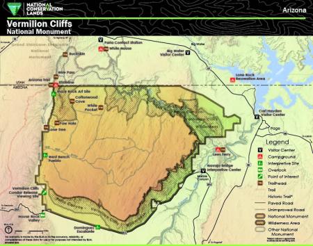
Vermilion Cliffs National Monument encompasses a dramatic landscape of sandstone cliffs, slot canyons, and remote wilderness along the Utah-Arizona border in Coconino County. The monument boundary is shown with an outline on the map. The Paria Canyon-Vermilion Cliffs Wilderness is shown with a crosshatch pattern within and adjacent to the monument boundary.
Three visitor centers and contact stations are shown on the map. The Paria Contact Station is located in the northern portion of the monument near the Utah border and serves as the main contact point for Paria Canyon permits and information. The Big Water Visitor Center is located north of the monument in Big Water, Utah, near Lake Powell. The Carl Hayden Visitor Center is located at Glen Canyon Dam near Page, Arizona. The Navajo Bridge Interpretive Center is located at Marble Canyon along US Highway 89A.
Campgrounds, interpretive sites, overlooks, points of interest, and trailheads are shown on the map with distinct symbols. Named sites shown include Buckskin, Cottonwood Cove, Dominguez-Escalante Site, House Rock Valley, Lees Ferry, Lone Rock Recreation Area, Lone Tree, Maze Rock Art Site, Paw Hole, Stateline Campground, Vermilion Cliffs Condor Release Viewing Site, West Bench Pueblo, White House, and White Pocket.
Trails are shown as dashed red lines on the map. The Arizona Trail is shown entering the monument from the west near Stateline. Wire Pass is shown as a trailhead in the northwestern portion of the monument. Historic trails are shown as dashed gray lines and are in approximate locations only.
Paved roads are shown as solid dark lines and unimproved roads are shown as solid gray lines. US Highway 89 and US Highway 89A are shown as the primary access routes to the monument. State Route 98 is shown to the east near Page. House Rock Valley Road and Pine Tree Road are shown as the primary unimproved access routes within the monument. Reference directions to Flagstaff, Fredonia, Highway 89, and Kanab are shown for geographic orientation.
The Colorado River is shown along the eastern edge of the monument, flowing from Lake Powell southward through Marble Canyon. The Paria River is shown flowing through the central portion of the monument from Utah into the Colorado River. Lake Powell is shown in the northeastern corner of the map.
Grand Staircase-Escalante National Monument borders Vermilion Cliffs National Monument to the north and west in Utah. The Utah-Arizona state boundary is shown crossing through the northern portion of the map. The communities of Big Water (Utah), Marble Canyon, and Page are shown for geographic reference.
This map was produced in 2015. The map number is M14-09-01.
For questions, contact the Public Lands Information Center.
No warranty is made by the BLM as to the accuracy, reliability, or completeness of these data for use or for purposes not intended by BLM.