
Four Dances SRMA
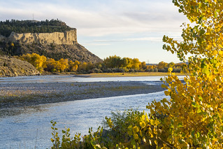
Through cooperative efforts, landowners, the Yellowstone River Parks Association, and the Bureau of Land Management (BLM) preserved 765 acres of undeveloped open space in Billings. These public lands mostly consist of native sagebrush/grassland, ponderosa pine in the rocky outcrop areas near the river cliffs, and cottonwood riparian. Four Dances is designated a special recreation management area and an area of critical environmental concern. The BLM's objective for the site is to protect the open space and natural and cultural resources, while providing dispersed public recreation in Billings.
This area is located on a plateau 2 miles east of downtown Billings and is bordered on the east side by Coburn Road. The plateau is edged with cliffs that drop 200-500 feet to the river. The west boundary is the Yellowstone River. Activities include wildlife watching, hiking, nature photography, and environmental education. This area is for nonmotorized day use only. For protection of the area's values and public safety, the area is closed to horseback riding, use of fireworks, hang gliding, rock climbing, paintball activities, the discharging of firearms, and exercising pets off leash.

Flickr Album
Phone
Geographic Coordinates
45.7766, -108.467
Directions
This area is on a plateau located two miles east of downtown Billings and is bordered on the east side by Coburn Road. This plateau is edged with cliffs that drop 200-500 feet to the river. The west boundary is the Yellowstone River.
Stay Limit
Open year-round, day use only.