
In addition to William Clark’s signature, Pompeys Pillar is marked with over 5,000 other etchings and drawings of a host of characters from the pioneer past, including Euromerican fur trappers, Yellowstone River steamboat men, frontier army troops, railroad workers, missionaries, and early settlers. In a very real sense, Pompeys Pillar’s sandstone facets hold a vivid history of the unfolding West.
Francois Antoine Larocque
In 1805 Francois Antoine Larocque became the first white man to document the rock known today as Pompeys Pillar. Larocque was a French Canadian fur trapper and explorer who worked for the British Northwest Company. In 1804, the Northwest Company ordered Larocque to meet with Lewis and Clark at the Mandan villages to inquire about fur resources and ask to join their expedition. After being denied permission, Larocque was sent by the Northwest Company to contact Crow Indians on the Yellowstone River in search of fur resources. Larocque traveled west with various Crow bands to their homelands and sighted the Yellowstone River ten months before Clark’s party. On September 15,1805, Larocque arrived at Pompeys Pillar and described a "whiteish perpendicular rock on which was sketched with red soil a battle between three people on horseback and three others on foot." He also described seeing “buffalo and deer in great quantity” in the vicinity of the Pillar. - The Journal of Francis Antoine Larocque, pg. 22
Manual Lisa
In November 1807 St. Louis entrepreneur Manuel Lisa established a trading post, Fort Ramon, 27 miles east of Pompey's Pillar at the mouth of the Big Horn River. Lisa was an agent for the Missouri Fur Company. He, along with Pierre and Auguste Chouteau, William Clark, and Andrew Henry, formed the company to establish a fur trade network with the Crow Indians on the Yellowstone River. The company abandoned the post in 1811 because of deteriorating relations with the Crow Indians. Manual Lisa likely visited Pompeys Pillar but did not record it.
James P Beckworth
James Pierson Beckwourth was an African American mountain man, fur trader, and explorer who visited the Pillar between 1832-1834. As a fur trapper, he lived with the Crow Tribe for years. “As soon as the Indians had finished their trading, I directed them to move to the Yellow Stone, as far up as “Pompeys Tower”, telling them that I would join them in four nights. Then, as soon as I could get ready, I loaded twelve pack horses with goods for retail, and, taking two Canadians with me, I went on and joined the village at the appointed place.” - The Life and Adventures of James P. Beckworth, pg. 227
Father De Smet
Father Pierre-Jean De Smet was a Flemish Catholic priest and member of the Society of Jesus (Jesuits). He is known primarily for his widespread missionary work in the mid-19th century among American Indians. De Smet may have visited Pompeys Pillar when he travelled to meet a Crow camp between Billings and the Bighorn River in 1840. However, De Smet never specifically mentions Pompeys Pillar by name in his writings.
Chief Plenty Coups
In the spring of 1859, Chief Plenty Coups’ village was near “The Mountain Loins Lodge”. Chief Plenty Coups is known as the last chief of the Crows who allied the tribe with the US government. “One night in the early spring of that year, when our village was near The-mountain-lions-lodge [Pompeys Pillar], a young warrior named Bear-inthewater had a dream. In it he saw a band of Flatheads far to the westward.” - Plenty Coups: Chief of the Crows, pg. 85
Pretty Shield
In 1864, when Pretty Shield was 8 years old, she camped in a tepee village at Pompeys Pillar.
Pretty Shield was a medicine woman of the Crow Tribe. Her biography, perhaps the first record of female Native American life, was written by Frank B. Linderman, who interviewed her using an interpreter and sign language.
MILITARY EXPEDITIONS, SURVEYORS, AND STEAMBOATS
Between 1853 and 1873 several military expeditions explored and mapped the area around Pompey's Pillar in search of a route for a transcontinental railroad.
Lieutenant Henry Maynadier
In 1860 Lieutenant Henry Maynadier, along with scout Jim Bridger, visited Pompeys Pillar while mapping the Yellowstone River. Maynadier was sent by Captain William Raynolds as part of a military expedition organized to identify agricultural and mineral resources of the area and determine whether the Yellowstone was accessible for steamboat traffic. In July 1860, Maynadier observed a solar eclipse from the summit of Pompey's Pillar and noted American Indian pictographs on the feature.
James Stuart Mining Party
On May 3, 1863, James Stuart and his gold prospecting mining party visited Pompeys Pillar and noticed Clark's inscription and the names of two of his men. Stuart was the first person to record observation of Clark’s signature on Pompeys Pillar. Stewart also documented seeing the names of two other members of the Lewis and Clark Expedition - Sgt. York and Pvt. Shannon - carved in the rock near Clark's signature. No trace of those signatures remains. Stuart also wrote of seeing large herds of buffalo from the top of the Pillar.
Railroad Survey
In early spring of 1872, the Northern Pacific Railroad initiated action to carry on their surveys in an intensified manner and called upon the government to provide protection. They planned to run rail lines over a vast region going from the base of the Rocky Mountains to the Missouri River at Bismarck. This route clearly was passing through hostile Sioux Indian land. Two survey parties were established, one starting out from Bismarck, and one from the place on the Yellowstone River that they abandoned the previous year. They also planned to complete a survey of the valley from there to the mouth of the Powder River.
Hayden Survey Team
On August 17th, 1872, Colonel Hayden and his team of survey engineers (headed east) spotted Pompey’s Pillar across the river but did not cross the river to approach the butte. At this point, they turned north to the Musselshell River.
Thomas Leforge
Thomas Leforge was an American writer who was the author of Memoirs of a White Crow Indian. His highly detailed account of living among the Crow Indian Tribe during the mid-to-late 19th century includes descriptions of meeting a Crow camp and crossing the river ford at Pompeys Pillar in the early 1870s.
The Yellowstone Expedition
On the morning of August 15th, 1873, the Yellowstone Expedition camped at Pompeys Pillar. The Yellowstone Expedition was a military expedition escorting a survey party investigating a route for the second transcontinental railroad, General DS Stanley commanded the survey support party consisting of 1,500 men plus an abundance of ammunition and supplies. General Custer, who commanded 450 men of the 7th Cavalry, was part of the force. The group also consisted of about 375 civilian surveyors and several European “adventurers”. A continuous survey line from the Great Lakes to the Puget Sound for the Northern Pacific Railroad was completed. During the 1873 expedition, William Pywell was the first person to photograph Pompeys Pillar.
On the morning March 15, 1873, while the soldiers bathed in the Yellowstone River, nine Lakota and Cheyenne snipers fired at the group from under cover of Pompey's Pillar. As the men fled for cover, one soldier was wounded. The following day, the expedition broke camp and headed north into the Musselshell River country before returning to the Dakotas.
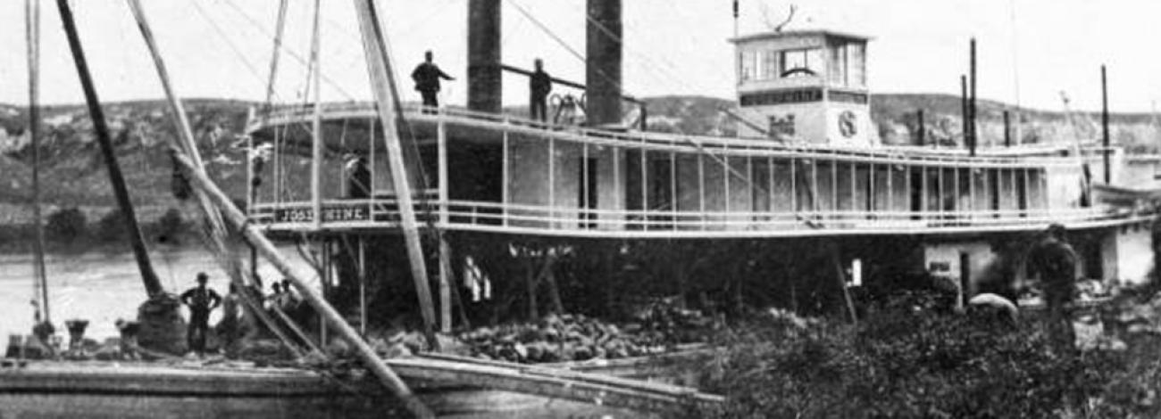
Steamboat Josephine
On June 3, 1875, the steamboat Josephine reached Pompey's Pillar. The Josephine carried an expedition up the Yellowstone River led by Captain Grant Marsh. The expedition included a crew of 37 men, several Smithsonian professors, and 107 soldiers from Fort Abraham Lincoln in Dakota Territory. Marsh later wrote that he did not expect to reach that far upriver. Passengers spent a day exploring the Pillar, and some of them carved their names into the rock. There was a stonecutter among the soldiers and General Forsyth ordered that the names be carved more deeply. There is a possibility that Clark’s inscription may have been cut more deeply by a member of the Josephine crew.
Captain Marsh carved the name of the ship and the date on the rock and became the first person to raise an American flag on the summit of Pompeys Pillar. Marsh also recorded in his log that he saw Clark’s signature. In 1875, according to a biographer of steamboat captain Grant Marsh, Marsh found Clark's inscription to be "as clearly defined as when chiseled there by the illustrious explorer, sixty-nine years before." Olson's 2001 archaeological report said a 1940 article in the Billings Gazette, the date of which was given only as 1940, "asserted that soldiers from Ft. Buford could have recarved the signature in 1875, before Marsh saw it."
Montana Column
On April 17, 1876, a force of about 450 cavalrymen from the Montana Column, under Colonel John Gibbon, camped near Pompeys Pillar. The Montana column had been sent through the Yellowstone Valley on foot, along with a group of Crow scouts led by Lt. James H. Bradley, to prevent the escape of fleeing Sioux and Cheyenne prior to the Battle at Little Bighorn. Some of the men inscribed their names in the rock, and several men noted Clark's signature in their journals. Lt. James H. Bradley, Gibbon's commander of scouts, noted that Capt. William Clark's signature "still appears as distinctly as when graven there 70 years ago. But a cavalry vandal today disfigured the inscription by carving his own name over the letter 'k.' For that he deserves to be pilloried."
General Howard
In September of 1877 General Howard and a group of wounded soldiers stopped at Pompeys Pillar. The group was part of the U.S. Military pursuit of the Nez Perce Indians who had fled their homeland in the Pacific Northwest to Canada to escape capture. The soldiers had been wounded at the battle of Canyon Creek under the command of Colonel Sturgis. Howard brought supplies to the wounded troops at the Canyon Creek battlefield and took them on a detour 40 miles down the Yellowstone River. The group stayed at the Pillar for two days. There, they secured a wide-bottomed mackinaw riverboat, used to haul freight, to take the wounded soldiers to a hospital on the Tongue River. Howard headed north on the prairie to meet with Sturgis’ camp on the Musselshell River.
Steamboat Yellowstone
In May 1878, the steamboat Yellowstone reached Pompeys Pillar. The Yellowstone belonged to Bozeman physician Achilles Lamme and rancher Nelson Story's Yellowstone Transportation Company. The steamboat, commanded by John Calhoun Bryson, carried sixty tons of freight destined for Bozeman. Pompey's Pillar was as far as the vessel could reach and the crew unloaded the cargo there for pickup.
Two-Leggings
In 1879 Two-Leggings, a Crow warrior and chief, camped near the Mountain Lions Lodge. Two-Leggings noted that at this time, about 3 years after the Battle of the Little Bighorn, there were fewer buffalo on the plains and his group had to move frequently to feed themselves and obtain hides for their tipis.
H.D. Johnson
On March 28, 1879, white ranchers H.D. Johnson and Sterns were attacked by Sioux Indians at their cabin near Pompeys Pillar. Johnson was shot in the head and Sterns escaped. Johnson’s grave is believed to be near southern side of the Pillar.
E.S. Topping
In 1883 E.S. Topping published his book "The Chronicles of the Yellowstone." The book described that the signature and date engraved by Clark "by the vicissitudes of weather and vandalism have become nearly obliterated." Topping gave no indication in the book when he last saw Pompeys Pillar.
Northern Pacific Railroad
In 1882, the same year the Northern Pacific Railroad was completed, the Northern Pacific Railway Company acquired a 400 foot right-of-way through the area about a half mile south of Pompeys Pillar. The railroad provided transportation through the Yellowstone River Valley, and Pompeys Pillar was plainly seen from passing trains. Passengers stopping at the railroad station a half mile south of the Pillar routinely visited the site to view Clark’s inscription.
In 1882, Col. J.B. Clough, an engineer with the Northern Pacific Railway, had a heavy iron grate made and sunk firmly into the rock over the signature to protect it from further damage. An article in the Great Falls Tribune on Dec. 12, 1954, reported that when the grate was placed over the site, "the signature was engraved a bit deeper in the rock to offset the erosion that occurred." No documentation was given for that claim.
In "The Trail of Lewis and Clark," published in 1904, author Olin D. Wheeler said the railroad's protection was needed because the name "is now hard to decipher, for the irrepressible fool has been there, and has scratched and cut his names all around it, and even over some of the letters between the lines."
In 1926, at the instigation of the local Shining Mountain Chapter of the Daughters of the American Revolution (DAR) group, the railroad authorized the Billings Marble and Granite Works to cut the letter deeper into the stone. In 1928 the Billings chapter of the DAR erected a bronze plaque commemorating Lewis and Clark.
Land Cession
In 1882 and 1892, the Crow Reservation was reduced by an additional three million acres. The tribe ceded territory east and south of the Yellowstone River in response to mounting pressure from local farmers and ranchers in the Yellowstone Valley, mining interests in the Beartooth Mountains, and the Northern Pacific Railroad.
Dawes Act
In 1887 The Dawes Act (sometimes called the Dawes Severalty Act or General Allotment Act), passed under President Grover Cleveland, allowing the federal government to break up tribal lands. The federal government aimed to assimilate American Indians into mainstream US society by encouraging them towards farming and agriculture, which meant dividing tribal lands into individual plots. Only the American Indians who accepted the division of tribal lands were allowed to become US citizens.
Pompeys Pillar Ceded
In 1899, the Crow Tribe ceded another 1,150,000 acres south of the Yellowstone River (including the site of Pompeys Pillar) to the federal government for $1.15 million. The agreement was not ratified by Congress until 1904 and stipulated that if Crow tribal members claimed and farmed an allotment they could stay in the area. The ceded area, including Pompeys Pillar, was not opened to non-Indian settlement until 1911.
HOMESTEAD ERA
By the late 19th century, the agricultural potential of the rich Yellowstone River valley had become apparent to settlers, land speculators and Congress. Although much of the Yellowstone Valley, including Pompeys Pillar, had been within the boundaries of the Crow Reservation, legislation and local pressure pushed the Crow tribe to cede the Yellowstone Valley in 1882, 1892, and 1899. The ceded area, including Pompeys Pillar, was not opened to non-Indian settlement until 1911. The lands were settled shortly after the turn of the 20th century when the Huntley Irrigation District was established.
Macer Family
Just prior to the Crow Reservation cession of 1904, Edward K. and Margaret Macer moved to the area of Pompeys Pillar before it was removed from the reservation.
The area around the Pillar was allotted to the Macers who began farming in 1904. In 1906 the Macers’ four children, Beatrice, George, Henry, and James, were each entitled to and given an adjacent land allotment. In 1918 Beatrice Mabel Macer filed for and was issued an Indian Allotment Treaty Patent, officially making Pompeys Pillar private property. Patents were also issued to George, James, and Henry Macer. In 1920 Henry acquired all of Mabel’s interests for the property. Henry became deep in debt and eventually lost his land to the holder of his mortgage. In 1924, Henry sold Pompeys Pillar and the surrounding land to Martin Tschida, a Yellowstone Valley Farmer.
The Huntley Project
When Congress passed the National Reclamation Act of June 17, 1902, the measure set in motion the dramatic transformation of arid sections of the American West to "reclaim" land for productive agricultural use. President Theodore Roosevelt, who signed the bill into law, believed that reclaiming arid lands would promote the agrarian ideals of Thomas Jefferson. The legislation authorized the Secretary of the Interior to designate irrigation sites and to establish a reclamation fund from the sale of public lands to finance the projects. The Act required that water users repay construction costs from which they received benefits. In the jargon of that day, irrigation projects were known as "reclamation" projects. The concept was that irrigation would "reclaim" arid lands for human use.
The potential of the Huntley Project area was recognized by Fredrick Billings who started a conversation with government officials. In 1902 the US government started construction on the Huntley Irrigation Project, an area about 27 miles long and 4 miles wide that included the site of Pompeys Pillar. The area was planned out on paper noting the placement of towns, schools, and irrigation routs.
In 1907 the gates of the Huntley Project Irrigation canal were opened. Farm units were 40 acres each. A drawing was set up on June 26, 1907 for the 582 farm units in the Huntley Irrigation Project. The Huntley Irrigation Project became known as the Huntley Project consisting of several small towns. A drought around 1910 forced many settlers to abandon their claims. Other families stayed and lived out their pioneer dreams. Many of the pioneer families have relatives that have lived in the same area for over 100 years.
Bundy Bridge
In 1915, The Bundy Bridge was built across the Yellowstone River upriver from the Pillar. The bridge was the first riveted through truss constructed across the Yellowstone River in Montana. It was also significant because it opened the territory north of the Yellowstone River in the vicinity of Pompeys Pillar to ranching and homesteading by allowing access to the Northern Pacific Railroad station at Pompeys Pillar. It was also one of the last bridge-company designed and constructed bridges built in Montana without the direct involvement of the Montana Highway Commission.
Martin Tschida
In 1924, Martin Tschida, a Yellowstone Valley Farmer, purchased Pompeys Pillar and the surrounding land from Henry Macer.
EARLY TOURISM AND COMMEMORATION
Beginning in the early 1900s, Pompeys Pillar became the site of several celebrations, commemorations, and official designations.
Picnic at the Pillar
A large 4th of July celebration was held at Pompeys Pillar in 1922. The event consisted of food, foot races, and ball games and drew 1400 cars.
Daughters of the American Revolution
In 1926, at the instigation of the local Billings Shining Mountain Chapter of the Daughters of the American Revolution (DAR) group, the railroad authorized the Billings Marble and Granite Works to cut the letter deeper into the rock. In 1928 the DAR group erected a bronze plaque commemorating Lewis and Clark. A plaque unveiling ceremony was held on May 24, 1926.
Masons
On June 20, 1938, the Billings Masons Lodge placed a second plaque near Clark’s signature honoring Captains Meriwether Lewis and William Clark. Lewis and Clark were both pioneer Masons – members of the St Louis Lodge Number 1 in Missouri. 1000 Masons attended the ceremony, which was the first meeting of its kind ever held by a Masonic Body in Montana. This event drew the largest documented group in recorded history since the Montana Column in 1876.
Foote Family
Don and Stella Foote began leasing the land surrounding Pompeys Pillar from Martin Tschida in 1953. In 1954 The Great Falls Tribune reported on the Footes' plans to preserve the signature and make the pillar into a tourist attraction. The Tribune reported: "As the Footes develop the site, they propose to remove the iron grille, carve the name deeper again, then to place a shatter-proof glass over the signature in a bronze frame securely anchored to the rock." In 1955, the Footes of Billings purchased the property containing Pompeys Pillar and 105 surrounding acres.
The Footes developed the site as a privately operated historical area then called "Pompeys Pillar Monument Park." They had Clark’s signature encased in a bronze casement sunk into the rock, with inch-thick shatterproof glass protecting the carving. Stella Foote said the signature was still legible when she and her late husband replaced the grille with the bronze and glass casement. According to a 2006 Billings Gazette article, at first Stella said she could not recall whether she and her husband had the signature restored, but then she said they probably did, adding, "but I'm sure we had somebody good" who would respect the historical integrity of the artifact.
The Footes also graded trails up the north side of the Pillar, installed steps and railings, added interpretive markers, built a road from the highway to the riverbank and around the base of the pillar, cleared an unpaved parking area at the base of the Pillar, cleared paths through the cottonwood trees lining the riverbank, and installed picnicking facilities. They also moved three old buildings to the area including a turn-of-the century country store from Nibbe, Montana, a log structure from the Billings suburb of Lockwood, and a homesteader's cabin from Livingston. These buildings, plus a fourth structure intended for a livery stable and then used for a ticket booth, and a mobile home used by the owners, were all located in a wooded area just east of the pillar. The buildings were non-historic and did not contribute to the national significance of the site.
The Footes displayed a number of miscellaneous objects associated with western history, though not necessarily with Pompeys Pillar, around the base of the rock formation, including a number of old wagons which lined the road south of the pillar, a display of petrified wood, a case of American Indian artifacts and a dugout canoe built by a local group. After the original purchase of 105 acres, the Foote family purchased approximately 80 more acres of adjacent property. The adjacent property was used for farming and cattle raising and managed by a tenant whose house and farm buildings were located to the south, nearer route 312.
On July 26, 1956, the Footes held a 150th Anniversary Celebration of Clark’s visit to the Pillar.
National Historic Landmark
On June 23, 1965, Pompeys Pillar was a designated a National Historic Landmark, primarily because of the significance of William Clark’s signature panel. The boundary includes approximately 6 acres above the 2,890-foot contour level. A National Historic Landmark plaque was presented and mounted on a large rock at the base of the pillar. On July 10, 1966, a ceremony was held dedicating Pompeys Pillar as a National Historic Landmark. William Clark Adrion, descendant of Captain William Clark, Montana Governor Tim Babcock, Crow dancers, NPS representatives, and 3000 visitors attended. A replica canoe floated down the Yellowstone River.
Plaques
On June 28, 1968, the Footes moved the DAR plaque to the rock face near Clark’s signature.
On November 9, 1968, after Don Foote’s death, the Foote family placed a third plaque near Clark’s signature, commemorating the efforts of Don Foote in the preservation of Pompeys Pillar.
National Register of Historic Places
In 1983, Pompeys Pillar National Historic Landmark (6 acres) was listed on the National Register of Historic Places (NRHP) primarily because of its association and significance to cultural practices and beliefs rooted in the history of multiple American Indian tribes, and its important to maintaining the continuity of traditional beliefs and practices.
Lewis and Clark National Historic Trail
On August 10, 1985, Pompeys Pillar was designated as part of the Lewis and Clark National Historic Trail. The Trail, established in 1978, follows the historic outbound and inbound routes of the Lewis and Clark Expedition plus the preparatory section from Pennsylvania to Wood River, Illinois.
Closure and Public Endorsement
After the 1989 tourist season, rising insurance costs forced the Footes to close the area. In December, a variety of local elected officials, organizations, and community groups including the Foote family and the Pompeys Pillar Preservation Committee worked to have the land around Pompeys Pillar National Historic Landmark designated as public lands. The Pompeys Pillar Preservation Committee, A dedicated group of volunteers, eventually became the Pompeys Pillar Historical Association (PPHA).
BLM Acquisition and Management
On November 22, 1991, the BLM purchased the site of Pompeys Pillar and surrounding land for one million dollars. The purchase also included original J. K. Ralston paintings, other artwork, and a Lewis and Clark historical library. BLM prepared the area for public visitation, making improvements needed to ensure public health and safety, and constructing a modest, temporary visitor contact station and a boardwalk to access the Pillar. On July 25, 1992, Pompeys Pillar was dedicated by BLM Director Cy Jameson.
ACEC
In 1996, the BLM designated Pompeys Pillar Area of Critical Environmental Concern (432 acres) to protect cultural and historic resource values.
National Monument
On January 17, 2001, approximately 51 acres at Pompeys Pillar was designated a National Monument by executive proclamation of President Clinton (Presidential Proclamation 7396 - Appendix A). In 2006 the Pompeys Pillar National Monument Interpretive Center was completed.
National Conservation Land
In 2009, Pompeys Pillar National Monument (51 acres) became an official National Conservation Lands site when the BLM’s National Landscape Conservation System was officially ratified by the Omnibus Public Lands Management Act.
National Conservation Land
In 2009, Pompeys Pillar National Monument (51 acres) became an official National Conservation Lands site when the BLM’s National Landscape Conservation System was officially ratified by the Omnibus Public Lands Management Act.
Bicentennial
In 2006 Pompeys Pillar National Monument hosted a commemoration of the Lewis and Clark Expedition Bicentennial.