Data format: Shapefile
File or table name: pm10_non_attainment
Coordinate system: Universal Transverse Mercator
Theme keywords: pm10, particulate matter, Air Quality, ADEQ, environment
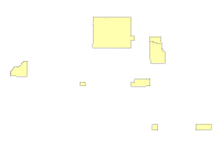
| PM10 Non-Attainment Areas | |
|
|
Data format: Shapefile File or table name: pm10_non_attainment Coordinate system: Universal Transverse Mercator Theme keywords: pm10, particulate matter, Air Quality, ADEQ, environment |
|
Abstract:
State of Arizona PM10 nonattainment boundaries. |
|
Metadata elements shown with blue text are defined in the Federal Geographic Data Committee's (FGDC) Content Standard for Digital Geospatial Metadata (CSDGM). Elements shown with green text are defined in the ESRI Profile of the CSDGM. Elements shown with a green asterisk (*) will be automatically updated by ArcCatalog. ArcCatalog adds hints indicating which FGDC elements are mandatory; these are shown with gray text.
State of Arizona PM10 nonattainment boundaries.
Provide location and attributes of features of interest to ADEQ
publication date
The Arizona Department of Environmental Quality has compiled this data as a service to our customers using information from various sources. ADEQ cannot ensure that the information is accurate, current or complete. Neither the information presented nor maps derived from them are official documents.


All data are provided "as is" and may contain errors. The data are for reference and illustration purposes only and are not suitable for site-specific decision making. Information found here should not be used for making financial or any other commitments. Conclusions drawn from such information are the responsibility of the user.

ADEQ assumes no responsibility for errors arising from misuse of the data or maps derived from the data. ADEQ disclaims any liability for injury, damage or loss that might result from the use of this information. In no event shall ADEQ become liable to users of these data and maps, or any other party, arising from the use or modification of the data.
1110 W. Washington Street
Metadata imported.
Metadata imported.
Dataset moved.
Dataset copied.
Internal feature number.
ESRI
Feature geometry.
ESRI
Area of feature in internal units squared.
ESRI
Perimeter of feature in internal units.
ESRI
1110 W Washington Street
1110 W. Washington St.