Bighorn Sheep Habitat

Data format: Shapefile

File or table name: bhshab

Coordinate system: Universal Transverse Mercator

Theme keywords: Bighorn Sheep, Habitat, Wildlife, Range
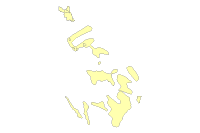
Abstract: This theme shows the geographic boundaries of Big Horn Sheep habitat in Arizona.

FGDC and ESRI Metadata:

Metadata elements shown with blue text are defined in the Federal Geographic Data Committee's (FGDC) Content Standard for Digital Geospatial Metadata (CSDGM). Elements shown with green text are defined in the ESRI Profile of the CSDGM. Elements shown with a green asterisk (*) will be automatically updated by ArcCatalog. ArcCatalog adds hints indicating which FGDC elements are mandatory; these are shown with gray text.

Identification Information:


Citation:
Citation information:
Originators: BLM-PHOENIX FIELD OFFICE


Title:
Bighorn Sheep Habitat
*File or table name: bhshab


Edition: Not Applicable
*Geospatial data presentation form: vector digital data


Series information:
Series name: Arizona BLM
Issue identification: None

Publication information:
Publication place: Phoenix, AZ
Publisher: BLM


Description:
Abstract:
This theme shows the geographic boundaries of Big

Horn Sheep habitat in Arizona.

Purpose:
For regional analysis and display at 1:100,000.

This data set was prepared/acquired for use in the PFO resource

management planning process.

*Language of dataset: en


Time period of content:
Time period information:
Single date/time:
Calendar date: 19990722

Status:
Progress: Complete
Maintenance and update frequency: As needed

Spatial domain:
Bounding coordinates:
*West bounding coordinate: -114.002477
*East bounding coordinate: -112.071450
*North bounding coordinate: 34.527149
*South bounding coordinate: 32.192339

Local bounding coordinates:
*Left bounding coordinate: 224301.471505
*Right bounding coordinate: 399037.433183
*Top bounding coordinate: 3821157.191997
*Bottom bounding coordinate: 3565505.784371

Keywords:
Theme:
Theme keywords: Bighorn Sheep, Habitat, Wildlife, Range
Theme keyword thesaurus: None

Place:
Place keywords: Phoenix Field Office, State of Arizona
Place keyword thesaurus: None

Access constraints: Discretionary, contains no sensitive information - generally considered releasable.
Use constraints:
This data should never be used at a scale larger than 1:100,000.

The data and corresponding attributes are only as accurate as the source

maps from which they were obtained, and may vary depending upon the date

and method of acquisition.


This data is suitable for regional planning, management decision support

at intermediate scales, i.e. 1:100,000 or smaller, and cartographic

purposes.  The data is not suitable for the purposes of navigation.

This data is not suitable for analysis at scales larger than 1:100,000.


If the Receiving Agency (RA) has modified the data in any way, they are

obligated to describe the types of modifications they have performed

on hardcopy maps utilizing the data.  RA specifically agrees not to

misrepresent PFO data sets nor to imply that any changes made were

approved by BLM.


No warranty is made by the BLM for use of the data for purposes

not intended by BLM.  This information may be updated without notification.

Point of contact:
Contact information:
Contact person primary:
Contact person: Chris Horyza
Contact organization: BLM Phoenix Field Office
Contact position: GIS and Planning Specialist


Contact address:
Address type: mailing and physical address
Address:
21605 N 7th Ave
City: Phoenix
State or province: AZ
Postal code: 85027
Country: USA

Contact voice telephone: (623) 580-5500
Contact facsimile telephone:


Contact electronic mail address: Chris_Horyza@blm.gov


Security information:
Security classification system: None
Security classification: Unclassified
Security handling description: None

*Native dataset format: Shapefile
*Native data set environment:
Microsoft Windows XP Version 5.1 (Build 2600) Service Pack 3; ESRI ArcCatalog 9.3.1.1850


Back to Top
Data Quality Information:


Attribute accuracy:
Attribute accuracy report:
Feature attributes were taken from source material.  Assignments

are believed to be representative of the source document.

Attributes accuracy is tested by manual comparison of the source

with the hard copy printouts.

Logical consistency report:
Polygons were checked against original manuscripts for consistency.

This theme was built with polygon topology.

Completeness report:
This layer contains data for the AZ BLM.

Positional accuracy:
Horizontal positional accuracy:
Horizontal positional accuracy report:
Overall horizontal accuracy for this data is not greater

than national mapping accuracy standards (NMAS) for USGS source maps.

Snapping and coordinate shift tolerances were maintained at 0.01

meters or less throughout editing.  Horizontal positional accuracy for

the digital data set was tested by visual comparison of the source data

with the hard copy.

Lineage:
Source information:
Source citation:
Citation information:
Originators: Not Applicable


Title:
Not Applicable


Publication date:
Geospatial data presentation form: Map


Series information:
Series name: None
Issue identification: None

Publication information:
Publication place: Not Applicable
Publisher: Not Applicable

Source citation abbreviation:
None

Source time period of content:
Time period information:
Single date/time:


Process step:
Process description:
Digitized using USGS 7.5 minute quad as source maps

on a digitizing table to capture the digital data.

BLM contractors or GIS staff digitized some of the lines from the

map overlays or conducted "heads up" digitizing using ARC/INFO

ARCEDIT module.  Heads up digitizing involved digitizing lines on

the screen using scanned aerial photos, satellite imagery, or

digital raster graphic (DRG) files as a backdrop.

Process date: Unknown


Process step:
Process description:
First draft of metadata created using

FGDCMETA.AML ver. 1.2 05/14/98 on ARC/INFO data set

Process date: 20011113


Process step:
Process description:
Metadata imported.

Source used citation abbreviation:
C:\DOCUME~1\sgrant\LOCALS~1\Temp\xml2A.tmp


Process step:
Process description:
Dataset copied.

Source used citation abbreviation:
r:\projects\sdnm_rmp\blm\phxso_sdnm_rmps\gis\biology\bhshab_p


Process step:
Process description:
Dataset moved.

Process date: 20100608
Process time: 15054000


Source used citation abbreviation:
R:\projects\LS_SDNM_DRMP_DEIS\GIS_DATA_To_Public\Biology\bhshab


Back to Top
Spatial Data Organization Information:


*Direct spatial reference method: Vector


Point and vector object information:
SDTS terms description:
*Name: bhshab
*SDTS point and vector object type: G-polygon
*Point and vector object count: 18

SDTS terms description:
*Name: label
*SDTS point and vector object type: Label point
*Point and vector object count: 18

SDTS terms description:
*Name: polygon
*SDTS point and vector object type: GT-polygon composed of chains
*Point and vector object count: 18

SDTS terms description:
*Name: tic
*SDTS point and vector object type: Point
*Point and vector object count: 36

ESRI terms description:
*Name: bhshab
*ESRI feature type: Simple
*ESRI feature geometry: Polygon
*ESRI topology: FALSE
*ESRI feature count: 18
*Spatial index: FALSE
*Linear referencing: FALSE


ESRI terms description:
*Name: label
*ESRI feature type: Simple
*ESRI feature geometry: Label
*ESRI topology: FALSE
*ESRI feature count: 18
*Spatial index: FALSE
*Linear referencing: FALSE


ESRI terms description:
*Name: polygon
*ESRI feature type: Simple
*ESRI feature geometry: Polygon
*ESRI topology: TRUE
*ESRI feature count: 18
*Spatial index: FALSE
*Linear referencing: FALSE


ESRI terms description:
*Name: tic
*ESRI feature type: Simple
*ESRI feature geometry: Tic
*ESRI topology: FALSE
*ESRI feature count: 36
*Spatial index: FALSE
*Linear referencing: FALSE


Back to Top
Spatial Reference Information:


Horizontal coordinate system definition:
Coordinate system name:
*Projected coordinate system name: NAD_1983_UTM_Zone_12N
*Geographic coordinate system name: GCS_North_American_1983

Planar:
Grid coordinate system:
*Grid coordinate system name: Universal Transverse Mercator
Universal Transverse Mercator:
*UTM zone number: 12
Transverse mercator:
*Scale factor at central meridian: 0.999600
*Longitude of central meridian: -111.000000
*Latitude of projection origin: 0.000000
*False easting: 500000.000000
*False northing: 0.000000

Planar coordinate information:
*Planar coordinate encoding method: coordinate pair
Coordinate representation:
*Abscissa resolution: 0.000000
*Ordinate resolution: 0.000000
*Planar distance units: meters

Geodetic model:
*Horizontal datum name: North American Datum of 1983
*Ellipsoid name: Geodetic Reference System 80
*Semi-major axis: 6378137.000000
*Denominator of flattening ratio: 298.257222

Back to Top
Entity and Attribute Information:


Detailed description:
*Name: bhshab


Entity type:
*Entity type label: bhshab
*Entity type type: Feature Class
*Entity type count: 18

Attribute:
*Attribute label: FID
*Attribute alias: FID
*Attribute definition:
Internal feature number.
*Attribute definition source:
ESRI

*Attribute type: OID
*Attribute width: 4
*Attribute precision: 0
*Attribute scale: 0


Attribute domain values:
*Unrepresentable domain:
Sequential unique whole numbers that are automatically generated.


Attribute:
*Attribute label: Shape
*Attribute alias: Shape
*Attribute definition:
Feature geometry.
*Attribute definition source:
ESRI

*Attribute type: Geometry
*Attribute width: 0
*Attribute precision: 0
*Attribute scale: 0


Attribute domain values:
*Unrepresentable domain:
Coordinates defining the features.


Attribute:
*Attribute label: SEASON
*Attribute alias: SEASON


*Attribute type: String
*Attribute width: 6


Attribute:
*Attribute label: USE
*Attribute alias: USE


*Attribute type: String
*Attribute width: 4


Attribute:
*Attribute label: NAME
*Attribute alias: NAME


*Attribute type: String
*Attribute width: 52


Attribute:
*Attribute label: ACRES
*Attribute alias: ACRES


*Attribute type: Number
*Attribute width: 16


Attribute:
*Attribute label: CAT
*Attribute alias: CAT


*Attribute type: Float
*Attribute width: 13


Detailed description:
*Name: bhshab_p.pat


Entity type:
*Entity type label: bhshab_p.pat
*Entity type type: Feature Class
*Entity type count: 18

Attribute:
*Attribute label: FID
*Attribute alias: FID
*Attribute definition:
Internal feature number.
*Attribute definition source:
ESRI

*Attribute type: OID
*Attribute width: 4
*Attribute precision: 0
*Attribute scale: 0


Attribute domain values:
*Unrepresentable domain:
Sequential unique whole numbers that are automatically generated.


Attribute:
*Attribute label: Shape
*Attribute alias: Shape
*Attribute definition:
Feature geometry.
*Attribute definition source:
ESRI

*Attribute type: Geometry
*Attribute width: 0
*Attribute precision: 0
*Attribute scale: 0


Attribute domain values:
*Unrepresentable domain:
Coordinates defining the features.


Attribute:
*Attribute label: AREA
*Attribute definition:
Area of feature in internal units squared.
*Attribute definition source:
ESRI

*Attribute type: String
*Attribute width: 6
*Attribute output width: 18


Attribute domain values:
*Unrepresentable domain:
Positive real numbers that are automatically generated.


Attribute:
*Attribute label: PERIMETER
*Attribute definition:
Perimeter of feature in internal units.
*Attribute definition source:
ESRI

*Attribute type: String
*Attribute width: 4
*Attribute output width: 18


Attribute domain values:
*Unrepresentable domain:
Positive real numbers that are automatically generated.


Attribute:
*Attribute label: BHSHAB_P#
*Attribute definition:
Internal feature number.
*Attribute definition source:
ESRI

*Attribute type: String
*Attribute width: 52
*Attribute output width: 5


Attribute domain values:
*Unrepresentable domain:
Sequential unique whole numbers that are automatically generated.


Attribute:
*Attribute label: BHSHAB_P-ID
*Attribute definition:
User-defined feature number.
*Attribute definition source:
ESRI

*Attribute type: Number
*Attribute width: 16
*Attribute output width: 5
*Attribute number of decimals: 2


Attribute:
*Attribute label: SEASON


*Attribute type: Float
*Attribute width: 13
*Attribute output width: 6
*Attribute number of decimals: 11


Attribute:
*Attribute label: USE


*Attribute type: String
*Attribute width: 4
*Attribute output width: 4


Attribute:
*Attribute label: STARTCLOSE


*Attribute type: Date
*Attribute width: 8
*Attribute output width: 8


Attribute:
*Attribute label: ENDCLOSE


*Attribute type: Date
*Attribute width: 8
*Attribute output width: 8


Attribute:
*Attribute label: NAME


*Attribute type: String
*Attribute width: 52
*Attribute output width: 52


Attribute:
*Attribute label: ACRES


*Attribute type: Number
*Attribute width: 16
*Attribute output width: 16
*Attribute number of decimals: 2


Attribute:
*Attribute label: CLOSURE


*Attribute type: String
*Attribute width: 17
*Attribute output width: 17


Attribute:
*Attribute label: HECTARES


*Attribute type: Float
*Attribute width: 19
*Attribute output width: 16
*Attribute number of decimals: 11


Attribute:
*Attribute label: BSHAB


*Attribute type: String
*Attribute width: 1
*Attribute output width: 1


Overview description:
Entity and attribute overview:
Attribute items are in typical ARC/INFO

point, line, polygon format.


>

>BHSHAB_P.PAT:

>

>COLUMN   ITEM NAME        WIDTH OUTPUT  TYPE N.DEC  ALTERNATE NAME

>    1  AREA                   8    18     F      5

>    9  PERIMETER              8    18     F      5

>   17  BHSHAB_P#              4     5     B      -

>   21  BHSHAB_P-ID            4     5     B      -

>   25  LABEL                 52    52     C      -

>   77  SEASON                 6     6     C      -

>   83  USE                    4     4     C      -

>   87  CLOSURE               17    17     C      -

>  104  ACRES                 16    16     N      2

>  120  HECTARES               8    16     F      3

>

>

>BHSHAB_P.AAT:

>

>COLUMN   ITEM NAME        WIDTH OUTPUT  TYPE N.DEC  ALTERNATE NAME

>    1  FNODE#                 4     5     B      -

>    5  TNODE#                 4     5     B      -

>    9  LPOLY#                 4     5     B      -

>   13  RPOLY#                 4     5     B      -

>   17  LENGTH                 8    18     F      5

>   25  BHSHAB_P#              4     5     B      -

>   29  BHSHAB_P-ID            4     5     B      -

>   33  DATADEF               30    30     C      -

>   63  LABEL                 52    52     C      -

>

>

Attributes requiring additional explanation are:

Entity and attribute detail citation:
Not available

Back to Top
Distribution Information:


Distributor:
Contact information:
Contact organization primary:
Contact organization: BLM Phoenix Field Office
Contact position: GIS Specialist


Contact address:
Address type: mailing and physical address
Address:
21605 N 7th Ave
City: Phoenix
State or province: AZ
Postal code: 85027
Country: USA

Contact voice telephone: (623) 580-5500


Contact electronic mail address: Chris_Horyza@blm.gov


Contact instructions:


Resource description: Downloadable Data


Distribution liability:
No warranty is made by the Bureau of Land Management as to the

accuracy, reliability, or completeness of these data for individual

use or aggregate use with other data.

Standard order process:
Digital form:
Digital transfer information:
Format name: ARCE (ARC/INFO export)
Format version number: 7.1.2
Format specification:
ESRI
*Transfer size: 0.027
*Dataset size: 0.027

Digital transfer option:
Online option:
Computer contact information:
Network address:

Ordering instructions:
phone


Technical prerequisites:
Ability to read Arc Export files.


Back to Top
Metadata Reference Information:


*Metadata date: 20110803


*Language of metadata: en


Metadata contact:
Contact information:
Contact organization primary:
Contact person: Chris Horyza
Contact organization: BLM Phoenix Field Office
Contact position: GIS and Planning Specialist


Contact address:
Address type: mailing and physical address
Address:
21605 N 7th Ave
City: Phoenix
State or province: AZ
Postal code: 85027
Country: USA

Contact voice telephone: (623) 580-5500
Contact facsimile telephone:


Contact electronic mail address: Chris_Horyza@blm.gov


*Metadata standard name: FGDC Content Standards for Digital Geospatial Metadata
*Metadata standard version: FGDC-STD-001-1998
*Metadata time convention: local time


Metadata access constraints: None
Metadata use constraints:
None


Metadata extensions:
*Online linkage: http://www.esri.com/metadata/esriprof80.html
*Profile name: ESRI Metadata Profile

Back to Top
Geoprocessing History:


Process:
*Date: 20100608
*Time: 144315
*Tool location: C:\Program Files\ArcGIS\ArcToolbox\Toolboxes\Data Management Tools.tbx\CopyFeatures
*Command issued: CopyFeatures r:\projects\ls_sdnm_drmp_deis\gis_data\biology\animals\bhshab_p\polygon R:\projects\LS_SDNM_DRMP_DEIS\GIS_DATA_To_Public\Biology\bhshab_p_polygon.shp # 0 0 0


Process:
*Date: 20100608
*Time: 144821
*Tool location: C:\Program Files\ArcGIS\ArcToolbox\Toolboxes\Data Management Tools.tbx\DeleteField
*Command issued: DeleteField bhshab AREA;PERIMETER;BHSHAB_P_;BHSHAB_P_I;STARTCLOSE;ENDCLOSE;CLOSURE;HECTARES;BSHAB bhshab


Back to Top
Binary Enclosures:


Thumbnail:
Enclosure type: Picture


Back to Top