
Pompeys Pillar has been a significant site to several American Indian Tribes of the Northern Plains from prehistory into the modern era. American Indians have visited and inhabited the site of Pompeys Pillar for over 11,000 years to hunt, live, trade, and perform rituals.
Land Acknowledgement
Pompeys Pillar is within the homeland of the Apsaalooke, or Crow people. One Crow name for the Pillar is, Iishbiiammaache, or “The Mountain Lion’s Lodge.” In addition to the Crow, Pompeys Pillar has been an important landmark to numerous other American Indian Tribes throughout history and prehistory, including members of the Shoshone, Sioux, Cheyenne, Arapaho, Blackfeet and Salish tribes.
Ethnographic and archaeological evidence indicate that the Pillar has been a place of ritual and religious activity for several American Indian tribes for over 11,000 years. Hundreds of pictographs and petroglyphs on the face of the rock reflect the importance of the monument to early peoples.
American Indian Tribes of Montana
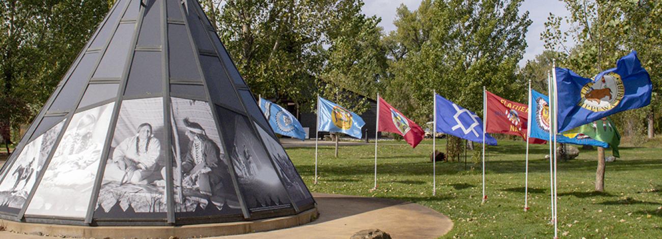
Pompeys Pillar National Monument flies and recognizes the flags of the eight federally recognized tribes of Montana:
- Assiniboine and Sioux Tribes of the Fort Peck Indian Reservation
-
Blackfeet Tribe of the Blackfeet Indian Reservation of Montana
-
Chippewa-Cree Indians of the Rocky Boy's Reservation
-
Confederated Salish and Kootenai Tribes of the Flathead Reservation
-
Crow Tribe of Montana
-
Fort Belknap Indian Community of the Fort Belknap Reservation of Montana
-
Little Shell
-
Northern Cheyenne Tribe of the Northern Cheyenne Indian Reservation
Prehistory
Pompeys Pillar lies within a prehistoric travel corridor. The rock’s premier location at a natural ford in the Yellowstone River, and its geologic distinction as the only major sandstone formation in the area, have made Pompeys Pillar a celebrated landmark and outstanding observation point for more than eleven thousand years of human occupation.
Archaeological evidence of extensive prehistoric use and past occupation of the Pillar area by American Indians has been discovered at various depths below ground. These materials appear to be the remains of hunting and living camps, probably occupied by relatively small groups of people for short periods of time. The remains of butchered bison and other animals along with mussels from the nearby Yellowstone River are scattered among flaked stone tools and debris around small surface hearths. The ancient camps were buried by slow-moving flood waters soon after abandonment, preserving organic and other materials in place, with later occupations leaving remains on the new, higher surfaces.
The Pillar was used for centuries as a favored campsite by Crows and other groups as they traveled through the area on hunting, trading, war, or other expeditions. Ethnographic and archaeological evidence suggest that the Pillar was also a place of ritual and religious activity.
Crow Ethnography
One common Crow name for the Pillar is Iishbiiammaache [“ish – bia – machya”] - variously translated as “Where the Mountain Lion Lies,” “The Mountain Lion’s Lodge,” or “Where the Mountain Lion Preys.” Other Crow names for the Pillar include Uuxhilíatte, meaning Hill near the Yellowstone River, and Iisbíiaassaao – Mountain Lion’s Home.
One Crow legend reported that Pompey's Pillar was once attached to the sandstone bluffs on the north side of the Yellowstone River. At one point, however, the rock detached itself from the cliffs and rolled across the river to its present site. Contemporary geologic studies confirm the Pillar is a detached monumental outcrop of sandstone that was separated from the sandstone bluffs on the north side of the Yellowstone River by erosion.
Rock Images
Hundreds of ancient rock images including petroglyphs and pictographs have been found and documented on Pompeys Pillar. Pictographs are images carved into rock and pictographs are images painted on rock. A range of different styles are depicted, indicating both a long time depth of usage and usage by people of different cultural traditions. The elements of rock images on Pompeys Pillar attributed to American Indians include faintly incised square-shouldered anthropomorphs (human-like form).
American Indian pictographs and petroglyphs at Pompeys Pillar have been written over by Euro-American names and dates in most cases. Extant fragments of them are decipherable, and it is likely that more exist. Most of these images are likely Crow, but other tribes are likely represented.
Early Historic Documentation
In 1805, French-Canadian fur-trader, Francois Antoine Larocque, wrote of journeying with a band of Crows through the area around Pompeys Pillar, and also noted “… a whitish perpendicular rock [Pompeys Pillar] on which was sketched with red soil a battle between three people on horseback and three others on foot.”
In 1806, William Clark of the Lewis and Clark Expedition made several entries in his journal recording seeing “signs” of the Crow, but never actually encountered them. He noted seeing a “lodge” built on an island near Pompeys Pillar, the “smoke” of the Crow Indians, and upon reaching the Pillar noted “The Indians have made 2 piles of stone on top of this Tower. The natives here ingrave (sic) on the face of the rock the figures of animals and near which I marked my name and the day and the month and year.”
American writer Thomas LeForge also documented Crow use of a ford from Pompeys Pillar north to a creek of the same name which drained south into the Yellowstone River. He also noted that the landmark was used as a rendezvous point for war parties, perhaps because of this ford.
Crow Territory and Treaties
Pompeys Pillar, or the Mountain Lion’s Lodge, is part of the traditional territory of the Crow Tribe. Pompeys Pillar was located in the center of the lands traditionally used by the Crow before the reservation period and into the turn of the 19th century. At the time of the Louisiana Purchase in 1803, there was a local abundance of buffalo around Pompeys Pillar which the Crow relied on for food, clothing, and lifestyle. The Crow tribe lived and travelled in small groups but came together for special events such as dances and large buffalo hunts.
In 1825 a number of tribes in the northern plains, Including the Crow, signed a treaty of friendship with the United States government. This was the first step in the official long-standing relationship between the US Government and the Crow tribe.
The 1851 Treaty of Fort Laramie included Pompeys Pillar in the first officially designated Crow Indian territory. This treaty between seven Plains tribes and the US Government designated territorial boundaries, allowed the US to build roads and forts through tribal land, and granted tribes annuities for fifty years (later reduced to ten years).
The 1868 Treaty of Fort Laramie established the Crow Reservation and included Pompeys Pillar within its boundaries. The Crow Reservation was significantly reduced and confined to the south side of the Yellowstone River, making Pompeys Pillar the northernmost boundary of the reservation. The treaty was a response to continued Lakota, Northern Cheyenne and Arapaho involvement on the nearby Bozeman Trail, increased demands for tribal lands, and pressure from southwestern Montana mining and ranching interests. In 1868, the US government called a gathering of the northern Great Plain tribes to Fort Laramie to end fighting and re-establish the boundaries set in 1851. The resulting treaty further reduced Indian territory, closed the Bozeman trail, and included several provisions to encourage a transition to farming and to move the tribes "closer to the white man's way of life."
Land Cession
In 1882 and 1892, the Crow Reservation was reduced by an additional three million acres. The tribe ceded territory east and south of the Yellowstone River in response to mounting pressure from local farmers and ranchers in the Yellowstone Valley, mining interests in the Beartooth Mountains, and the Northern Pacific Railroad.
The Dawes Act of 1887 (sometimes called the Dawes Severalty Act or General Allotment Act), passed under President Grover Cleveland, allowing the federal government to break up tribal lands. The federal government aimed to assimilate American Indians into mainstream US society by encouraging them towards farming and agriculture, which meant dividing tribal lands into individual plots. Only the American Indians who accepted the division of tribal lands were allowed to become US citizens.
Pompeys Pillar Ceded
In 1899, the Crow Tribe ceded another 1,150,000 acres south of the Yellowstone River (including the site of Pompeys Pillar) to the federal government for $1.15 million. The agreement was not ratified by Congress until 1904 and stipulated that if Crow tribal members claimed and farmed an allotment they could stay in the area. The ceded area, including Pompeys Pillar, was not opened to non-Indian settlement until 1911.